

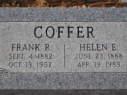
Frank R. Coffer
| Birth | : | 4 Sep 1882 |
| Death | : | 13 Oct 1957 San Francisco County, California, USA |
| Burial | : | Ebenezer Cemetery, Laflin, Bollinger County, USA |
| Coordinate | : | 37.3003006, -89.8899994 |
frequently asked questions (FAQ):
-
Where is Frank R. Coffer's memorial?
Frank R. Coffer's memorial is located at: Ebenezer Cemetery, Laflin, Bollinger County, USA.
-
When did Frank R. Coffer death?
Frank R. Coffer death on 13 Oct 1957 in San Francisco County, California, USA
-
Where are the coordinates of the Frank R. Coffer's memorial?
Latitude: 37.3003006
Longitude: -89.8899994
Family Members:
Parent
Spouse
Siblings

Children
Flowers:


Nearby Cemetories:
1. Ebenezer Cemetery
Laflin, Bollinger County, USA
Coordinate: 37.3003006, -89.8899994
2. Laflin Cemetery
Laflin, Bollinger County, USA
Coordinate: 37.2770157, -89.8894196
3. Formway Cemetery
Bollinger County, USA
Coordinate: 37.3166900, -89.9165400
4. Bailey Cemetery
Huskey, Bollinger County, USA
Coordinate: 37.3274994, -89.8957977
5. Crader Cemetery
Huskey, Bollinger County, USA
Coordinate: 37.3280983, -89.8711014
6. Stroder Cemetery
Cape Girardeau County, USA
Coordinate: 37.2860985, -89.8458023
7. Spivey Cemetery
Cape Girardeau County, USA
Coordinate: 37.2963982, -89.8386002
8. Perkins Cemetery
Bollinger County, USA
Coordinate: 37.2738991, -89.9313965
9. Barks Chapel Cemetery
Whitewater, Cape Girardeau County, USA
Coordinate: 37.2642212, -89.8592606
10. Hahn Chapel Cemetery
Marble Hill, Bollinger County, USA
Coordinate: 37.3061638, -89.9492645
11. Saint Johns Cemetery
Leopold, Bollinger County, USA
Coordinate: 37.2585983, -89.9282990
12. Proffer Cemetery
Crump, Cape Girardeau County, USA
Coordinate: 37.2807999, -89.8274994
13. Eaker Cemetery
Lutesville, Bollinger County, USA
Coordinate: 37.2778015, -89.9516983
14. Allen Cemetery
Burfordville, Cape Girardeau County, USA
Coordinate: 37.3424988, -89.8475037
15. Lessley Ridge Cemetery
Huskey, Bollinger County, USA
Coordinate: 37.3531075, -89.8720474
16. Crump Cemetery
Crump, Cape Girardeau County, USA
Coordinate: 37.2771988, -89.8174973
17. Marble Hill Cemetery
Marble Hill, Bollinger County, USA
Coordinate: 37.3032799, -89.9701309
18. Hood Cemetery
Leopold, Bollinger County, USA
Coordinate: 37.2355500, -89.8980100
19. Shell Cemetery
Lutesville, Bollinger County, USA
Coordinate: 37.2839012, -89.9693985
20. El Nathan Cemetery
Marble Hill, Bollinger County, USA
Coordinate: 37.3086710, -89.9757960
21. Barks Cemetery
Marble Hill, Bollinger County, USA
Coordinate: 37.3506012, -89.9494019
22. Hahn Cemetery
Lutesville, Bollinger County, USA
Coordinate: 37.2886009, -89.9772034
23. Gravel Hill Cemetery
Cape Girardeau, Cape Girardeau County, USA
Coordinate: 37.3689003, -89.8582993
24. Slaybaugh Cemetery
Lutesville, Bollinger County, USA
Coordinate: 37.2982150, -89.9851870