

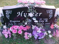
Gay Aileen Clark Hunter
| Birth | : | 15 Jun 1931 Andersonville, Franklin County, Indiana, USA |
| Death | : | 8 Jul 2002 Columbus, Bartholomew County, Indiana, USA |
| Burial | : | Spring Grove Cemetery, Cincinnati, Hamilton County, USA |
| Coordinate | : | 39.1647900, -84.5231500 |
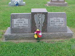
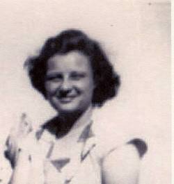
| Description | : | Gay A. Clark Hunter OBITUARY, Rushville [IN] Republican, Tuesday, July 9, 2002: Gay A. Hunter, 71, of Laurel, died Monday, July 8, 2002, at Columbus Regional Hospital in Columbus, Ind. Born June 15, 1931, in Andersonville, she was the daughter of Noland and Vina (Christian) Clark, both deceased. On March 6, 1948, she married Eugene Hunter; he preceded her in death on July 7, 1996. Mrs. Hunter lived in the Buena Vista area her... Read More |
frequently asked questions (FAQ):
-
Where is Gay Aileen Clark Hunter's memorial?
Gay Aileen Clark Hunter's memorial is located at: Spring Grove Cemetery, Cincinnati, Hamilton County, USA.
-
When did Gay Aileen Clark Hunter death?
Gay Aileen Clark Hunter death on 8 Jul 2002 in Columbus, Bartholomew County, Indiana, USA
-
Where are the coordinates of the Gay Aileen Clark Hunter's memorial?
Latitude: 39.1647900
Longitude: -84.5231500
Family Members:
Parent

Spouse
Siblings

Children

Flowers:


Nearby Cemetories:
1. Spring Grove Cemetery
Cincinnati, Hamilton County, USA
Coordinate: 39.1647900, -84.5231500
2. Saint John Cemetery
Saint Bernard, Hamilton County, USA
Coordinate: 39.1643982, -84.5053024
3. Vine Street Hill Cemetery
Cincinnati, Hamilton County, USA
Coordinate: 39.1516991, -84.5091019
4. Clifton United Jewish Cemetery
Cincinnati, Hamilton County, USA
Coordinate: 39.1470871, -84.5292816
5. Wesleyan Cemetery
Cincinnati, Hamilton County, USA
Coordinate: 39.1599998, -84.5468979
6. Third Quaker Cemetery (Defunct)
Cincinnati, Hamilton County, USA
Coordinate: 39.1542400, -84.5523720
7. Hillside Chapel Crematory and Columbarium
Cincinnati, Hamilton County, USA
Coordinate: 39.1393509, -84.5247192
8. Saint Mary Cemetery
Saint Bernard, Hamilton County, USA
Coordinate: 39.1664009, -84.4880981
9. Old Finneytown Cemetery
Finneytown, Hamilton County, USA
Coordinate: 39.1962220, -84.5206120
10. First German Protestant Cemetery
Avondale, Hamilton County, USA
Coordinate: 39.1492004, -84.4863968
11. Bishop Cemetery (Defunct)
College Hill, Hamilton County, USA
Coordinate: 39.1910210, -84.5489570
12. Methodist Protestant Cemetery (Defunct)
Cincinnati, Hamilton County, USA
Coordinate: 39.1324770, -84.4983160
13. Baltimore Pike Cemetery
Cincinnati, Hamilton County, USA
Coordinate: 39.1397018, -84.5681000
14. Convent of the Good Shepherd Cemetery (Defunct)
Carthage, Hamilton County, USA
Coordinate: 39.2055250, -84.5042780
15. Walnut Hills Cemetery
Cincinnati, Hamilton County, USA
Coordinate: 39.1355950, -84.4809040
16. Walnut Hills Jewish Cemetery
Evanston, Hamilton County, USA
Coordinate: 39.1403700, -84.4731300
17. Gard-Brown Cemetery
North Bend, Hamilton County, USA
Coordinate: 39.2035200, -84.5553300
18. Calvary Cemetery
Cincinnati, Hamilton County, USA
Coordinate: 39.1403008, -84.4697037
19. Longview Hospital Cemetery
Roselawn, Hamilton County, USA
Coordinate: 39.1887730, -84.4691660
20. Martini United Church of Christ Cemetery
Fairmount, Hamilton County, USA
Coordinate: 39.1296272, -84.5664902
21. Second Quaker Cemetery (Defunct)
Cincinnati, Hamilton County, USA
Coordinate: 39.1153090, -84.5305240
22. Christ Church Cemetery
Over-The-Rhine, Hamilton County, USA
Coordinate: 39.1126480, -84.5157623
23. Griffins Station Cemetery
Carthage, Hamilton County, USA
Coordinate: 39.2047000, -84.4770730
24. Jessup Cemetery
Mount Airy, Hamilton County, USA
Coordinate: 39.1970870, -84.5794270