
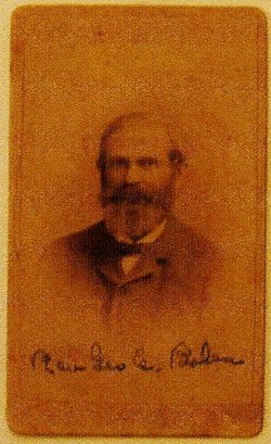

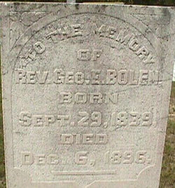
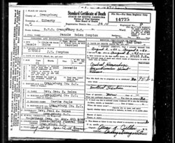
George Emanual Bolen
| Birth | : | 29 Sep 1839 Orangeburg County, South Carolina, USA |
| Death | : | 6 Dec 1896 |
| Burial | : | St. Mary's Churchyard, Marlingford, South Norfolk District, England |
| Coordinate | : | 52.6310660, 1.1416800 |
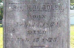
| Inscription | : | To the memory of Rev. George E. Bolen Oh husband dearest, father true How much we loved you never knew How pierced our hearts we cannot tell But Jesus doeth all things well. |
| Description | : | Son of Mary S. Bonnett Bolin Was a Baptist minister from whom the community of Bolin, or Bolin Town, in Orangeburg Co., SC, got its name. By trade he was a farmer and blacksmith. |
frequently asked questions (FAQ):
-
Where is George Emanual Bolen's memorial?
George Emanual Bolen's memorial is located at: St. Mary's Churchyard, Marlingford, South Norfolk District, England.
-
When did George Emanual Bolen death?
George Emanual Bolen death on 6 Dec 1896 in
-
Where are the coordinates of the George Emanual Bolen's memorial?
Latitude: 52.6310660
Longitude: 1.1416800
Family Members:
Parent

Spouse
Siblings
Children


Flowers:


Nearby Cemetories:
1. St. Mary's Churchyard
Marlingford, South Norfolk District, England
Coordinate: 52.6310660, 1.1416800
2. St Botolphs
Barford, South Norfolk District, England
Coordinate: 52.6287000, 1.1118000
3. St. Andrew's Churchyard
Colton, South Norfolk District, England
Coordinate: 52.6407700, 1.1089300
4. St. Mary and St. Walstan Churchyard
Bawburgh, South Norfolk District, England
Coordinate: 52.6327480, 1.1796530
5. All Saints & St Mary Churchyard
Great Melton, South Norfolk District, England
Coordinate: 52.6108700, 1.1602200
6. St. Peter's Churchyard
Easton, South Norfolk District, England
Coordinate: 52.6543660, 1.1478070
7. St Mary's and All Saints Churchyard
Little Melton, South Norfolk District, England
Coordinate: 52.6173083, 1.1798046
8. St Andrew's Churchyard
Honingham, Broadland District, England
Coordinate: 52.6573170, 1.1244600
9. Colney Woodland Burial Park
Colney, South Norfolk District, England
Coordinate: 52.6254580, 1.1991560
10. St Mary's Churchyard
Carleton Forehoe, South Norfolk District, England
Coordinate: 52.6100400, 1.0847490
11. St. Peter and St. Paul Churchyard
Barnham Broom, South Norfolk District, England
Coordinate: 52.6281830, 1.0749820
12. Costessey Parish Cemetery
Costessey, South Norfolk District, England
Coordinate: 52.6495927, 1.2040157
13. Saint Remigius Churchyard
Hethersett, South Norfolk District, England
Coordinate: 52.5992830, 1.1889340
14. St Michael's Church
Bowthorpe, City of Norwich, England
Coordinate: 52.6359300, 1.2163600
15. All Saints Churchyard
East Tuddenham, Breckland Borough, England
Coordinate: 52.6602410, 1.0813620
16. St. Andrew Churchyard
Colney, South Norfolk District, England
Coordinate: 52.6253800, 1.2206100
17. Our Lady & St. Walstan Churchyard
Costessey, South Norfolk District, England
Coordinate: 52.6583200, 1.2119300
18. Costessey Baptist Churchyard
Costessey, South Norfolk District, England
Coordinate: 52.6600122, 1.2116993
19. St. Peter's Churchyard
Ringland, Broadland District, England
Coordinate: 52.6822900, 1.1552400
20. All Saints Churchyard
Mattishall, Breckland Borough, England
Coordinate: 52.6498440, 1.0551390
21. All Saints, Welborne
South Norfolk District, England
Coordinate: 52.6496860, 1.0546670
22. St. Mary's Churchyard
Earlham, City of Norwich, England
Coordinate: 52.6280416, 1.2353034
23. St. Edmund's Churchyard
Taverham, Broadland District, England
Coordinate: 52.6789990, 1.1949460
24. St. Edmund's Churchyard
Costessey, South Norfolk District, England
Coordinate: 52.6660400, 1.2183410