
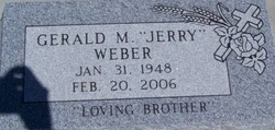
Gerald Michael “Jerry” Weber
| Birth | : | 31 Jan 1948 Hays, Ellis County, Kansas, USA |
| Death | : | 20 Feb 2006 Garnett, Anderson County, Kansas, USA |
| Burial | : | St John the Evangelist Churchyard, Hildenborough, Tonbridge and Malling Borough, England |
| Coordinate | : | 51.2174100, 0.2391660 |
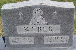
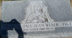
| Description | : | Gerald Michael "Jerry" Weber, 58, Salina, died Monday, Feb. 20, 2006. Mr. Weber was born Jan. 31, 1948, in Ellis, the son of the late Joseph Ignatius and Evelyn (Whitman) Weber. He was a retired warehouse worker at a sporting goods store. He was preceded in death by his wife, Mary E.; and a sister, Norma Jean Weber. Survivors include two brothers, Robert L. and wife Shirley of Colby and Harold and wife Rita of Salina; a sister, Janet Ziegler and husband Ron of WaKeeney; and many nieces and nephews. A graveside service will be at 10 a.m. Thursday in... Read More |
frequently asked questions (FAQ):
-
Where is Gerald Michael “Jerry” Weber's memorial?
Gerald Michael “Jerry” Weber's memorial is located at: St John the Evangelist Churchyard, Hildenborough, Tonbridge and Malling Borough, England.
-
When did Gerald Michael “Jerry” Weber death?
Gerald Michael “Jerry” Weber death on 20 Feb 2006 in Garnett, Anderson County, Kansas, USA
-
Where are the coordinates of the Gerald Michael “Jerry” Weber's memorial?
Latitude: 51.2174100
Longitude: 0.2391660
Family Members:
Parent

Siblings
Flowers:


Nearby Cemetories:
1. St John the Evangelist Churchyard
Hildenborough, Tonbridge and Malling Borough, England
Coordinate: 51.2174100, 0.2391660
2. Hildenborough War Memorial
Hildenborough, Tonbridge and Malling Borough, England
Coordinate: 51.2175827, 0.2372410
3. St. Mary's Churchyard
Leigh, Sevenoaks District, England
Coordinate: 51.1977660, 0.2151510
4. Tonbridge Cemetery
Tonbridge, Tonbridge and Malling Borough, England
Coordinate: 51.2057762, 0.2772440
5. St. Margaret's Churchyard
Underriver, Sevenoaks District, England
Coordinate: 51.2458191, 0.2291520
6. Tonbridge Castle
Tonbridge, Tonbridge and Malling Borough, England
Coordinate: 51.1987000, 0.2764000
7. St Peter and St Paul Church
Tonbridge, Tonbridge and Malling Borough, England
Coordinate: 51.1977660, 0.2764630
8. St Stephens
Tonbridge, Tonbridge and Malling Borough, England
Coordinate: 51.1893961, 0.2687135
9. St Giles Churchyard
Shipbourne, Tonbridge and Malling Borough, England
Coordinate: 51.2471700, 0.2786090
10. St Luke Churchyard
Chiddingstone Causeway, Sevenoaks District, England
Coordinate: 51.1974910, 0.1758540
11. Ightham Mote
Ightham, Tonbridge and Malling Borough, England
Coordinate: 51.2584610, 0.2695830
12. St. Lawrence Churchyard
Bidborough, Tunbridge Wells Borough, England
Coordinate: 51.1666950, 0.2371870
13. Southborough War Memorial
Southborough, Tunbridge Wells Borough, England
Coordinate: 51.1639214, 0.2528920
14. Plaxtol Parish Churchyard
Plaxtol, Tonbridge and Malling Borough, England
Coordinate: 51.2593498, 0.2945710
15. Plaxtol War Memorial
Plaxtol, Tonbridge and Malling Borough, England
Coordinate: 51.2592888, 0.2948450
16. St. Peter's Churchyard
Southborough, Tunbridge Wells Borough, England
Coordinate: 51.1626549, 0.2520690
17. St. John the Baptist Churchyard
Penshurst, Sevenoaks District, England
Coordinate: 51.1735240, 0.1834540
18. Holy Trinity Churchyard
Crockham Hill, Sevenoaks District, England
Coordinate: 51.1982790, 0.1538090
19. St Nicholas Churchyard
Sevenoaks, Sevenoaks District, England
Coordinate: 51.2673310, 0.1933100
20. St. Lawrence Churchyard
Seal Chart, Sevenoaks District, England
Coordinate: 51.2742910, 0.2537250
21. Southborough Cemetery
Southborough, Tunbridge Wells Borough, England
Coordinate: 51.1592860, 0.2420140
22. All Saints Churchyard
Tudeley, Tunbridge Wells Borough, England
Coordinate: 51.1848510, 0.3186970
23. Chiddingstone Churchyard Extension
Chiddingstone, Sevenoaks District, England
Coordinate: 51.1861590, 0.1488930
24. Sevenoaks War Memorial
Sevenoaks, Sevenoaks District, England
Coordinate: 51.2761078, 0.1927860