
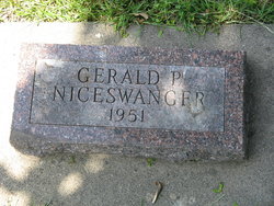
Gerald Paul Niceswanger
| Birth | : | 27 Jan 1951 Carroll, Carroll County, Iowa, USA |
| Death | : | 27 Jan 1951 Carroll, Carroll County, Iowa, USA |
| Burial | : | St John the Baptist Churchyard, Cold Overton, Melton Borough, England |
| Coordinate | : | 52.6829560, -0.8027660 |
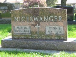
| Description | : | He was the son of Dennis and Marian Niceswanger. He lived only about three hours. |
frequently asked questions (FAQ):
-
Where is Gerald Paul Niceswanger's memorial?
Gerald Paul Niceswanger's memorial is located at: St John the Baptist Churchyard, Cold Overton, Melton Borough, England.
-
When did Gerald Paul Niceswanger death?
Gerald Paul Niceswanger death on 27 Jan 1951 in Carroll, Carroll County, Iowa, USA
-
Where are the coordinates of the Gerald Paul Niceswanger's memorial?
Latitude: 52.6829560
Longitude: -0.8027660
Family Members:
Parent
Flowers:


Nearby Cemetories:
1. St John the Baptist Churchyard
Cold Overton, Melton Borough, England
Coordinate: 52.6829560, -0.8027660
2. St Peter Churchyard
Knossington, Melton Borough, England
Coordinate: 52.6699000, -0.8168600
3. All Saints Churchyard, Pickwell
Melton Mowbray, Melton Borough, England
Coordinate: 52.6943280, -0.8388740
4. Pickwell Road Cemetery
Somerby, Melton Borough, England
Coordinate: 52.6865550, -0.8444540
5. All Saints Churchyard
Somerby, Melton Borough, England
Coordinate: 52.6864700, -0.8482390
6. SS Peter and Paul Church
Langham, Rutland Unitary Authority, England
Coordinate: 52.6918700, -0.7529300
7. Saint Andrew's Churchyard
Owston, Harborough District, England
Coordinate: 52.6642540, -0.8561200
8. Withcote Chapel
Harborough District, England
Coordinate: 52.6440500, -0.8253346
9. St Andrew Churchyard
Whissendine, Rutland Unitary Authority, England
Coordinate: 52.7200520, -0.7682370
10. Oakham Cemetery
Oakham, Rutland Unitary Authority, England
Coordinate: 52.6768700, -0.7297400
11. St James the Greater Churchyard
Little Dalby, Melton Borough, England
Coordinate: 52.7149700, -0.8543800
12. St Mary the Virgin Churchyard
Somerby, Melton Borough, England
Coordinate: 52.6894150, -0.8806740
13. Launde Abbey
Launde, Harborough District, England
Coordinate: 52.6313950, -0.8233060
14. St Mary the Virgin Churchyard
Ashwell, Rutland Unitary Authority, England
Coordinate: 52.7144490, -0.7200580
15. Holy Trinity Churchyard
Teigh, Rutland Unitary Authority, England
Coordinate: 52.7348560, -0.7207040
16. St James Churchyard
Burton Lazars, Melton Borough, England
Coordinate: 52.7446910, -0.8643730
17. St Andrew Churchyard
Twyford, Melton Borough, England
Coordinate: 52.6835600, -0.9217660
18. St Peter Churchyard
Tilton-on-the-Hill, Harborough District, England
Coordinate: 52.6435650, -0.9026860
19. St Swithun Churchyard
Great Dalby, Melton Borough, England
Coordinate: 52.7224510, -0.9027190
20. St. Mary Magdalen Churchyard
Stapleford, Melton Borough, England
Coordinate: 52.7553000, -0.7987000
21. Saint Michael and All Angels Churchyard
Edmondthorpe, Melton Borough, England
Coordinate: 52.7488800, -0.7301600
22. St Peter Churchyard
Belton, Rutland Unitary Authority, England
Coordinate: 52.6038200, -0.7957000
23. Edmondthorpe Main Street Cemetery
Edmondthorpe, Melton Borough, England
Coordinate: 52.7491560, -0.7300030
24. St. Mary Churchyard
Wyfordby, Melton Borough, England
Coordinate: 52.7621940, -0.8257020