
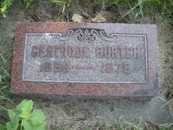
Gertrude Winifred Schultz Burtch
| Birth | : | 6 Jul 1896 Davis, Turner County, South Dakota, USA |
| Death | : | Jun 1973 Bartlesville, Washington County, Oklahoma, USA |
| Burial | : | Spring Run Cemetery, Spring Run, Franklin County, USA |
| Coordinate | : | 40.1436110, -77.7722220 |
| Plot | : | Bethel Reformed |
frequently asked questions (FAQ):
-
Where is Gertrude Winifred Schultz Burtch's memorial?
Gertrude Winifred Schultz Burtch's memorial is located at: Spring Run Cemetery, Spring Run, Franklin County, USA.
-
When did Gertrude Winifred Schultz Burtch death?
Gertrude Winifred Schultz Burtch death on Jun 1973 in Bartlesville, Washington County, Oklahoma, USA
-
Where are the coordinates of the Gertrude Winifred Schultz Burtch's memorial?
Latitude: 40.1436110
Longitude: -77.7722220
Family Members:
Spouse

Children
Flowers:


Nearby Cemetories:
1. Wiggins Cemetery
Tell Township, Huntingdon County, USA
Coordinate: 40.1346600, -77.7748563
2. Path Valley Cemetery
Spring Run, Franklin County, USA
Coordinate: 40.1547012, -77.7658005
3. Parker Cemetery
Metal Township, Franklin County, USA
Coordinate: 40.1271763, -77.8050054
4. Shetler Family Cemetery
Franklin County, USA
Coordinate: 40.1100000, -77.7833000
5. Pine Grove Presbyterian Church Cemetery
Neelyton, Huntingdon County, USA
Coordinate: 40.1605400, -77.8170200
6. Fleming Cemetery
Neelyton, Huntingdon County, USA
Coordinate: 40.1333330, -77.8375000
7. Flickinger Farm Family Cemetery
Franklin County, USA
Coordinate: 40.0927480, -77.8015170
8. Evert Farm Family Cemetery
Metal, Franklin County, USA
Coordinate: 40.0794670, -77.7987490
9. Salem Cemetery
Tell Township, Huntingdon County, USA
Coordinate: 40.2069400, -77.8099800
10. Stake Cemetery
Amberson, Franklin County, USA
Coordinate: 40.1610170, -77.6820090
11. Pleasant Hill Cemetery
Shade Gap, Huntingdon County, USA
Coordinate: 40.1425844, -77.8661077
12. Possumtown Cemetery
Shade Gap, Huntingdon County, USA
Coordinate: 40.1857900, -77.8498900
13. Blair Cemetery
Shade Gap, Huntingdon County, USA
Coordinate: 40.1698800, -77.8655300
14. Amberson Union Cemetery
Amberson, Franklin County, USA
Coordinate: 40.1709200, -77.6767700
15. Shade Gap Presbyterian Church Cemetery
Shade Gap, Huntingdon County, USA
Coordinate: 40.1826400, -77.8624700
16. McMullen Cemetery
Tell Township, Huntingdon County, USA
Coordinate: 40.2108189, -77.8301899
17. Fannettsburg Reformed Church Cemetery
Fannettsburg, Franklin County, USA
Coordinate: 40.0735000, -77.8277000
18. Cree Cemetery
Dublin Township, Huntingdon County, USA
Coordinate: 40.0982014, -77.8660481
19. Our Lady Of Refuge Cemetery
Doylesburg, Franklin County, USA
Coordinate: 40.2140530, -77.7060900
20. Fair Ridge Cemetery
Shade Gap, Huntingdon County, USA
Coordinate: 40.1356300, -77.8858200
21. Doylesburg United Methodist Cemetery
Doylesburg, Franklin County, USA
Coordinate: 40.2139910, -77.7009990
22. Nossville Cemetery
Nossville, Huntingdon County, USA
Coordinate: 40.2342400, -77.7649000
23. Crow Cemetery
Tell Township, Huntingdon County, USA
Coordinate: 40.2296329, -77.8156254
24. Roxbury Union Cemetery
Roxbury, Franklin County, USA
Coordinate: 40.1099200, -77.6593900