
| Memorials | : | 0 |
| Location | : | Franklin County, USA |
| Coordinate | : | 40.0927480, -77.8015170 |
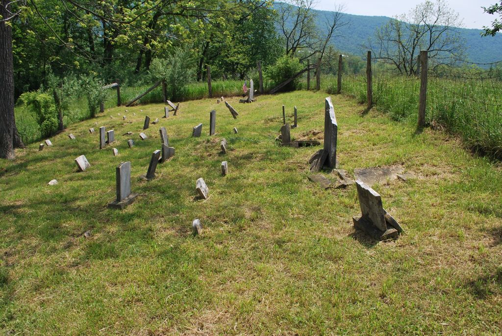
| Description | : | This cemetery is located on the east side of Pennsylvania Route 75 (Path Valley Road) approx. one-fourth mile north of Exit 14 of U.S. 76 (Pennsylvania Turnpike), in Metal Twp, Franklin County, Pennsylvania. The cemetery is no longer in use and was mowed when visited in May 2013. In the past cattle were allowed to graze in the plot and many of the stones were broken and left very difficult to read. The cemetery is now enclosed by a fence which has been erected around the cemetery plot. Access to the cemetery is through the cattle pasture and... Read More |
frequently asked questions (FAQ):
-
Where is Flickinger Farm Family Cemetery?
Flickinger Farm Family Cemetery is located at Metal Township Franklin County ,Pennsylvania ,USA.
-
Flickinger Farm Family Cemetery cemetery's updated grave count on graveviews.com?
0 memorials
-
Where are the coordinates of the Flickinger Farm Family Cemetery?
Latitude: 40.0927480
Longitude: -77.8015170
Nearby Cemetories:
1. Evert Farm Family Cemetery
Metal, Franklin County, USA
Coordinate: 40.0794670, -77.7987490
2. Shetler Family Cemetery
Franklin County, USA
Coordinate: 40.1100000, -77.7833000
3. Fannettsburg Reformed Church Cemetery
Fannettsburg, Franklin County, USA
Coordinate: 40.0735000, -77.8277000
4. Parker Cemetery
Metal Township, Franklin County, USA
Coordinate: 40.1271763, -77.8050054
5. Wiggins Cemetery
Tell Township, Huntingdon County, USA
Coordinate: 40.1346600, -77.7748563
6. Fleming Cemetery
Neelyton, Huntingdon County, USA
Coordinate: 40.1333330, -77.8375000
7. Cree Cemetery
Dublin Township, Huntingdon County, USA
Coordinate: 40.0982014, -77.8660481
8. Lower Path Valley Cemetery
Fannettsburg, Franklin County, USA
Coordinate: 40.0531006, -77.8450012
9. Keefers Cemetery
Upper Strasburg, Franklin County, USA
Coordinate: 40.0406550, -77.8079090
10. Horse Valley Cemetery
Franklin County, USA
Coordinate: 40.0386009, -77.8058014
11. Spring Run Cemetery
Spring Run, Franklin County, USA
Coordinate: 40.1436110, -77.7722220
12. Path Valley Cemetery
Spring Run, Franklin County, USA
Coordinate: 40.1547012, -77.7658005
13. Pine Grove Presbyterian Church Cemetery
Neelyton, Huntingdon County, USA
Coordinate: 40.1605400, -77.8170200
14. Pleasant Hill Cemetery
Shade Gap, Huntingdon County, USA
Coordinate: 40.1425844, -77.8661077
15. Burnt Cabins Cemetery
Burnt Cabins, Fulton County, USA
Coordinate: 40.0754000, -77.8963000
16. New Hope Mennonite Cemetery
Upper Strasburg, Franklin County, USA
Coordinate: 40.0628950, -77.7099840
17. Upper Strasburg Methodist Church Cemetery
Upper Strasburg, Franklin County, USA
Coordinate: 40.0596000, -77.7105000
18. Fair Ridge Cemetery
Shade Gap, Huntingdon County, USA
Coordinate: 40.1356300, -77.8858200
19. Forrester Family Cemetery
Freestone, Franklin County, USA
Coordinate: 40.0172290, -77.8317830
20. Emanuel Lutheran Church Cemetery
Upper Strasburg, Franklin County, USA
Coordinate: 40.0587000, -77.7049000
21. Metal Methodist Cemetery
Metal, Franklin County, USA
Coordinate: 40.0240000, -77.8725000
22. Blair Cemetery
Shade Gap, Huntingdon County, USA
Coordinate: 40.1698800, -77.8655300
23. Wright Farm Family Cemetery
Metal, Franklin County, USA
Coordinate: 40.0213364, -77.8832249
24. Carrick United Methodist Church Cemetery
Metal, Franklin County, USA
Coordinate: 40.0151850, -77.8783810