

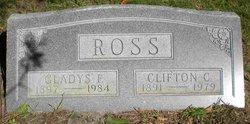
Gladys Fern Posegate Ross
| Birth | : | 30 Jun 1897 Kelley, Story County, Iowa, USA |
| Death | : | 1984 |
| Burial | : | St. Editha Churchyard, Tamworth, Tamworth Borough, England |
| Coordinate | : | 52.6344040, -1.6946000 |
frequently asked questions (FAQ):
-
Where is Gladys Fern Posegate Ross's memorial?
Gladys Fern Posegate Ross's memorial is located at: St. Editha Churchyard, Tamworth, Tamworth Borough, England.
-
When did Gladys Fern Posegate Ross death?
Gladys Fern Posegate Ross death on 1984 in
-
Where are the coordinates of the Gladys Fern Posegate Ross's memorial?
Latitude: 52.6344040
Longitude: -1.6946000
Family Members:
Parent
Spouse
Siblings

Flowers:


Nearby Cemetories:
1. St. Editha Churchyard
Tamworth, Tamworth Borough, England
Coordinate: 52.6344040, -1.6946000
2. Glascote Cemetery
Glascote, Tamworth Borough, England
Coordinate: 52.6290130, -1.6774860
3. Wigginton Road Cemetery
Tamworth, Tamworth Borough, England
Coordinate: 52.6479590, -1.6928170
4. St. Paul's Churchyard
Fazeley, Lichfield District, England
Coordinate: 52.6128860, -1.7002090
5. Amington Cemetery
Amington, Tamworth Borough, England
Coordinate: 52.6356092, -1.6552355
6. Hopwas Cemetery
Tamworth, Tamworth Borough, England
Coordinate: 52.6417200, -1.7362600
7. Wilnecote New Cemetery
Wilnecote, Tamworth Borough, England
Coordinate: 52.6119140, -1.6716640
8. Wilencote Old Cemetery
Wilnecote, Tamworth Borough, England
Coordinate: 52.6099808, -1.6676261
9. St Chad's
Tamworth Borough, England
Coordinate: 52.6433000, -1.7418000
10. St Leonard Churchyard
Wigginton and Hopwas, Lichfield District, England
Coordinate: 52.6704490, -1.6927530
11. St Peter Churchyard
Drayton Bassett, Lichfield District, England
Coordinate: 52.5993180, -1.7165990
12. Chapel of All Saints, Statfold
Thorpe Constantine, Lichfield District, England
Coordinate: 52.6611100, -1.6510330
13. St. Matthew's Churchyard
Shuttington, North Warwickshire Borough, England
Coordinate: 52.6440000, -1.6244720
14. St Bartholomew Churchyard
Hints, Lichfield District, England
Coordinate: 52.6237460, -1.7683840
15. Polesworth Abbey Churchyard
Polesworth, North Warwickshire Borough, England
Coordinate: 52.6193460, -1.6115790
16. All Saints Churchyard
Seckington, North Warwickshire Borough, England
Coordinate: 52.6638760, -1.6167310
17. St. Giles' Churchyard
Whittington, Lichfield District, England
Coordinate: 52.6723850, -1.7677160
18. St John the Baptist Churchyard
Middleton, North Warwickshire Borough, England
Coordinate: 52.5826140, -1.7406020
19. St Mary the Virgin New Churchyard
Weeford, Lichfield District, England
Coordinate: 52.6330806, -1.7923083
20. St. Mary the Virgin Churchyard
Weeford, Lichfield District, England
Coordinate: 52.6322300, -1.7923200
21. St Leonard's Churchyard
Dordon, North Warwickshire Borough, England
Coordinate: 52.6004250, -1.6132720
22. St Peter's Churchyard
Elford, Lichfield District, England
Coordinate: 52.6928330, -1.7274120
23. St. Matthew's churchyard
Harlaston, Lichfield District, England
Coordinate: 52.6957682, -1.6832017
24. St Michael & St James Catholic Churchyard
Haunton, Lichfield District, England
Coordinate: 52.6946050, -1.6514690