
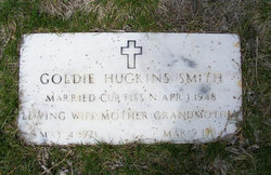
Goldie Geraldine Huckins Smith
| Birth | : | 4 May 1921 |
| Death | : | 9 Mar 1994 |
| Burial | : | All Saints Churchyard, Newborough, East Staffordshire Borough, England |
| Coordinate | : | 52.8259013, -1.8003185 |
frequently asked questions (FAQ):
-
Where is Goldie Geraldine Huckins Smith's memorial?
Goldie Geraldine Huckins Smith's memorial is located at: All Saints Churchyard, Newborough, East Staffordshire Borough, England.
-
When did Goldie Geraldine Huckins Smith death?
Goldie Geraldine Huckins Smith death on 9 Mar 1994 in
-
Where are the coordinates of the Goldie Geraldine Huckins Smith's memorial?
Latitude: 52.8259013
Longitude: -1.8003185
Family Members:
Parent

Spouse
Siblings

Flowers:


Nearby Cemetories:
1. All Saints Churchyard
Newborough, East Staffordshire Borough, England
Coordinate: 52.8259013, -1.8003185
2. Newchurch, Christchurch-in-Needwood
Hoar Cross, East Staffordshire Borough, England
Coordinate: 52.8083859, -1.7811304
3. The Holy Angels Churchyard
Hoar Cross, East Staffordshire Borough, England
Coordinate: 52.8047974, -1.8161691
4. St Werburgh's Church
Hanbury, East Staffordshire Borough, England
Coordinate: 52.8485000, -1.7478000
5. Catholic Church of Saint Francis of Sales
Yoxall, East Staffordshire Borough, England
Coordinate: 52.7844140, -1.7909000
6. All Saints Churchyard
Rangemore, East Staffordshire Borough, England
Coordinate: 52.8040800, -1.7337000
7. RAF Fauld
Hanbury, East Staffordshire Borough, England
Coordinate: 52.8474200, -1.7303500
8. St Peter's Churchyard
Marchington, East Staffordshire Borough, England
Coordinate: 52.8738278, -1.7967917
9. St. Nicholas Churchyard
Abbots Bromley, East Staffordshire Borough, England
Coordinate: 52.8184560, -1.8837460
10. Holy Trinity Churchyard
Anslow, East Staffordshire Borough, England
Coordinate: 52.8216926, -1.7079807
11. St. Peter's Churchyard
Yoxall, East Staffordshire Borough, England
Coordinate: 52.7687960, -1.7915250
12. St. Michael & All Angels Churchyard
Hamstall Ridware, Lichfield District, England
Coordinate: 52.7716100, -1.8447300
13. All Saints Churchyard
Sudbury, Derbyshire Dales District, England
Coordinate: 52.8867660, -1.7667510
14. St. Mary's Churchyard, Dunstall
Tatenhill, East Staffordshire Borough, England
Coordinate: 52.7809957, -1.7236464
15. St. Paul's Churchyard Extension
Scropton, South Derbyshire District, England
Coordinate: 52.8687230, -1.7133750
16. St. Michael and All Angels Churchyard
Tatenhill, East Staffordshire Borough, England
Coordinate: 52.7958170, -1.6968150
17. Priory Church of St. Mary the Virgin
Tutbury, East Staffordshire Borough, England
Coordinate: 52.8590900, -1.6877900
18. St. John the Baptist Churchyard
Kingstone, East Staffordshire Borough, England
Coordinate: 52.8630944, -1.9115108
19. St. James' Churchyard
Barton-under-Needwood, East Staffordshire Borough, England
Coordinate: 52.7641321, -1.7228176
20. St. Cuthbert's Churchyard
Doveridge, Derbyshire Dales District, England
Coordinate: 52.9042368, -1.8317361
21. Saint Mary the Virgin Churchyard
Uttoxeter, East Staffordshire Borough, England
Coordinate: 52.8987700, -1.8624100
22. Rolleston Cemetery
Rolleston-on-Dove, East Staffordshire Borough, England
Coordinate: 52.8483757, -1.6643849
23. Dove Evangelical Free Church, Somersal Herbert
Doveridge, Derbyshire Dales District, England
Coordinate: 52.9109200, -1.7905560
24. Saint Saviour's Cemetery
Burton upon Trent, East Staffordshire Borough, England
Coordinate: 52.7892907, -1.6668628