
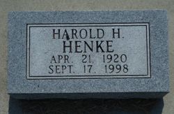
Harold Henry Henke
| Birth | : | 21 Apr 1920 Greeley County, Nebraska, USA |
| Death | : | 17 Sep 1998 Omaha, Douglas County, Nebraska, USA |
| Burial | : | St. James the Great Churchyard, Colwall, Herefordshire Unitary Authority, England |
| Coordinate | : | 52.0785300, -2.3821400 |
| Description | : | Son of Frank Sr. & Lora (Moeller) Henke. |
frequently asked questions (FAQ):
-
Where is Harold Henry Henke's memorial?
Harold Henry Henke's memorial is located at: St. James the Great Churchyard, Colwall, Herefordshire Unitary Authority, England.
-
When did Harold Henry Henke death?
Harold Henry Henke death on 17 Sep 1998 in Omaha, Douglas County, Nebraska, USA
-
Where are the coordinates of the Harold Henry Henke's memorial?
Latitude: 52.0785300
Longitude: -2.3821400
Family Members:
Parent
Siblings

Flowers:


Nearby Cemetories:
1. St. James the Great Churchyard
Colwall, Herefordshire Unitary Authority, England
Coordinate: 52.0785300, -2.3821400
2. All Saints Churchyard
Coddington, Herefordshire Unitary Authority, England
Coordinate: 52.0820020, -2.4123970
3. St Peter's Churchyard
Malvern Wells, Malvern Hills District, England
Coordinate: 52.0783528, -2.3322165
4. St. Wulstan Roman Catholic Churchyard
Little Malvern, Malvern Hills District, England
Coordinate: 52.0666050, -2.3356450
5. Malvern Wells Cemetery
Malvern Wells, Malvern Hills District, England
Coordinate: 52.0779911, -2.3286663
6. Little Malvern Priory
Little Malvern, Malvern Hills District, England
Coordinate: 52.0612500, -2.3365800
7. St. James's Churchyard
West Malvern, Malvern Hills District, England
Coordinate: 52.1127220, -2.3469830
8. Holy Trinity Churchyard
Bosbury, Herefordshire Unitary Authority, England
Coordinate: 52.0885430, -2.4459180
9. St. James' the Great Churchyard
Cradley, Herefordshire Unitary Authority, England
Coordinate: 52.1218440, -2.3870920
10. Cradley Chapel
Cradley, Herefordshire Unitary Authority, England
Coordinate: 52.1215478, -2.4001078
11. St. John the Baptist
Eastnor, Herefordshire Unitary Authority, England
Coordinate: 52.0330980, -2.3932590
12. Great Malvern Priory Churchyard
Great Malvern, Malvern Hills District, England
Coordinate: 52.1106750, -2.3284660
13. St. Michael and All Angels Churchyard
Ledbury, Herefordshire Unitary Authority, England
Coordinate: 52.0369300, -2.4199360
14. St James Churchyard
Great Malvern, Malvern Hills District, England
Coordinate: 52.1197650, -2.3316900
15. Welland Cemetery
Welland, Malvern Hills District, England
Coordinate: 52.0591625, -2.3021845
16. St. Peter's Churchyard
Malvern Link, Malvern Hills District, England
Coordinate: 52.1259530, -2.3380280
17. Great Malvern Cemetery
Great Malvern, Malvern Hills District, England
Coordinate: 52.1133010, -2.3135120
18. St. James Churchyard
Welland, Malvern Hills District, England
Coordinate: 52.0577700, -2.2974900
19. All Saints Churchyard
Hollybush, Malvern Hills District, England
Coordinate: 52.0282510, -2.3384140
20. Ledbury Cemetery
Ledbury, Herefordshire Unitary Authority, England
Coordinate: 52.0308400, -2.4331830
21. St. Gabriel's Churchyard
Hanley Swan, Malvern Hills District, England
Coordinate: 52.0829420, -2.2784110
22. St. Matthias Churchyard
Malvern Link, Malvern Hills District, England
Coordinate: 52.1290490, -2.3178900
23. Our Lady & St Alphonsus Catholic Churchyard
Hanley Swan, Malvern Hills District, England
Coordinate: 52.0907960, -2.2753160
24. St. Gregory Churchyard
Castlemorton, Malvern Hills District, England
Coordinate: 52.0332900, -2.3003800