
| Memorials | : | 0 |
| Location | : | Malvern Link, Malvern Hills District, England |
| Coordinate | : | 52.1290490, -2.3178900 |
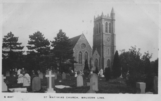
| Description | : | St Matthias was built between 1844 and 1846 and consecrated 13th January 1846 by the Bishop of Worcester, with the land surrounding it consecrated as a burial ground. |
frequently asked questions (FAQ):
-
Where is St. Matthias Churchyard?
St. Matthias Churchyard is located at Malvern Link, Malvern Hills District ,Worcestershire ,England.
-
St. Matthias Churchyard cemetery's updated grave count on graveviews.com?
0 memorials
-
Where are the coordinates of the St. Matthias Churchyard?
Latitude: 52.1290490
Longitude: -2.3178900
Nearby Cemetories:
1. Convent of the Holy Name, Chapel and Cloister
Malvern Link, Malvern Hills District, England
Coordinate: 52.1304500, -2.3068900
2. St James Churchyard
Great Malvern, Malvern Hills District, England
Coordinate: 52.1197650, -2.3316900
3. St. Peter's Churchyard
Malvern Link, Malvern Hills District, England
Coordinate: 52.1259530, -2.3380280
4. Newland Cemetery
Newland, Malvern Hills District, England
Coordinate: 52.1342764, -2.2988052
5. Great Malvern Cemetery
Great Malvern, Malvern Hills District, England
Coordinate: 52.1133010, -2.3135120
6. Great Malvern Priory Churchyard
Great Malvern, Malvern Hills District, England
Coordinate: 52.1106750, -2.3284660
7. St Mary the Virgin Churchyard
Madresfield, Malvern Hills District, England
Coordinate: 52.1252800, -2.2864800
8. St. James's Churchyard
West Malvern, Malvern Hills District, England
Coordinate: 52.1127220, -2.3469830
9. St. John the Baptist Churchyard
Bransford, Malvern Hills District, England
Coordinate: 52.1616486, -2.2981676
10. St. Mary's Churchyard
Guarlford, Malvern Hills District, England
Coordinate: 52.1061887, -2.2738220
11. Worcester County Pauper and Lunatic Asylum Cemetery
Powick, Malvern Hills District, England
Coordinate: 52.1530276, -2.2599550
12. St. James' the Great Churchyard
Cradley, Herefordshire Unitary Authority, England
Coordinate: 52.1218440, -2.3870920
13. Our Lady & St Alphonsus Catholic Churchyard
Hanley Swan, Malvern Hills District, England
Coordinate: 52.0907960, -2.2753160
14. Stanbrook Abbey
Callow End, Malvern Hills District, England
Coordinate: 52.1389670, -2.2398380
15. St. Eadburga Churchyard
Leigh, Malvern Hills District, England
Coordinate: 52.1789500, -2.3169500
16. Cradley Chapel
Cradley, Herefordshire Unitary Authority, England
Coordinate: 52.1215478, -2.4001078
17. St Peter's Churchyard
Malvern Wells, Malvern Hills District, England
Coordinate: 52.0783528, -2.3322165
18. Malvern Wells Cemetery
Malvern Wells, Malvern Hills District, England
Coordinate: 52.0779911, -2.3286663
19. St. Gabriel's Churchyard
Hanley Swan, Malvern Hills District, England
Coordinate: 52.0829420, -2.2784110
20. St Mary Magdalene Churchyard
Alfrick, Malvern Hills District, England
Coordinate: 52.1744230, -2.3693070
21. St Peter's Church Burial Ground
Powick, Malvern Hills District, England
Coordinate: 52.1613890, -2.2432490
22. St. Mary the Virgin Churchyard
Kempsey, Malvern Hills District, England
Coordinate: 52.1396580, -2.2231290
23. St Leonard Churchyard
Cotheridge, Malvern Hills District, England
Coordinate: 52.1903100, -2.3139500
24. St. Wulstan Roman Catholic Churchyard
Little Malvern, Malvern Hills District, England
Coordinate: 52.0666050, -2.3356450