| Birth | : | 25 Mar 1928 Aurelia, Cherokee County, Iowa, USA |
| Death | : | 28 Feb 2006 Cherokee, Cherokee County, Iowa, USA |
| Burial | : | St. Denis Churchyard, Silk Willoughby, North Kesteven District, England |
| Coordinate | : | 52.9738460, -0.4268830 |
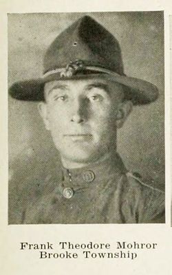
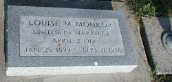
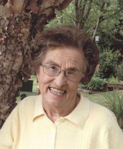
| Description | : | Harriet L. (Mohror) Zarr, 77, died Tuesday, February 28, 2006, at the Cherokee Regional Medical Center in Cherokee, Iowa. Harriet Louise Mohror was born on March 25, 1928, the daughter of Frank and Louise (Luetkeman) Mohror at Aurelia. Burial was in the Afton Township Cemetery, rural Cherokee. Funeral services for Harriet L. (Mohror) Zarr, of Aurelia, Iowa, were 10:30 A.M. Friday, March 3, 2006, at the First United Methodist Church in Aurelia with Pastor Harold Werley officiating. She attended Brooke School and graduated from the Peterson High School in 1946. In September of... Read More |
frequently asked questions (FAQ):
-
Where is Harriet Louise Mohror Zarr's memorial?
Harriet Louise Mohror Zarr's memorial is located at: St. Denis Churchyard, Silk Willoughby, North Kesteven District, England.
-
When did Harriet Louise Mohror Zarr death?
Harriet Louise Mohror Zarr death on 28 Feb 2006 in Cherokee, Cherokee County, Iowa, USA
-
Where are the coordinates of the Harriet Louise Mohror Zarr's memorial?
Latitude: 52.9738460
Longitude: -0.4268830
Family Members:
Parent
Spouse
Siblings
Flowers:
Nearby Cemetories:
1. St. Denis Churchyard
Silk Willoughby, North Kesteven District, England
Coordinate: 52.9738460, -0.4268830
2. St Denys Churchyard
Silk Willoughby, North Kesteven District, England
Coordinate: 52.9736976, -0.4263297
3. St Botolph Churchyard
Quarrington, North Kesteven District, England
Coordinate: 52.9872010, -0.4312350
4. Rauceby Hospital Cemetery
Quarrington, North Kesteven District, England
Coordinate: 52.9807077, -0.4549731
5. St Denys Churchyard
Sleaford, North Kesteven District, England
Coordinate: 52.9996510, -0.4088960
6. Sleaford Cemetery
Sleaford, North Kesteven District, England
Coordinate: 53.0027590, -0.4056790
7. St Thomas Churchyard
Aunsby, North Kesteven District, England
Coordinate: 52.9367820, -0.4470450
8. St. Andrew's Churchyard
Scredington, North Kesteven District, England
Coordinate: 52.9498300, -0.3701700
9. St Peter's Churchyard
North Rauceby, North Kesteven District, England
Coordinate: 53.0056400, -0.4796500
10. St Peter & St Paul Churchyard
Osbournby, North Kesteven District, England
Coordinate: 52.9298800, -0.4105100
11. St. Mary's Churchyard
Wilsford, North Kesteven District, England
Coordinate: 52.9751600, -0.5023700
12. St. Denys Churchyard
Kirkby la Thorpe, North Kesteven District, England
Coordinate: 53.0008270, -0.3636800
13. St. Lucia Churchyard
Dembleby, North Kesteven District, England
Coordinate: 52.9268000, -0.4512300
14. St Andrew Churchyard
Leasingham, North Kesteven District, England
Coordinate: 53.0239040, -0.4262600
15. St Andrew Churchyard
Kelby, North Kesteven District, England
Coordinate: 52.9608000, -0.5074000
16. St. Andrew's Churchyard
South Kesteven District, England
Coordinate: 52.9608000, -0.5074000
17. St. Michael's and All Angels Churchyard
Heydour, South Kesteven District, England
Coordinate: 52.9444900, -0.4987800
18. Saint Michael Churchyard
Heydour, South Kesteven District, England
Coordinate: 52.9443700, -0.4987000
19. St. Andrew Churchyard
Burton Pedwardine, North Kesteven District, England
Coordinate: 52.9646176, -0.3348618
20. St. Andrew's Churchyard
Asgarby, North Kesteven District, England
Coordinate: 52.9941750, -0.3383450
21. St Andrew Churchyard
Cranwell, North Kesteven District, England
Coordinate: 53.0370660, -0.4612070
22. St. Martin Churchyard
Ancaster, South Kesteven District, England
Coordinate: 52.9804810, -0.5377820
23. Ancaster Cemetery
Ancaster, South Kesteven District, England
Coordinate: 52.9814450, -0.5387892
24. St Peter Church
Threekingham, North Kesteven District, England
Coordinate: 52.9116000, -0.3812000


