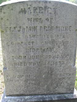
Harriet Ridgway Predmore
| Birth | : | 22 Jun 1839 Ocean County, New Jersey, USA |
| Death | : | 24 Nov 1899 Ocean County, New Jersey, USA |
| Burial | : | Mount Liberty Cemetery, Tanner, Gilmer County, USA |
| Coordinate | : | 39.0086390, -80.9616440 |
| Description | : | Harriet was the daughter of Lawrence and Charlotte Ridgway. She became the second wife of Benjamin Predmore, following the 1863 death of his first wife Louisa W. Birdsall. The 1850 Census for Union Township, NJ lists the following Household Members: Ridgway, Lawrence (53, M, farmer) Ridgway, Charlotte (42, F) Ridgway, Sarah (16, F) Ridgway, Mary (14, F) Ridgway, Harriet (10, F)<--THIS HARRIET Ridgway, Ann (7, F) Ridgway, Lucretia (4, F) Ridgway, Clayton (55, M) The 1870 Federal Census Ocean County, New Jersey lists the following household members, all living in Barnegat, NJ: Predmore, Benjamin - 45 - Merchant Predmore, Harriet - 31 - Housekeeper Predmore, Samuel B. - 13 Predmore, Jeremiah - 11 |
frequently asked questions (FAQ):
-
Where is Harriet Ridgway Predmore's memorial?
Harriet Ridgway Predmore's memorial is located at: Mount Liberty Cemetery, Tanner, Gilmer County, USA.
-
When did Harriet Ridgway Predmore death?
Harriet Ridgway Predmore death on 24 Nov 1899 in Ocean County, New Jersey, USA
-
Where are the coordinates of the Harriet Ridgway Predmore's memorial?
Latitude: 39.0086390
Longitude: -80.9616440
Family Members:
Spouse
Flowers:
Nearby Cemetories:
1. Mount Liberty Cemetery
Tanner, Gilmer County, USA
Coordinate: 39.0086390, -80.9616440
2. Roseville Church Cemetery
Gilmer County, USA
Coordinate: 39.0207880, -80.9547600
3. Cooper Family Cemetery
Tanner, Gilmer County, USA
Coordinate: 39.0083050, -80.9255920
4. Tanner Baptist Church Cemetery
Gilmer County, USA
Coordinate: 38.9814310, -80.9480630
5. Goff Cemetery
Burnt House, Ritchie County, USA
Coordinate: 39.0361530, -80.9774200
6. Good Shepherd Catholic Cemetery
Tanner, Gilmer County, USA
Coordinate: 38.9811830, -80.9447050
7. Cooper Chapel Cemetery
Tanner, Gilmer County, USA
Coordinate: 39.0057800, -80.9161500
8. New Mount Olive Cemetery
Burnt House, Ritchie County, USA
Coordinate: 39.0446100, -80.9340200
9. Trace Fork United Methodist Church Cemetery
Gilmer County, USA
Coordinate: 38.9743580, -81.0005560
10. Burnt House United Methodist Church Cemetery
Burnt House, Ritchie County, USA
Coordinate: 39.0487301, -80.9904470
11. Three Poplar Cemetery
Glenville, Gilmer County, USA
Coordinate: 38.9628600, -80.9445500
12. Mount Olive Cemetery
Burnt House, Ritchie County, USA
Coordinate: 39.0531006, -80.9257965
13. Wilson Cemetery
Lucerne, Gilmer County, USA
Coordinate: 38.9744900, -80.9013700
14. Abraham Bush Cemetery
Lucerne, Gilmer County, USA
Coordinate: 39.0184000, -80.8856806
15. Matthews Cemetery
Lucerne, Gilmer County, USA
Coordinate: 39.0112200, -80.8839100
16. N.H. Frederick Cemetery
Burnt House, Ritchie County, USA
Coordinate: 39.0525520, -81.0169120
17. Woodford Farm Cemetery
Lucerne, Gilmer County, USA
Coordinate: 38.9819600, -80.8880900
18. Nobe Cemetery
Nobe, Calhoun County, USA
Coordinate: 38.9813000, -81.0380300
19. Bush Cemetery
Gilmer County, USA
Coordinate: 39.0203018, -80.8783035
20. Holbert Cemetery
Gilmer County, USA
Coordinate: 38.9686012, -80.8944016
21. Union Baptist Church Cemetery
Lucerne, Gilmer County, USA
Coordinate: 39.0200800, -80.8779200
22. Newberne Cemetery
Gilmer County, USA
Coordinate: 39.0465510, -80.8910940
23. Riddle Cemetery
Gilmer County, USA
Coordinate: 38.9547005, -80.9049988
24. Pisgah United Methodist Church Cemetery
De Kalb, Gilmer County, USA
Coordinate: 38.9425160, -80.9219560


