
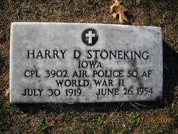
Harry David Stoneking
| Birth | : | 30 Jul 1919 Lucas County, Iowa, USA |
| Death | : | 26 Jun 1954 Scotts Bluff County, Nebraska, USA |
| Burial | : | Purewa Cemetery, Meadowbank, Auckland Council, New Zealand |
| Coordinate | : | -36.8674300, 174.8297900 |
| Inscription | : | CPL 3902 Air Police Sq. AF World War II |
| Description | : | OBITUARY THE CHARITON HERALD-PATRIOT Chariton, Iowa Thursday, July 8, 1954 HARRY DAVID STONEKING Harry David Stoneking, born July 30, 1919 in Lucas county, Iowa, and died in an automobile accident near Scottsbluff, Nebr., June 26, 1954, at the age of 34 years, 11 months and 27 days. He was a veteran of World War II, serving in the European theater. He was preceded in death by one sister, Gracie Pearl Stoneking, who died in infancy. He is survived by his father and mother, Mr. and Mrs. Charles Stoneking of Chariton, four brothers and four sisters,... Read More |
frequently asked questions (FAQ):
-
Where is Harry David Stoneking's memorial?
Harry David Stoneking's memorial is located at: Purewa Cemetery, Meadowbank, Auckland Council, New Zealand.
-
When did Harry David Stoneking death?
Harry David Stoneking death on 26 Jun 1954 in Scotts Bluff County, Nebraska, USA
-
Where are the coordinates of the Harry David Stoneking's memorial?
Latitude: -36.8674300
Longitude: 174.8297900
Family Members:
Parent

Siblings
Flowers:


Nearby Cemetories:
1. Purewa Cemetery
Meadowbank, Auckland Council, New Zealand
Coordinate: -36.8674300, 174.8297900
2. Ōrākei (Rautara St) Urupā
Orakei, Auckland Council, New Zealand
Coordinate: -36.8610770, 174.8188960
3. St. John’s College Graveyard
Saint Johns, Auckland Council, New Zealand
Coordinate: -36.8738169, 174.8416826
4. St. Thomas Churchyard
Tamaki, Auckland Council, New Zealand
Coordinate: -36.8675590, 174.8460560
5. Savage Memorial
Auckland, Auckland Council, New Zealand
Coordinate: -36.8462500, 174.8259300
6. Point England Presbyterian Cemetery
Point England, Auckland Council, New Zealand
Coordinate: -36.8823420, 174.8601550
7. St. Stephen's Churchyard
Auckland, Auckland Council, New Zealand
Coordinate: -36.8504860, 174.7899970
8. St Mark's Anglican Church Cemetery
Remuera, Auckland Council, New Zealand
Coordinate: -36.8729300, 174.7801600
9. St. Patrick's Roman Catholic Church Cemetery
Panmure, Auckland Council, New Zealand
Coordinate: -36.9029680, 174.8564960
10. St Matthias Churchyard
Panmure, Auckland Council, New Zealand
Coordinate: -36.9053300, 174.8577200
11. Royal New Zealand Navy Memorial
Devonport, Auckland Council, New Zealand
Coordinate: -36.8305900, 174.7898900
12. Mount Victoria Cemetery
Devonport, Auckland Council, New Zealand
Coordinate: -36.8252490, 174.7978140
13. Mount Eden Stockade Cemetery
Mount Eden, Auckland Council, New Zealand
Coordinate: -36.8678370, 174.7666430
14. Symonds Street Cemetery
Auckland, Auckland Council, New Zealand
Coordinate: -36.8582828, 174.7636628
15. Saint Andrew's Churchyard
Epsom, Auckland Council, New Zealand
Coordinate: -36.8937200, 174.7654100
16. Pakuranga Methodist Cemetery
Pakuranga, Auckland Council, New Zealand
Coordinate: -36.9054000, 174.8914900
17. Our Lady of the Assumption Catholic Church
Ōnehunga, Auckland Council, New Zealand
Coordinate: -36.9223690, 174.7884530
18. Onehunga Catholic Cemetery
Ōnehunga, Auckland Council, New Zealand
Coordinate: -36.9224360, 174.7884560
19. St. Peter's Anglican Cemetery
Ōnehunga, Auckland Council, New Zealand
Coordinate: -36.9227113, 174.7847550
20. Waikaraka Cemetery
Ōnehunga, Auckland Council, New Zealand
Coordinate: -36.9297140, 174.7967170
21. O'Neill's Point Cemetery
Belmont, Auckland Council, New Zealand
Coordinate: -36.8103002, 174.7812784
22. Howick Historical Village
Pakuranga, Auckland Council, New Zealand
Coordinate: -36.9067680, 174.9027080
23. Holy Trinity Memorial Park
Ōtāhūhū, Auckland Council, New Zealand
Coordinate: -36.9374510, 174.8448580
24. Otahuhu Public Cemetery
Ōtāhūhū, Auckland Council, New Zealand
Coordinate: -36.9377500, 174.8432390