
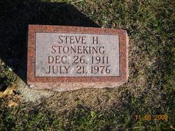
Steve Henry Stoneking
| Birth | : | 26 Dec 1911 Chariton, Lucas County, Iowa, USA |
| Death | : | 21 Jul 1976 Rock Springs, Sweetwater County, Wyoming, USA |
| Burial | : | Purewa Cemetery, Meadowbank, Auckland Council, New Zealand |
| Coordinate | : | -36.8674300, 174.8297900 |
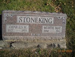
| Description | : | Husband of Gertrude McCabe. Son of Charles H. Stoneking and Murtie Mae Saunders OBITUARY THE CHARITON HERALD-PATRIOT Chariton, Iowa Thursday, August 19,, 1976 STONEKING Steve Henry Stoneking died July 21, 1976 at Rock Springs, Wyo. of a heart attack. He was born Dec. 26, 1911 at Chariton, Ia. to Charles H. and Murtie Mae Saunders Stoneking. He was married to Gertrude McCabe of Torrington, Wyo. He was an interior painter in Wyoming for 25-30 years. He is survived by sons: Steve Estel Stoneking and Gerald David Stoneking, both of Wyoming; brothers: Joe and Homer of Wyoming and Sid of Washington state; sisters: Ruth Dale of Chariton, Carrie... Read More |
frequently asked questions (FAQ):
-
Where is Steve Henry Stoneking's memorial?
Steve Henry Stoneking's memorial is located at: Purewa Cemetery, Meadowbank, Auckland Council, New Zealand.
-
When did Steve Henry Stoneking death?
Steve Henry Stoneking death on 21 Jul 1976 in Rock Springs, Sweetwater County, Wyoming, USA
-
Where are the coordinates of the Steve Henry Stoneking's memorial?
Latitude: -36.8674300
Longitude: 174.8297900
Family Members:
Parent

Spouse

Siblings
Flowers:


Nearby Cemetories:
1. Purewa Cemetery
Meadowbank, Auckland Council, New Zealand
Coordinate: -36.8674300, 174.8297900
2. Ōrākei (Rautara St) Urupā
Orakei, Auckland Council, New Zealand
Coordinate: -36.8610770, 174.8188960
3. St. John’s College Graveyard
Saint Johns, Auckland Council, New Zealand
Coordinate: -36.8738169, 174.8416826
4. St. Thomas Churchyard
Tamaki, Auckland Council, New Zealand
Coordinate: -36.8675590, 174.8460560
5. Savage Memorial
Auckland, Auckland Council, New Zealand
Coordinate: -36.8462500, 174.8259300
6. Point England Presbyterian Cemetery
Point England, Auckland Council, New Zealand
Coordinate: -36.8823420, 174.8601550
7. St. Stephen's Churchyard
Auckland, Auckland Council, New Zealand
Coordinate: -36.8504860, 174.7899970
8. St Mark's Anglican Church Cemetery
Remuera, Auckland Council, New Zealand
Coordinate: -36.8729300, 174.7801600
9. St. Patrick's Roman Catholic Church Cemetery
Panmure, Auckland Council, New Zealand
Coordinate: -36.9029680, 174.8564960
10. St Matthias Churchyard
Panmure, Auckland Council, New Zealand
Coordinate: -36.9053300, 174.8577200
11. Royal New Zealand Navy Memorial
Devonport, Auckland Council, New Zealand
Coordinate: -36.8305900, 174.7898900
12. Mount Victoria Cemetery
Devonport, Auckland Council, New Zealand
Coordinate: -36.8252490, 174.7978140
13. Mount Eden Stockade Cemetery
Mount Eden, Auckland Council, New Zealand
Coordinate: -36.8678370, 174.7666430
14. Symonds Street Cemetery
Auckland, Auckland Council, New Zealand
Coordinate: -36.8582828, 174.7636628
15. Saint Andrew's Churchyard
Epsom, Auckland Council, New Zealand
Coordinate: -36.8937200, 174.7654100
16. Pakuranga Methodist Cemetery
Pakuranga, Auckland Council, New Zealand
Coordinate: -36.9054000, 174.8914900
17. Our Lady of the Assumption Catholic Church
Ōnehunga, Auckland Council, New Zealand
Coordinate: -36.9223690, 174.7884530
18. Onehunga Catholic Cemetery
Ōnehunga, Auckland Council, New Zealand
Coordinate: -36.9224360, 174.7884560
19. St. Peter's Anglican Cemetery
Ōnehunga, Auckland Council, New Zealand
Coordinate: -36.9227113, 174.7847550
20. Waikaraka Cemetery
Ōnehunga, Auckland Council, New Zealand
Coordinate: -36.9297140, 174.7967170
21. O'Neill's Point Cemetery
Belmont, Auckland Council, New Zealand
Coordinate: -36.8103002, 174.7812784
22. Howick Historical Village
Pakuranga, Auckland Council, New Zealand
Coordinate: -36.9067680, 174.9027080
23. Holy Trinity Memorial Park
Ōtāhūhū, Auckland Council, New Zealand
Coordinate: -36.9374510, 174.8448580
24. Otahuhu Public Cemetery
Ōtāhūhū, Auckland Council, New Zealand
Coordinate: -36.9377500, 174.8432390