
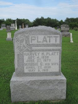

Harvey Hopping Platt
| Birth | : | 4 Oct 1838 Mount Vernon, Posey County, Indiana, USA |
| Death | : | 27 May 1873 Appanoose County, Iowa, USA |
| Burial | : | O'Neill's Point Cemetery, Belmont, Auckland Council, New Zealand |
| Coordinate | : | -36.8103002, 174.7812784 |
| Plot | : | Row 2 |
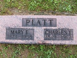
| Description | : | Same stone as Maggie C. Harvey H. Platt married Maggie C.(Unknown) at some time before the birth of Luella who was born on 4 Apr.,1865. They also had a son, Charles T. b.1869 d, 1962 and a daughter, Mary E. b.14 Aug.,1873 d.15 Jun.,1958. Note: They may have had other children, I don't know at this point. Jim |
frequently asked questions (FAQ):
-
Where is Harvey Hopping Platt's memorial?
Harvey Hopping Platt's memorial is located at: O'Neill's Point Cemetery, Belmont, Auckland Council, New Zealand.
-
When did Harvey Hopping Platt death?
Harvey Hopping Platt death on 27 May 1873 in Appanoose County, Iowa, USA
-
Where are the coordinates of the Harvey Hopping Platt's memorial?
Latitude: -36.8103002
Longitude: 174.7812784
Family Members:
Parent
Spouse

Children

Flowers:


Nearby Cemetories:
1. O'Neill's Point Cemetery
Belmont, Auckland Council, New Zealand
Coordinate: -36.8103002, 174.7812784
2. Mount Victoria Cemetery
Devonport, Auckland Council, New Zealand
Coordinate: -36.8252490, 174.7978140
3. Royal New Zealand Navy Memorial
Devonport, Auckland Council, New Zealand
Coordinate: -36.8305900, 174.7898900
4. St. Stephen's Churchyard
Auckland, Auckland Council, New Zealand
Coordinate: -36.8504860, 174.7899970
5. Pompallier Cemetery
Birkenhead, Auckland Council, New Zealand
Coordinate: -36.8036900, 174.7251200
6. Birkenhead-Glenfield Cemetery
Birkenhead, Auckland Council, New Zealand
Coordinate: -36.7989000, 174.7234700
7. Symonds Street Cemetery
Auckland, Auckland Council, New Zealand
Coordinate: -36.8582828, 174.7636628
8. Savage Memorial
Auckland, Auckland Council, New Zealand
Coordinate: -36.8462500, 174.8259300
9. Mount Eden Stockade Cemetery
Mount Eden, Auckland Council, New Zealand
Coordinate: -36.8678370, 174.7666430
10. Ōrākei (Rautara St) Urupā
Orakei, Auckland Council, New Zealand
Coordinate: -36.8610770, 174.8188960
11. St Mark's Anglican Church Cemetery
Remuera, Auckland Council, New Zealand
Coordinate: -36.8729300, 174.7801600
12. Purewa Cemetery
Meadowbank, Auckland Council, New Zealand
Coordinate: -36.8674300, 174.8297900
13. St. Thomas Churchyard
Tamaki, Auckland Council, New Zealand
Coordinate: -36.8675590, 174.8460560
14. St. John’s College Graveyard
Saint Johns, Auckland Council, New Zealand
Coordinate: -36.8738169, 174.8416826
15. St. Luke's Anglican Church Cemetery
Mount Albert, Auckland Council, New Zealand
Coordinate: -36.8785540, 174.7290400
16. Saint Andrew's Churchyard
Epsom, Auckland Council, New Zealand
Coordinate: -36.8937200, 174.7654100
17. Point England Presbyterian Cemetery
Point England, Auckland Council, New Zealand
Coordinate: -36.8823420, 174.8601550
18. North Shore Memorial Park
Auckland, Auckland Council, New Zealand
Coordinate: -36.7545800, 174.6838900
19. Holy Trinity Cemetery
Silverdale, Auckland Council, New Zealand
Coordinate: -36.7429008, 174.6940822
20. Hobsonville Church and Settlers' Cemetery
Hobsonville, Auckland Council, New Zealand
Coordinate: -36.8000500, 174.6551800
21. Albany Village Cemetery
Albany, Auckland Council, New Zealand
Coordinate: -36.7298900, 174.6972700
22. George Maxwell Memorial Cemetery
Avondale, Auckland Council, New Zealand
Coordinate: -36.8890320, 174.6849320
23. St. Patrick's Roman Catholic Church Cemetery
Panmure, Auckland Council, New Zealand
Coordinate: -36.9029680, 174.8564960
24. Saint Ninians Churchyard
Avondale, Auckland Council, New Zealand
Coordinate: -36.8994510, 174.6966690