

Mary Elizabeth Platt
| Birth | : | 14 Aug 1873 Appanoose County, Iowa, USA |
| Death | : | 15 Jun 1958 Appanoose County, Iowa, USA |
| Burial | : | O'Neill's Point Cemetery, Belmont, Auckland Council, New Zealand |
| Coordinate | : | -36.8103002, 174.7812784 |
| Plot | : | Row 2 |
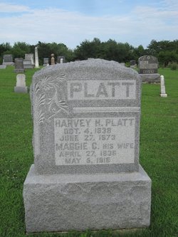
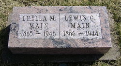
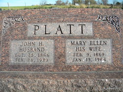
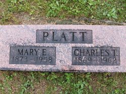
| Description | : | Shares stone with Charles T. Mary was the daughter of Harvey H. and Maggie C. (Unknown) Platt. She had at least one sister Luella M. (Platt) Main b.4 Apr.,1865 d,25 Nov.,1946 and a brother, Charles T. b. 1869 d. 1962. She married Jesse Ernest Smith on 8 Dec.,1895 in Appanoose Co., Ia. at the age of 22. Her only child, a daughter, was born on 13 Jan.,1898 when she was not quite 24 1/2. She is said to have told Jess that if she ever became pregnant, that she would leave him and evidentially she did. She divorced Jess on 31 May,1898... Read More |
frequently asked questions (FAQ):
-
Where is Mary Elizabeth Platt's memorial?
Mary Elizabeth Platt's memorial is located at: O'Neill's Point Cemetery, Belmont, Auckland Council, New Zealand.
-
When did Mary Elizabeth Platt death?
Mary Elizabeth Platt death on 15 Jun 1958 in Appanoose County, Iowa, USA
-
Where are the coordinates of the Mary Elizabeth Platt's memorial?
Latitude: -36.8103002
Longitude: 174.7812784
Family Members:
Parent

Spouse
Siblings
Children
Flowers:


Nearby Cemetories:
1. O'Neill's Point Cemetery
Belmont, Auckland Council, New Zealand
Coordinate: -36.8103002, 174.7812784
2. Mount Victoria Cemetery
Devonport, Auckland Council, New Zealand
Coordinate: -36.8252490, 174.7978140
3. Royal New Zealand Navy Memorial
Devonport, Auckland Council, New Zealand
Coordinate: -36.8305900, 174.7898900
4. St. Stephen's Churchyard
Auckland, Auckland Council, New Zealand
Coordinate: -36.8504860, 174.7899970
5. Pompallier Cemetery
Birkenhead, Auckland Council, New Zealand
Coordinate: -36.8036900, 174.7251200
6. Birkenhead-Glenfield Cemetery
Birkenhead, Auckland Council, New Zealand
Coordinate: -36.7989000, 174.7234700
7. Symonds Street Cemetery
Auckland, Auckland Council, New Zealand
Coordinate: -36.8582828, 174.7636628
8. Savage Memorial
Auckland, Auckland Council, New Zealand
Coordinate: -36.8462500, 174.8259300
9. Mount Eden Stockade Cemetery
Mount Eden, Auckland Council, New Zealand
Coordinate: -36.8678370, 174.7666430
10. Ōrākei (Rautara St) Urupā
Orakei, Auckland Council, New Zealand
Coordinate: -36.8610770, 174.8188960
11. St Mark's Anglican Church Cemetery
Remuera, Auckland Council, New Zealand
Coordinate: -36.8729300, 174.7801600
12. Purewa Cemetery
Meadowbank, Auckland Council, New Zealand
Coordinate: -36.8674300, 174.8297900
13. St. Thomas Churchyard
Tamaki, Auckland Council, New Zealand
Coordinate: -36.8675590, 174.8460560
14. St. John’s College Graveyard
Saint Johns, Auckland Council, New Zealand
Coordinate: -36.8738169, 174.8416826
15. St. Luke's Anglican Church Cemetery
Mount Albert, Auckland Council, New Zealand
Coordinate: -36.8785540, 174.7290400
16. Saint Andrew's Churchyard
Epsom, Auckland Council, New Zealand
Coordinate: -36.8937200, 174.7654100
17. Point England Presbyterian Cemetery
Point England, Auckland Council, New Zealand
Coordinate: -36.8823420, 174.8601550
18. North Shore Memorial Park
Auckland, Auckland Council, New Zealand
Coordinate: -36.7545800, 174.6838900
19. Holy Trinity Cemetery
Silverdale, Auckland Council, New Zealand
Coordinate: -36.7429008, 174.6940822
20. Hobsonville Church and Settlers' Cemetery
Hobsonville, Auckland Council, New Zealand
Coordinate: -36.8000500, 174.6551800
21. Albany Village Cemetery
Albany, Auckland Council, New Zealand
Coordinate: -36.7298900, 174.6972700
22. George Maxwell Memorial Cemetery
Avondale, Auckland Council, New Zealand
Coordinate: -36.8890320, 174.6849320
23. St. Patrick's Roman Catholic Church Cemetery
Panmure, Auckland Council, New Zealand
Coordinate: -36.9029680, 174.8564960
24. Saint Ninians Churchyard
Avondale, Auckland Council, New Zealand
Coordinate: -36.8994510, 174.6966690