

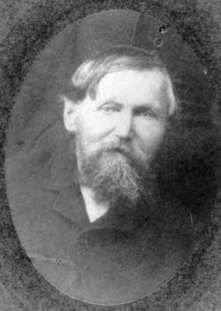
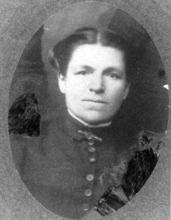
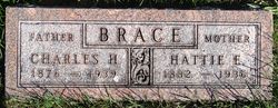
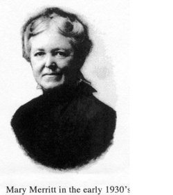
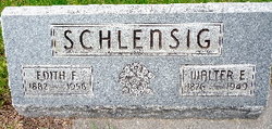
Hattie Elizabeth Schlensig Brace
| Birth | : | 21 Oct 1882 Willow Township, Monona County, Iowa, USA |
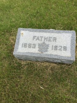
| Death | : | 12 Apr 1936 Dunlap, Harrison County, Iowa, USA |
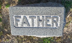
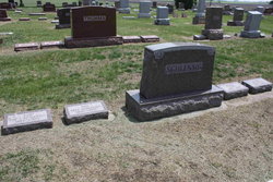
| Burial | : | East Liberty Cemetery, Green, Summit County, USA |
| Coordinate | : | 40.9743004, -81.4962997 |
| Plot | : | Block 14, Row 11 |
frequently asked questions (FAQ):
-
Where is Hattie Elizabeth Schlensig Brace's memorial?
Hattie Elizabeth Schlensig Brace's memorial is located at: East Liberty Cemetery, Green, Summit County, USA.
-
When did Hattie Elizabeth Schlensig Brace death?
Hattie Elizabeth Schlensig Brace death on 12 Apr 1936 in Dunlap, Harrison County, Iowa, USA
-
Where are the coordinates of the Hattie Elizabeth Schlensig Brace's memorial?
Latitude: 40.9743004
Longitude: -81.4962997
Family Members:
Parent
Spouse
Siblings

Children
Flowers:


Nearby Cemetories:
1. East Liberty Cemetery
Green, Summit County, USA
Coordinate: 40.9743004, -81.4962997
2. Pleasant Valley Cemetery
Akron, Summit County, USA
Coordinate: 41.0065002, -81.4931030
3. Klinefelter Cemetery
Green, Summit County, USA
Coordinate: 40.9383011, -81.4953995
4. Slovak Evangelical Cemetery
Krumroy, Summit County, USA
Coordinate: 41.0131989, -81.4675980
5. Greensburg Cemetery
Green, Summit County, USA
Coordinate: 40.9305992, -81.4792023
6. Ahavas Zedek Cemetery
Akron, Summit County, USA
Coordinate: 41.0199880, -81.5133590
7. Farband and Workmens Circle Cemetery
Akron, Summit County, USA
Coordinate: 41.0203840, -81.5146590
8. Anshe Sfard Cemetery
Akron, Summit County, USA
Coordinate: 41.0208570, -81.5153790
9. Lockwood Cemetery
Akron, Summit County, USA
Coordinate: 41.0003014, -81.5582962
10. Milheim Cemetery
Millheim, Summit County, USA
Coordinate: 41.0018005, -81.4345016
11. Holy Cross Cemetery
Akron, Summit County, USA
Coordinate: 41.0269012, -81.5231018
12. Kyser Cemetery
Barberton, Summit County, USA
Coordinate: 40.9775696, -81.5713272
13. Edwin Shaw Sanitarium Cemetery
South Akron, Summit County, USA
Coordinate: 41.0162010, -81.4332962
14. Jonathan Grable Burying Ground
Green, Summit County, USA
Coordinate: 40.9126010, -81.4691160
15. Greenlawn Cemetery
Uniontown, Stark County, USA
Coordinate: 40.9782982, -81.4103012
16. Old Lutheran Cemetery
Uniontown, Stark County, USA
Coordinate: 40.9772290, -81.4081710
17. Manchester Cemetery
New Franklin, Summit County, USA
Coordinate: 40.9352989, -81.5708008
18. Woods Cemetery
Uniontown, Stark County, USA
Coordinate: 40.9757996, -81.4008026
19. Lakewood Cemetery
Akron, Summit County, USA
Coordinate: 41.0314445, -81.5651169
20. Old Springfield Cemetery
Akron, Summit County, USA
Coordinate: 41.0501780, -81.4722920
21. Mount Hope Cemetery
Akron, Summit County, USA
Coordinate: 41.0490990, -81.5266037
22. Saint Augustine Cemetery
Akron, Summit County, USA
Coordinate: 41.0320015, -81.5687027
23. Grace Cathedral Cemetery
Akron, Summit County, USA
Coordinate: 41.0361958, -81.4297615
24. Tison Road Cemetery
Akron, Summit County, USA
Coordinate: 40.9995003, -81.3936996