
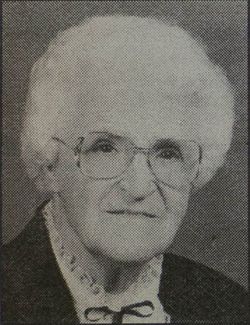

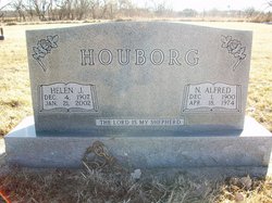
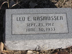
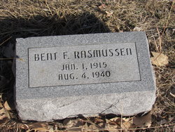
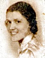
Helen Johanna Rasmussen Houborg
| Birth | : | 4 Dec 1907 Cozad, Dawson County, Nebraska, USA |
| Death | : | 21 Jan 2002 Cozad, Dawson County, Nebraska, USA |
| Burial | : | Newport General Cemetery, Newport, Telford and Wrekin Unitary Authority, England |
| Coordinate | : | 52.7656260, -2.3655840 |
| Plot | : | J3 |
frequently asked questions (FAQ):
-
Where is Helen Johanna Rasmussen Houborg's memorial?
Helen Johanna Rasmussen Houborg's memorial is located at: Newport General Cemetery, Newport, Telford and Wrekin Unitary Authority, England.
-
When did Helen Johanna Rasmussen Houborg death?
Helen Johanna Rasmussen Houborg death on 21 Jan 2002 in Cozad, Dawson County, Nebraska, USA
-
Where are the coordinates of the Helen Johanna Rasmussen Houborg's memorial?
Latitude: 52.7656260
Longitude: -2.3655840
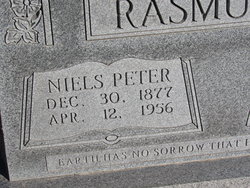
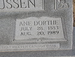
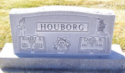
Family Members:
Parent
Spouse
Siblings

Children
Flowers:


Nearby Cemetories:
1. Newport General Cemetery
Newport, Telford and Wrekin Unitary Authority, England
Coordinate: 52.7656260, -2.3655840
2. St. Nicholas Churchyard
Newport, Telford and Wrekin Unitary Authority, England
Coordinate: 52.7696720, -2.3793420
3. St Andrews Churchyard
Church Aston, Telford and Wrekin Unitary Authority, England
Coordinate: 52.7577930, -2.3815770
4. Forton All Saints Churchyard
Newport, Telford and Wrekin Unitary Authority, England
Coordinate: 52.7876210, -2.3640430
5. Talbot Chapel
Longford, Telford and Wrekin Unitary Authority, England
Coordinate: 52.7627400, -2.4081500
6. Saint Michael and All Angels
Chetwynd, Telford and Wrekin Unitary Authority, England
Coordinate: 52.7887300, -2.3935160
7. Chetwynd Churchyard
Newport, Telford and Wrekin Unitary Authority, England
Coordinate: 52.7905280, -2.3916390
8. St. Peter Church
Edgmond, Telford and Wrekin Unitary Authority, England
Coordinate: 52.7699680, -2.4159730
9. Woodcote Parish Church
Woodcote, Telford and Wrekin Unitary Authority, England
Coordinate: 52.7358330, -2.3456640
10. St Michael and All Angels Churchyard
Lilleshall, Telford and Wrekin Unitary Authority, England
Coordinate: 52.7345610, -2.4032770
11. St Mary's, Moreton
Moreton, Stafford Borough, England
Coordinate: 52.7521490, -2.3021420
12. Lilleshall Abbey
Lilleshall, Telford and Wrekin Unitary Authority, England
Coordinate: 52.7247000, -2.3898000
13. Church of St Peter
Norbury, Stafford Borough, England
Coordinate: 52.8084000, -2.3184000
14. St. Matthew's Churchyard
Donnington Wood, Telford and Wrekin Unitary Authority, England
Coordinate: 52.7148135, -2.4308853
15. Tibberton All Saints
Tibberton, Telford and Wrekin Unitary Authority, England
Coordinate: 52.7800660, -2.4741020
16. St. Lawrence Churchyard
Gnosall, Stafford Borough, England
Coordinate: 52.7853010, -2.2533270
17. Telford Crematorium
Redhill, Telford and Wrekin Unitary Authority, England
Coordinate: 52.6950750, -2.3988090
18. Holy Trinity Church
Wrockwardine, Telford and Wrekin Unitary Authority, England
Coordinate: 52.7105800, -2.4476600
19. Wrockwardine Wood Methodist Graveyard
Wrockwardine, Telford and Wrekin Unitary Authority, England
Coordinate: 52.7076180, -2.4426530
20. St George's Churchyard
Oakengates, Telford and Wrekin Unitary Authority, England
Coordinate: 52.6952150, -2.4321740
21. St Michael and All Angels Churchyard
Adbaston, Stafford Borough, England
Coordinate: 52.8482630, -2.3545010
22. Wombridge Cemetery
Oakengates, Telford and Wrekin Unitary Authority, England
Coordinate: 52.7023940, -2.4579990
23. St. Editha's Parish Church Graveyard
Church Eaton, Stafford Borough, England
Coordinate: 52.7560690, -2.2259540
24. St Mary's & St Leonard's Church Burial Ground
Wombridge, Telford and Wrekin Unitary Authority, England
Coordinate: 52.7014856, -2.4585662