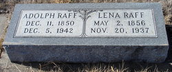
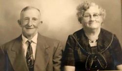
Helena “Lena” Boehme Raff
| Birth | : | 2 May 1856 |
| Death | : | 20 Nov 1937 |
| Burial | : | White Chapel Memorial Gardens, Gladstone, Clay County, USA |
| Coordinate | : | 39.2111015, -94.5372009 |
| Description | : | Mrs. Adolf Raff Dies Saturday; Funeral Tuesday Funeral services were held at the home at 1 o'clock Tuesday afternoon and at the Methodist church here at 2, for Mrs. Adolph Raff, who passed away Saturday noon, following a four week illness. The Rev. Enoch Nye, pastor of the Stark Valley Methodist Church officiated. Her death was attributed to bronchial pneumonia and influenza. Burial was made in Greenwood cemetery. Eighty years old, Mrs. Raff had lived on the place 10 miles west of Creighton, to which the family moved 35 years ago from Saunders county. Mrs. Raff, nee Lena Bohme, was born at Herman, Sheboygan county, Wisc.... Read More |
frequently asked questions (FAQ):
-
Where is Helena “Lena” Boehme Raff's memorial?
Helena “Lena” Boehme Raff's memorial is located at: White Chapel Memorial Gardens, Gladstone, Clay County, USA.
-
When did Helena “Lena” Boehme Raff death?
Helena “Lena” Boehme Raff death on 20 Nov 1937 in
-
Where are the coordinates of the Helena “Lena” Boehme Raff's memorial?
Latitude: 39.2111015
Longitude: -94.5372009
Family Members:
Spouse
Children
Flowers:
Nearby Cemetories:
1. White Chapel Memorial Gardens
Gladstone, Clay County, USA
Coordinate: 39.2111015, -94.5372009
2. Big Shoal Cemetery
Gladstone, Clay County, USA
Coordinate: 39.2098503, -94.5307312
3. Starks Cemetery
Clay County, USA
Coordinate: 39.2150210, -94.5464510
4. New Stark Cemetery
Gladstone, Clay County, USA
Coordinate: 39.2056007, -94.5291977
5. Fountain Waller Cemetery
Gladstone, Clay County, USA
Coordinate: 39.2078700, -94.5258500
6. Faubion Cemetery
Gladstone, Clay County, USA
Coordinate: 39.2246017, -94.5617981
7. Church of the Good Shepherd Episcopal Columbarium
Kansas City, Clay County, USA
Coordinate: 39.1852600, -94.5399800
8. McMurry United Methodist Church Columbarium
Kansas City, Clay County, USA
Coordinate: 39.1967380, -94.5066140
9. Antioch Community Church Columbarium
Kansas City, Clay County, USA
Coordinate: 39.1813695, -94.5483659
10. North Cross Methodist Church Memorial Garden
Kansas City, Clay County, USA
Coordinate: 39.1806410, -94.5635200
11. Pence Cemetery
Pleasant Valley, Clay County, USA
Coordinate: 39.2308006, -94.4899979
12. Craig Cemetery
Clay County, USA
Coordinate: 39.2477112, -94.5638733
13. Ricketts Cemetery
Kansas City, Clay County, USA
Coordinate: 39.1638718, -94.5430145
14. Rogers Cemetery
Clay County, USA
Coordinate: 39.1805992, -94.4903030
15. Crowley Cemetery
Kansas City, Clay County, USA
Coordinate: 39.1800003, -94.4897003
16. Davidson Cemetery
Kansas City, Clay County, USA
Coordinate: 39.2332993, -94.4794006
17. Gash Cemetery
Gashland, Clay County, USA
Coordinate: 39.2467613, -94.5848846
18. Roberts Cemetery
Clay County, USA
Coordinate: 39.1581600, -94.5235900
19. Old German Cemetery
Kansas City, Clay County, USA
Coordinate: 39.1885300, -94.6010100
20. Barry Cemetery
Barry, Clay County, USA
Coordinate: 39.2444000, -94.5963974
21. Adkins Family Cemetery
Liberty, Callaway County, USA
Coordinate: 39.2206840, -94.4579870
22. Adkins Family Cemetery
Liberty, Clay County, USA
Coordinate: 39.2206840, -94.4579870
23. Wilsons Cemetery
Barry, Clay County, USA
Coordinate: 39.2528800, -94.5982800
24. East Slope Memorial Gardens
Riverside, Platte County, USA
Coordinate: 39.1859320, -94.6124980

