
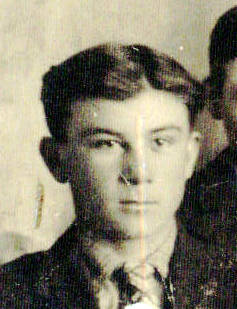
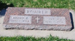

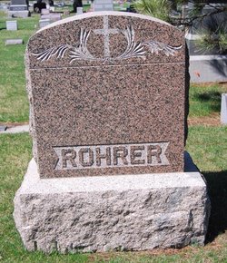
Henry Edward Rohrer
| Birth | : | 30 Jul 1894 Verdigre, Knox County, Nebraska, USA |
| Death | : | 7 Jul 1966 O'Neill, Holt County, Nebraska, USA |
| Burial | : | Lexington Quaker Cemetery, Lexington, Stark County, USA |
| Coordinate | : | 40.9617004, -81.1117020 |
frequently asked questions (FAQ):
-
Where is Henry Edward Rohrer's memorial?
Henry Edward Rohrer's memorial is located at: Lexington Quaker Cemetery, Lexington, Stark County, USA.
-
When did Henry Edward Rohrer death?
Henry Edward Rohrer death on 7 Jul 1966 in O'Neill, Holt County, Nebraska, USA
-
Where are the coordinates of the Henry Edward Rohrer's memorial?
Latitude: 40.9617004
Longitude: -81.1117020
Family Members:
Parent
Spouse
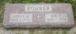

Siblings
Children

Flowers:


Nearby Cemetories:
1. Lexington Quaker Cemetery
Lexington, Stark County, USA
Coordinate: 40.9617004, -81.1117020
2. Wood Family Cemetery
Lexington, Stark County, USA
Coordinate: 40.9524870, -81.1407710
3. Dutch-Old German Church Cemetery
Atwater, Portage County, USA
Coordinate: 40.9886020, -81.1243970
4. Alliance City Cemetery
Alliance, Stark County, USA
Coordinate: 40.9309998, -81.1129990
5. Williamsport Cemetery
Alliance, Stark County, USA
Coordinate: 40.9325981, -81.0980988
6. Dutch Church Cemetery
Alliance, Stark County, USA
Coordinate: 40.9305650, -81.1055320
7. Limaville Cemetery
Stark County, USA
Coordinate: 40.9799995, -81.1500015
8. Temple Israel Cemetery
Alliance Junction, Mahoning County, USA
Coordinate: 40.9303400, -81.0778700
9. Deer Creek Quaker Cemetery
Stark County, USA
Coordinate: 40.9881020, -81.1722570
10. Science Hill Cemetery
Alliance, Stark County, USA
Coordinate: 40.9213930, -81.1639020
11. Saint Joseph Catholic Cemetery
Alliance, Stark County, USA
Coordinate: 40.9015670, -81.0893000
12. Atwater Cemetery
Atwater, Portage County, USA
Coordinate: 41.0203030, -81.1481420
13. Hayden Cemetery
Deerfield Township, Portage County, USA
Coordinate: 41.0031013, -81.0350037
14. Marlborough Quaker Burying Grounds
Alliance, Stark County, USA
Coordinate: 40.9507600, -81.2050000
15. Mount Union Cemetery
Alliance, Stark County, USA
Coordinate: 40.8891983, -81.1052017
16. Quaker Hill Cemetery
Sebring, Mahoning County, USA
Coordinate: 40.9158900, -81.0312000
17. West Beech Cemetery
Beechwood, Stark County, USA
Coordinate: 40.8860016, -81.1330032
18. North Benton Cemetery
North Benton, Mahoning County, USA
Coordinate: 40.9806100, -81.0120400
19. Marlboro Cemetery
Marlboro, Stark County, USA
Coordinate: 40.9645025, -81.2145472
20. Saint Pauls Reform Church Cemetery
Marlboro, Stark County, USA
Coordinate: 40.9796700, -81.2130800
21. Grandview Cemetery
Sebring, Mahoning County, USA
Coordinate: 40.9042015, -81.0310974
22. Hartzell Cemetery
Deerfield Township, Portage County, USA
Coordinate: 40.9965410, -81.0085490
23. Pentz Cemetery
Knox Township, Columbiana County, USA
Coordinate: 40.8870840, -81.0562440
24. Deerfield Cemetery
Deerfield, Portage County, USA
Coordinate: 41.0247220, -81.0341690