
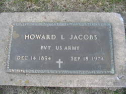

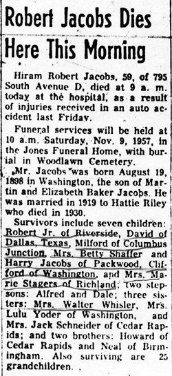
Howard Lee Jacobs
| Birth | : | 14 Dec 1894 Washington County, Iowa, USA |
| Death | : | 18 Sep 1974 Cedar Rapids, Linn County, Iowa, USA |
| Burial | : | SS Peter & Paul Churchyard, Little Gaddesden, Dacorum Borough, England |
| Coordinate | : | 51.8140340, -0.5538550 |
| Plot | : | D-6-76 |
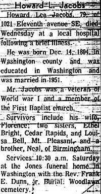
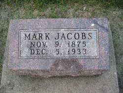
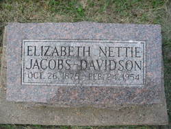
| Description | : | Howard was a son of Mark Martin Jacobs (1875-1933) & Elizabeth Antoinette Baker (1875-1954). Howard first married June Lambert on October 17, 1920 in Washington County, Iowa. No reported children. Howard then married some with the first name of "Irene." Details on this wife and marriage have not been determined. No reported children. Howard then married someone with the first name of Florence ______ (1908-1990) in 1951. Details on this wife and marriage have not been determined. No reported children. Howard was a veteran of World War I. |
frequently asked questions (FAQ):
-
Where is Howard Lee Jacobs's memorial?
Howard Lee Jacobs's memorial is located at: SS Peter & Paul Churchyard, Little Gaddesden, Dacorum Borough, England.
-
When did Howard Lee Jacobs death?
Howard Lee Jacobs death on 18 Sep 1974 in Cedar Rapids, Linn County, Iowa, USA
-
Where are the coordinates of the Howard Lee Jacobs's memorial?
Latitude: 51.8140340
Longitude: -0.5538550
Family Members:
Parent
Siblings

Flowers:


Nearby Cemetories:
1. SS Peter & Paul Churchyard
Little Gaddesden, Dacorum Borough, England
Coordinate: 51.8140340, -0.5538550
2. Ashridge Priory
Little Gaddesden, Dacorum Borough, England
Coordinate: 51.7990000, -0.5600000
3. St John the Baptist Churchyard
Aldbury, Dacorum Borough, England
Coordinate: 51.8025650, -0.6040510
4. St. Mary Magdalene Churchyard
Whipsnade, Central Bedfordshire Unitary Authority, England
Coordinate: 51.8510078, -0.5324191
5. St. Mary's Churchyard
Northchurch, Dacorum Borough, England
Coordinate: 51.7697820, -0.5891900
6. St. Mary's Churchyard
Pitstone, Aylesbury Vale District, England
Coordinate: 51.8251170, -0.6341170
7. Baptist Chapel Burial Ground
Northchurch, Dacorum Borough, England
Coordinate: 51.7680500, -0.5895400
8. St Mary the Virgin Churchyard
Edlesborough, Aylesbury Vale District, England
Coordinate: 51.8617700, -0.5918500
9. Saint Peters Church
Berkhamsted, Dacorum Borough, England
Coordinate: 51.7595990, -0.5616600
10. St. Michael and all Angels Churchyard
Berkhamsted, Dacorum Borough, England
Coordinate: 51.7590820, -0.5501120
11. St Mary the Virgin, Kensworth
Kensworth, Central Bedfordshire Unitary Authority, England
Coordinate: 51.8602233, -0.5037911
12. Rectory Lane Cemetery
Berkhamsted, Dacorum Borough, England
Coordinate: 51.7577780, -0.5607880
13. St Bartholomew Churchyard
Wigginton, Dacorum Borough, England
Coordinate: 51.7835990, -0.6351040
14. St. John the Baptist Churchyard
Markyate, Dacorum Borough, England
Coordinate: 51.8391900, -0.4658200
15. Kingshill Cemetery
Berkhamsted, Dacorum Borough, England
Coordinate: 51.7512770, -0.5743220
16. St Mary the Virgin Churchyard
Eaton Bray, Central Bedfordshire Unitary Authority, England
Coordinate: 51.8776980, -0.5655540
17. St Giles of Provence churchyard
Totternhoe, Central Bedfordshire Unitary Authority, England
Coordinate: 51.8778108, -0.5656137
18. New Mill Baptist Church Cemetery
Tring, Dacorum Borough, England
Coordinate: 51.8048400, -0.6604100
19. St. John the Evangelist Churchyard
Bourne End, Dacorum Borough, England
Coordinate: 51.7481590, -0.5296080
20. Akeman Street Baptist Churchyard
Tring, Dacorum Borough, England
Coordinate: 51.7929500, -0.6624700
21. Dunstable Cemetery
Dunstable, Central Bedfordshire Unitary Authority, England
Coordinate: 51.8831062, -0.5316300
22. St. Giles in the Woods Priory
Flamstead, Dacorum Borough, England
Coordinate: 51.8187400, -0.4374400
23. St. Mary's Churchyard
Hemel Hempstead, Dacorum Borough, England
Coordinate: 51.7590330, -0.4722730
24. Aley Green Cemetery
Slip End, Central Bedfordshire Unitary Authority, England
Coordinate: 51.8522500, -0.4496420