
| Birth | : | 1 Sep 1924 Fairfield, Jefferson County, Iowa, USA |
| Death | : | 20 Feb 2004 Milton, Van Buren County, Iowa, USA |
| Burial | : | Sheppey Cemetery, Sheerness, Swale Borough, England |
| Coordinate | : | 51.4232780, 0.7718320 |
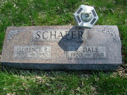
| Description | : | Howard was a son of Elmer Dale Schafer & Florence Howard. Howard married Elizabeth Mae Jacobs (1925-1997) on November 23, 1947 in Jefferson County, Iowa. They had eight identified children. |
frequently asked questions (FAQ):
-
Where is Howard Lee Schafer Sr.'s memorial?
Howard Lee Schafer Sr.'s memorial is located at: Sheppey Cemetery, Sheerness, Swale Borough, England.
-
When did Howard Lee Schafer Sr. death?
Howard Lee Schafer Sr. death on 20 Feb 2004 in Milton, Van Buren County, Iowa, USA
-
Where are the coordinates of the Howard Lee Schafer Sr.'s memorial?
Latitude: 51.4232780
Longitude: 0.7718320
Family Members:
Parent

Spouse

Siblings
Children
Flowers:


Nearby Cemetories:
1. Sheppey Cemetery
Sheerness, Swale Borough, England
Coordinate: 51.4232780, 0.7718320
2. Holy Trinity Churchyard
Queenborough, Swale Borough, England
Coordinate: 51.4174080, 0.7443560
3. Ss Mary and Sexburga New Churchyard
Minster on Sea, Swale Borough, England
Coordinate: 51.4235540, 0.8098720
4. Minster Abbey
Minster on Sea, Swale Borough, England
Coordinate: 51.4219320, 0.8119580
5. St James Churchyard
Grain, Medway Unitary Authority, England
Coordinate: 51.4585991, 0.7173300
6. All Saints Churchyard
Iwade, Swale Borough, England
Coordinate: 51.3787920, 0.7306550
7. All Saints Churchyard
Eastchurch, Swale Borough, England
Coordinate: 51.4068909, 0.8574320
8. Holy Trinity Churchyard
Milton Regis, Swale Borough, England
Coordinate: 51.3556700, 0.7401300
9. Garden of England Crematorium
Bobbing, Swale Borough, England
Coordinate: 51.3595330, 0.7179190
10. St Margaret of Antioch Churchyard
Lower Halstow, Swale Borough, England
Coordinate: 51.3752975, 0.6711660
11. St. Bartholomew's Churchyard
Bobbing, Swale Borough, England
Coordinate: 51.3537600, 0.7101420
12. St Giles Churchyard
Tonge, Swale Borough, England
Coordinate: 51.3424640, 0.7757790
13. Murston Cemetery
Sittingbourne, Swale Borough, England
Coordinate: 51.3424700, 0.7527100
14. Holy Trinity Church
Sittingbourne, Swale Borough, England
Coordinate: 51.3416000, 0.7316000
15. St Clement Churchyard
Leysdown, Swale Borough, England
Coordinate: 51.3970440, 0.9066620
16. St. Laurence's Churchyard
Bapchild, Swale Borough, England
Coordinate: 51.3330520, 0.7655020
17. St Mary the Virgin Churchyard
Upchurch, Swale Borough, England
Coordinate: 51.3764687, 0.6476030
18. St Mary the Virgin Churchyard
Newington, Swale Borough, England
Coordinate: 51.3567080, 0.6733120
19. St Mary Churchyard
Teynham, Swale Borough, England
Coordinate: 51.3377640, 0.8213570
20. Lower Stoke Methodist Chapelyard
Stoke, Medway Unitary Authority, England
Coordinate: 51.4537680, 0.6336680
21. Sittingbourne Cemetery
Sittingbourne, Swale Borough, England
Coordinate: 51.3345300, 0.7348000
22. All Saints Churchyard
Allhallows, Medway Unitary Authority, England
Coordinate: 51.4670950, 0.6417880
23. St Peter and St Paul Churchyard
Stoke, Medway Unitary Authority, England
Coordinate: 51.4452700, 0.6225300
24. Deerton Natural Burial Ground
Teynham, Swale Borough, England
Coordinate: 51.3344460, 0.8297850