
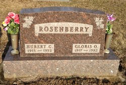
Hubert C. Rosenberry
| Birth | : | 7 Mar 1915 Auburn, DeKalb County, Indiana, USA |
| Death | : | 3 Oct 1972 Ann Arbor, Washtenaw County, Michigan, USA |
| Burial | : | Farmer Cemetery, Farmer, Defiance County, USA |
| Coordinate | : | 41.3903008, -84.6410980 |
| Description | : | Hubert C Rosenberry, 57, of 3720 Black Highway, died at 7:15 pm Tuesday evening in University Hospital, from fatal injuries suffered in an automobile accident on Occidental Highway two hours earlier. He was born March 7, 1915, in Auburn, Ind. Mr Rosenberry had been semi-retired since 1964, being employed by the State Highway Department. Surviving are four daughers, Mrs Ronald (Dora) Williams of Holt, Mrs Larry (Marcia) Cummings of Lansing, Mrs Douglas (Linda) Jenkins of Greenville, SC and Mrs Michael (Barbara) Nicholas of Jackson; 12 grandchildren. |
frequently asked questions (FAQ):
-
Where is Hubert C. Rosenberry's memorial?
Hubert C. Rosenberry's memorial is located at: Farmer Cemetery, Farmer, Defiance County, USA.
-
When did Hubert C. Rosenberry death?
Hubert C. Rosenberry death on 3 Oct 1972 in Ann Arbor, Washtenaw County, Michigan, USA
-
Where are the coordinates of the Hubert C. Rosenberry's memorial?
Latitude: 41.3903008
Longitude: -84.6410980
Family Members:
Parent
Spouse

Siblings
Flowers:


Nearby Cemetories:
1. Farmer Cemetery
Farmer, Defiance County, USA
Coordinate: 41.3903008, -84.6410980
2. Upper Lost Creek Cemetery
Farmer, Defiance County, USA
Coordinate: 41.3840000, -84.6700000
3. Kemp Cemetery
Defiance County, USA
Coordinate: 41.3703003, -84.6802979
4. Lost Creek Cemetery
Farmer, Defiance County, USA
Coordinate: 41.3553000, -84.6700000
5. Williams Center Cemetery
Williams Center, Williams County, USA
Coordinate: 41.4288902, -84.6125031
6. Tamarack Cemetery
Milford Township, Defiance County, USA
Coordinate: 41.4117012, -84.7089005
7. Zion Lutheran Church Cemetery
Defiance County, USA
Coordinate: 41.4261017, -84.7099991
8. Fetters Cemetery
Williams County, USA
Coordinate: 41.4519500, -84.6159900
9. Melbern-Neihardt Cemetery
Melbern, Williams County, USA
Coordinate: 41.4633600, -84.6416330
10. Lintz Cemetery
Ney, Defiance County, USA
Coordinate: 41.3760986, -84.5402985
11. Trinity Lutheran Cemetery
Ney, Defiance County, USA
Coordinate: 41.4016991, -84.5353012
12. Yackee Cemetery
Williams County, USA
Coordinate: 41.4707985, -84.6324997
13. Ney Cemetery
Ney, Defiance County, USA
Coordinate: 41.3856010, -84.5271988
14. Six Corners Cemetery
Hicksville, Defiance County, USA
Coordinate: 41.3213997, -84.7153015
15. Saint Johns Lutheran Cemetery
Sherwood, Defiance County, USA
Coordinate: 41.3092003, -84.5931015
16. Doud Cemetery
Ney, Defiance County, USA
Coordinate: 41.3811680, -84.5161110
17. Fountain Grove Cemetery
Bryan, Williams County, USA
Coordinate: 41.4572182, -84.5480576
18. Thomas Cemetery
Williams County, USA
Coordinate: 41.4769100, -84.6994240
19. Brown Cemetery
Bryan, Williams County, USA
Coordinate: 41.4822006, -84.5935974
20. Maple Grove Cemetery
Edgerton, Williams County, USA
Coordinate: 41.4435997, -84.7521973
21. St. Mary's Cemetery
Edgerton, Williams County, USA
Coordinate: 41.4441120, -84.7542700
22. Clarksville Cemetery
Edgerton, Williams County, USA
Coordinate: 41.4281006, -84.7677994
23. Auglaize Village Cemetery
Defiance, Defiance County, USA
Coordinate: 41.3399760, -84.5165610
24. Funk Cemetery
Defiance County, USA
Coordinate: 41.3396988, -84.5164032