
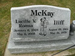
Iliff McKay
| Birth | : | 29 Aug 1924 Browning, Glacier County, Montana, USA |
| Death | : | 31 May 1979 Browning, Glacier County, Montana, USA |
| Burial | : | Holy Trinity Churchyard, Burrington, North Somerset Unitary Authority, England |
| Coordinate | : | 51.3307830, -2.7496010 |
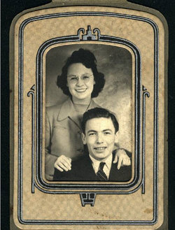
| Description | : | Iliff was born to Joseph (1876) and Isabelle(1892)McKay. There is a lot I don't know about Iliff. I should know. He was fairly influential in Reservation affairs. He was at varied times the Tribal Secretary, Tribal Treasurer, and elected member of the Blackfeet Tribal Council. He and Lucille built and operated the Junction Drive-Inn in Browning, which was a very popular eatery and hang-out for the community and young people. His wife and children's loss of husband and father in 1979 was very difficult for them and impacted their lives greatly.* *Additional info sent to me about Iliff... Read More |
frequently asked questions (FAQ):
-
Where is Iliff McKay's memorial?
Iliff McKay's memorial is located at: Holy Trinity Churchyard, Burrington, North Somerset Unitary Authority, England.
-
When did Iliff McKay death?
Iliff McKay death on 31 May 1979 in Browning, Glacier County, Montana, USA
-
Where are the coordinates of the Iliff McKay's memorial?
Latitude: 51.3307830
Longitude: -2.7496010
Family Members:
Spouse
Flowers:


Nearby Cemetories:
1. Holy Trinity Churchyard
Burrington, North Somerset Unitary Authority, England
Coordinate: 51.3307830, -2.7496010
2. Langford Chapelyard
Lower Langford, North Somerset Unitary Authority, England
Coordinate: 51.3434850, -2.7715630
3. St Mary's Church
Lower Langford, North Somerset Unitary Authority, England
Coordinate: 51.3399805, -2.7813469
4. St Andrew Churchyard
Blagdon, North Somerset Unitary Authority, England
Coordinate: 51.3275610, -2.7127710
5. St Michael and All Angels
Rowberrow, North Somerset Unitary Authority, England
Coordinate: 51.3240000, -2.7915000
6. Methodist Church Burial Ground
Churchill, North Somerset Unitary Authority, England
Coordinate: 51.3344140, -2.8000610
7. All Saints Churchyard
Wrington, North Somerset Unitary Authority, England
Coordinate: 51.3610710, -2.7657110
8. Shipham Cemetery
Shipham, Sedgemoor District, England
Coordinate: 51.3201930, -2.7992390
9. Wrington Chapel
Wrington, North Somerset Unitary Authority, England
Coordinate: 51.3651900, -2.7638270
10. St Leonard's Churchyard
Shipham, Sedgemoor District, England
Coordinate: 51.3130980, -2.8001830
11. Saint John the Baptist Churchyard
Churchill, North Somerset Unitary Authority, England
Coordinate: 51.3384750, -2.8092710
12. Christ Church Churchyard
Redhill, North Somerset Unitary Authority, England
Coordinate: 51.3657790, -2.7245240
13. St. Michael and All Angels Churchyard
Butcombe, North Somerset Unitary Authority, England
Coordinate: 51.3538470, -2.6973670
14. St. Bartholomew Churchyard
Ubley, Bath and North East Somerset Unitary Authority, England
Coordinate: 51.3214600, -2.6766900
15. Blessed Virgin Mary Churchyard
Nempnett Thrubwell, Bath and North East Somerset Unitary Authority, England
Coordinate: 51.3407790, -2.6721100
16. The Blessed Virgin Mary Churchyard
Nempnett Thrubwell, Bath and North East Somerset Unitary Authority, England
Coordinate: 51.3407560, -2.6720673
17. St. Michael Sanatorium Cemetery
Axbridge, Sedgemoor District, England
Coordinate: 51.2904100, -2.8056900
18. St Andrew Churchyard
Congresbury, North Somerset Unitary Authority, England
Coordinate: 51.3701100, -2.8121320
19. Winscombe and Sandford Cemetery
Winscombe, North Somerset Unitary Authority, England
Coordinate: 51.3223861, -2.8386889
20. Cheddar Baptist Burial Ground
Cheddar, Sedgemoor District, England
Coordinate: 51.2767330, -2.7792010
21. St. Andrew's Churchyard
Cheddar, Sedgemoor District, England
Coordinate: 51.2736740, -2.7761330
22. St. John the Baptist Churchyard
Axbridge, Sedgemoor District, England
Coordinate: 51.2876300, -2.8162900
23. Holy Trinity Churchyard
Cleeve, North Somerset Unitary Authority, England
Coordinate: 51.3908200, -2.7773600
24. St Michael the Archangel Churchyard
Compton Martin, Bath and North East Somerset Unitary Authority, England
Coordinate: 51.3107380, -2.6534510