
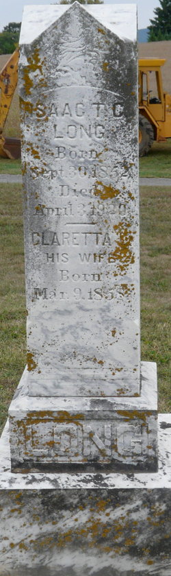
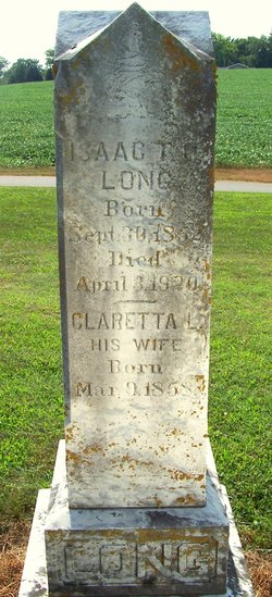
Isaac "Thomas" Calvin Long
| Birth | : | 30 Sep 1852 Middletown, Frederick County, Maryland, USA |
| Death | : | 3 Apr 1920 Middletown, Frederick County, Maryland, USA |
| Burial | : | Holy Trinity Churchyard, Burrington, North Somerset Unitary Authority, England |
| Coordinate | : | 51.3307830, -2.7496010 |
| Description | : | Stone names wife, Claretta L, but she does not appear to be buried here. |
frequently asked questions (FAQ):
-
Where is Isaac "Thomas" Calvin Long's memorial?
Isaac "Thomas" Calvin Long's memorial is located at: Holy Trinity Churchyard, Burrington, North Somerset Unitary Authority, England.
-
When did Isaac "Thomas" Calvin Long death?
Isaac "Thomas" Calvin Long death on 3 Apr 1920 in Middletown, Frederick County, Maryland, USA
-
Where are the coordinates of the Isaac "Thomas" Calvin Long's memorial?
Latitude: 51.3307830
Longitude: -2.7496010
Family Members:
Parent
Spouse
Siblings

Children


Nearby Cemetories:
1. Holy Trinity Churchyard
Burrington, North Somerset Unitary Authority, England
Coordinate: 51.3307830, -2.7496010
2. Langford Chapelyard
Lower Langford, North Somerset Unitary Authority, England
Coordinate: 51.3434850, -2.7715630
3. St Mary's Church
Lower Langford, North Somerset Unitary Authority, England
Coordinate: 51.3399805, -2.7813469
4. St Andrew Churchyard
Blagdon, North Somerset Unitary Authority, England
Coordinate: 51.3275610, -2.7127710
5. St Michael and All Angels
Rowberrow, North Somerset Unitary Authority, England
Coordinate: 51.3240000, -2.7915000
6. Methodist Church Burial Ground
Churchill, North Somerset Unitary Authority, England
Coordinate: 51.3344140, -2.8000610
7. All Saints Churchyard
Wrington, North Somerset Unitary Authority, England
Coordinate: 51.3610710, -2.7657110
8. Shipham Cemetery
Shipham, Sedgemoor District, England
Coordinate: 51.3201930, -2.7992390
9. Wrington Chapel
Wrington, North Somerset Unitary Authority, England
Coordinate: 51.3651900, -2.7638270
10. St Leonard's Churchyard
Shipham, Sedgemoor District, England
Coordinate: 51.3130980, -2.8001830
11. Saint John the Baptist Churchyard
Churchill, North Somerset Unitary Authority, England
Coordinate: 51.3384750, -2.8092710
12. Christ Church Churchyard
Redhill, North Somerset Unitary Authority, England
Coordinate: 51.3657790, -2.7245240
13. St. Michael and All Angels Churchyard
Butcombe, North Somerset Unitary Authority, England
Coordinate: 51.3538470, -2.6973670
14. St. Bartholomew Churchyard
Ubley, Bath and North East Somerset Unitary Authority, England
Coordinate: 51.3214600, -2.6766900
15. Blessed Virgin Mary Churchyard
Nempnett Thrubwell, Bath and North East Somerset Unitary Authority, England
Coordinate: 51.3407790, -2.6721100
16. The Blessed Virgin Mary Churchyard
Nempnett Thrubwell, Bath and North East Somerset Unitary Authority, England
Coordinate: 51.3407560, -2.6720673
17. St. Michael Sanatorium Cemetery
Axbridge, Sedgemoor District, England
Coordinate: 51.2904100, -2.8056900
18. St Andrew Churchyard
Congresbury, North Somerset Unitary Authority, England
Coordinate: 51.3701100, -2.8121320
19. Winscombe and Sandford Cemetery
Winscombe, North Somerset Unitary Authority, England
Coordinate: 51.3223861, -2.8386889
20. Cheddar Baptist Burial Ground
Cheddar, Sedgemoor District, England
Coordinate: 51.2767330, -2.7792010
21. St. Andrew's Churchyard
Cheddar, Sedgemoor District, England
Coordinate: 51.2736740, -2.7761330
22. St. John the Baptist Churchyard
Axbridge, Sedgemoor District, England
Coordinate: 51.2876300, -2.8162900
23. Holy Trinity Churchyard
Cleeve, North Somerset Unitary Authority, England
Coordinate: 51.3908200, -2.7773600
24. St Michael the Archangel Churchyard
Compton Martin, Bath and North East Somerset Unitary Authority, England
Coordinate: 51.3107380, -2.6534510