
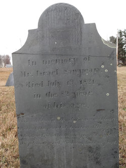
Israel Sawyer Sawyer
| Birth | : | 17 Oct 1779 Newburyport, Essex County, Massachusetts, USA |
| Death | : | 26 Oct 1848 South Hampton, Rockingham County, New Hampshire, USA |
| Burial | : | Spalding Cemetery, Spalding, South Holland District, England |
| Coordinate | : | 52.7954960, -0.1519390 |
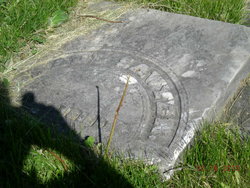
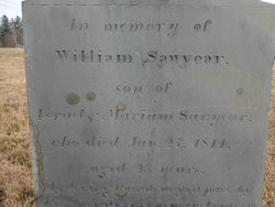
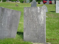
| Description | : | broken headstone very difficult to read This memorial for Israel Sawyer was correctly placed in Old South Hampton Cemetery. The cemetery was created in 2012. An earlier (2010) memorial for Israel Sawyer that was marked cemetery unknown was moved into the cemetery after this memorial was created. Per FAG guidelines: In regard to duplicates, a memorial with a correct known burial location will always be preferred over an unknown burial location. Therefore, this memorial should have not been moved, and the earlier moved here from 'unknown' should have been deleted. |
frequently asked questions (FAQ):
-
Where is Israel Sawyer Sawyer's memorial?
Israel Sawyer Sawyer's memorial is located at: Spalding Cemetery, Spalding, South Holland District, England.
-
When did Israel Sawyer Sawyer death?
Israel Sawyer Sawyer death on 26 Oct 1848 in South Hampton, Rockingham County, New Hampshire, USA
-
Where are the coordinates of the Israel Sawyer Sawyer's memorial?
Latitude: 52.7954960
Longitude: -0.1519390
Family Members:
Parent
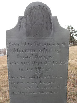
Spouse

Siblings
Children

Flowers:


Nearby Cemetories:
1. Spalding Cemetery
Spalding, South Holland District, England
Coordinate: 52.7954960, -0.1519390
2. St Paul's Churchyard
Spalding, South Holland District, England
Coordinate: 52.7969559, -0.1305557
3. St. Mary's Churchyard
Pinchbeck, South Holland District, England
Coordinate: 52.8135340, -0.1589220
4. St. Laurence Churchyard
Surfleet, South Holland District, England
Coordinate: 52.8369500, -0.1436110
5. St Bartholomew's Church West Pinchbeck
Pinchbeck, South Holland District, England
Coordinate: 52.8080873, -0.2216285
6. Surfleet Cemetery
Surfleet, South Holland District, England
Coordinate: 52.8391670, -0.1383330
7. St. Mary's Cemetery
Weston, South Holland District, England
Coordinate: 52.8078662, -0.0809039
8. South Lincolnshire Crematorium
Surfleet, South Holland District, England
Coordinate: 52.8451100, -0.1475110
9. All Saints Churchyard
Moulton, South Holland District, England
Coordinate: 52.7990056, -0.0629691
10. Moulton Cemetery
Moulton, South Holland District, England
Coordinate: 52.8017000, -0.0632400
11. St Gilbert and St Hugh Churchyard
Gosberton Clough, South Holland District, England
Coordinate: 52.8518081, -0.2166268
12. St. Mary's Churchyard
Whaplode, South Holland District, England
Coordinate: 52.7974840, -0.0385520
13. Gosberton Baptist Church
Gosberton, South Holland District, England
Coordinate: 52.8651820, -0.1533940
14. Gosberton Cemetery
Gosberton, South Holland District, England
Coordinate: 52.8659400, -0.1623000
15. St. Peter and St. Paul Churchyard
Gosberton, South Holland District, England
Coordinate: 52.8690870, -0.1629740
16. Whaplode Cemetery
Whaplode, South Holland District, England
Coordinate: 52.8016190, -0.0281347
17. St. Margaret's Churchyard
Quadring, South Holland District, England
Coordinate: 52.8903400, -0.1819700
18. All Saints Churchyard
Holbeach, South Holland District, England
Coordinate: 52.8036140, 0.0142530
19. Holbeach Cemetery
Holbeach, South Holland District, England
Coordinate: 52.8062100, 0.0171500
20. St. John's Churchyard
Holbeach, South Holland District, England
Coordinate: 52.7457510, -0.0024000
21. All Saints Churchyard
Fosdyke, Boston Borough, England
Coordinate: 52.8811100, -0.0469440
22. Fosdyke Village Cemetery
Fosdyke, Boston Borough, England
Coordinate: 52.8808330, -0.0447220
23. Sutterton Village Cemetery
Sutterton, Boston Borough, England
Coordinate: 52.8994440, -0.0900000
24. St. John the Baptist Churchyard
Whaplode Drove, South Holland District, England
Coordinate: 52.7034435, -0.0476688