
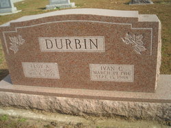
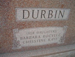
Ivan C. Durbin
| Birth | : | 19 Mar 1916 Emerson, Mills County, Iowa, USA |
| Death | : | 15 Sep 1988 Council Bluffs, Pottawattamie County, Iowa, USA |
| Burial | : | St Michael and All Angels Summertown, Oxford, City of Oxford, England |
| Coordinate | : | 51.7796280, -1.2643940 |
| Plot | : | 3rd Addition, Lot 26 |
| Description | : | Memorial Services Held for Ivan C. Durbin Ivan C. Durbin was born on March 19, 1916 in Mills County, Iowa in Indian Creek Township near Emerson. His parents were Orville and Vesta (Cheney) Durbin. On June 7,1936, he married Floy Beachler in Reynolds, NE. Ivan lived and farmed all his life on a century farm near Emerson, Iowa. He was a member and deacon of the Emerson Baptist Church. He was a member of the Emerson Masonic Lodge and the Order of Eastern Star, a former member of the North Grove School Board and the Emerson Town Council. Ivan also served as a member... Read More |
frequently asked questions (FAQ):
-
Where is Ivan C. Durbin's memorial?
Ivan C. Durbin's memorial is located at: St Michael and All Angels Summertown, Oxford, City of Oxford, England.
-
When did Ivan C. Durbin death?
Ivan C. Durbin death on 15 Sep 1988 in Council Bluffs, Pottawattamie County, Iowa, USA
-
Where are the coordinates of the Ivan C. Durbin's memorial?
Latitude: 51.7796280
Longitude: -1.2643940
Family Members:
Parent

Spouse
Siblings
Children
Flowers:


Nearby Cemetories:
1. St Michael and All Angels Summertown
Oxford, City of Oxford, England
Coordinate: 51.7796280, -1.2643940
2. St. Peter Churchyard
Wolvercote, City of Oxford, England
Coordinate: 51.7848300, -1.2811100
3. Wolvercote Cemetery
Oxford, City of Oxford, England
Coordinate: 51.7913666, -1.2721500
4. St. Nicholas Churchyard
Old Marston, City of Oxford, England
Coordinate: 51.7761340, -1.2373130
5. St. Sepulchres Cemetery
Oxford, City of Oxford, England
Coordinate: 51.7611110, -1.2694440
6. Elsfield Road Cemetery
Old Marston, City of Oxford, England
Coordinate: 51.7752940, -1.2332640
7. St Paul's Oxford Cemetery
Oxford, City of Oxford, England
Coordinate: 51.7594590, -1.2648470
8. St Giles Churchyard
Oxford, City of Oxford, England
Coordinate: 51.7591660, -1.2605170
9. Saint Barnabas Church
Oxford, City of Oxford, England
Coordinate: 51.7579620, -1.2697600
10. Godstow Abbey Ruins
Oxford, City of Oxford, England
Coordinate: 51.7784060, -1.2998170
11. Saint Margaret of Antioch
City of Oxford, England
Coordinate: 51.7690340, -1.2975900
12. Mansfield College Chapel
Oxford, City of Oxford, England
Coordinate: 51.7576410, -1.2523340
13. Blackfriars
Oxford, City of Oxford, England
Coordinate: 51.7561210, -1.2602060
14. St Johns College
Oxford, City of Oxford, England
Coordinate: 51.7560820, -1.2589910
15. Wadham College Chapel
Oxford, City of Oxford, England
Coordinate: 51.7560700, -1.2540350
16. Martyrs' Memorial
Oxford, City of Oxford, England
Coordinate: 51.7550900, -1.2590100
17. Trinity College Chapel
Oxford, City of Oxford, England
Coordinate: 51.7552360, -1.2569620
18. Austin Friars Church
Oxford, City of Oxford, England
Coordinate: 51.7553710, -1.2541550
19. St. Mary Magdalene's Churchyard
Oxford, City of Oxford, England
Coordinate: 51.7546250, -1.2588340
20. Balliol College Chapel
Oxford, City of Oxford, England
Coordinate: 51.7547800, -1.2572240
21. Rewley Abbey
Oxford, City of Oxford, England
Coordinate: 51.7543810, -1.2675170
22. Saint Cross Church
Oxford, City of Oxford, England
Coordinate: 51.7561880, -1.2479120
23. St. Cross Churchyard
Holywell, City of Oxford, England
Coordinate: 51.7558380, -1.2479690
24. St. Michael at the North Gate Church
Oxford, City of Oxford, England
Coordinate: 51.7537210, -1.2583950