
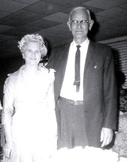
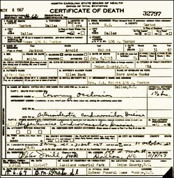
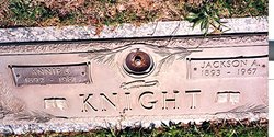
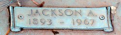
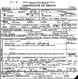
Jackson Arnold Knight
| Birth | : | 6 Jan 1893 Union County, North Carolina, USA |
| Death | : | 31 Oct 1967 Dallas, Gaston County, North Carolina, USA |
| Burial | : | St. Michael and All Angels Churchyard, Horton, Staffordshire Moorlands District, England |
| Coordinate | : | 53.1135330, -2.0879040 |
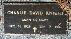
| Description | : | Jackson was the son of William Alfred Knight and Ellen Mack. He married Mary "Annie" Jane Hooks, daughter of Robert Hooks and Sarah Jane Gaddy, 28 Apr 1912 in Union County, North Carolina. Nine children ware born to this marriage; Clarence Robert (1912 - 2000), Winfred Arnold (1914 - 1988), Albert Jackson (1917 - 1983), William Clifton (1919 - 1920), Ruby Kathleen (1921 - 2008), Sarah Edna (Born 1924), Willace Van (Born 1927), Charlie David (1929- 1986) and Wilma Shirley (Born 1933. |
frequently asked questions (FAQ):
-
Where is Jackson Arnold Knight's memorial?
Jackson Arnold Knight's memorial is located at: St. Michael and All Angels Churchyard, Horton, Staffordshire Moorlands District, England.
-
When did Jackson Arnold Knight death?
Jackson Arnold Knight death on 31 Oct 1967 in Dallas, Gaston County, North Carolina, USA
-
Where are the coordinates of the Jackson Arnold Knight's memorial?
Latitude: 53.1135330
Longitude: -2.0879040
Family Members:

Spouse

Siblings
Children
Flowers:


Nearby Cemetories:
1. St. Michael and All Angels Churchyard
Horton, Staffordshire Moorlands District, England
Coordinate: 53.1135330, -2.0879040
2. St. Michael's Churchyard Extension
Horton, Staffordshire Moorlands District, England
Coordinate: 53.1139430, -2.0878020
3. St Chad Churchyard
Longsdon, Staffordshire Moorlands District, England
Coordinate: 53.0887220, -2.0625850
4. Christ Church Churchyard
Biddulph Moor, Staffordshire Moorlands District, England
Coordinate: 53.1220780, -2.1402320
5. St. Luke's Churchyard
Endon, Staffordshire Moorlands District, England
Coordinate: 53.0812200, -2.1086100
6. St Edward the Confessor Churchyard
Leek, Staffordshire Moorlands District, England
Coordinate: 53.1068190, -2.0266150
7. Leek Cemetery
Leek, Staffordshire Moorlands District, England
Coordinate: 53.1000880, -2.0248680
8. St Luke Churchyard
Leek, Staffordshire Moorlands District, England
Coordinate: 53.1061400, -2.0191430
9. St Lawrence Churchyard
Rushton Spencer, Staffordshire Moorlands District, England
Coordinate: 53.1556630, -2.0996440
10. St Anne Churchyard
Brown Edge, Staffordshire Moorlands District, England
Coordinate: 53.0832490, -2.1429880
11. St. Lawrence Churchyard
Biddulph, Staffordshire Moorlands District, England
Coordinate: 53.1281320, -2.1659070
12. St Edwards Lawn Cemetery
Cheddleton, Staffordshire Moorlands District, England
Coordinate: 53.0744437, -2.0385063
13. Buxton Road Cemetery
Leek, Staffordshire Moorlands District, England
Coordinate: 53.1154780, -2.0029690
14. St Edward the Confessor Churchyard
Cheddleton, Staffordshire Moorlands District, England
Coordinate: 53.0689530, -2.0448230
15. St. Matthew's Churchyard
Meerbrook, Staffordshire Moorlands District, England
Coordinate: 53.1446350, -2.0177810
16. St Chad Churchyard
Bagnall, Staffordshire Moorlands District, England
Coordinate: 53.0558430, -2.1082770
17. St Bartholomew Churchyard
Norton in the Moors, Stoke-on-Trent Unitary Authority, England
Coordinate: 53.0604630, -2.1595270
18. St. Philip and St. James Churchyard
Milton, Stoke-on-Trent Unitary Authority, England
Coordinate: 53.0503730, -2.1403780
19. St Thomas Churchyard
Mow Cop, Newcastle-Under-Lyme Borough, England
Coordinate: 53.1127280, -2.2101350
20. St John the Baptist Churchyard
Wetley Rocks, Staffordshire Moorlands District, England
Coordinate: 53.0409100, -2.0555020
21. Carmountside Cemetery and Crematorium
Milton, Stoke-on-Trent Unitary Authority, England
Coordinate: 53.0449570, -2.1394910
22. St. James the Apostle Churchyard
Newchapel, Newcastle-Under-Lyme Borough, England
Coordinate: 53.0874630, -2.2069790
23. St. Mary the Virgin Churchyard
Bosley, Cheshire East Unitary Authority, England
Coordinate: 53.1871110, -2.1241630
24. St. Michael's Churchyard
Wincle, Cheshire East Unitary Authority, England
Coordinate: 53.1933190, -2.0620740