
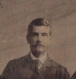

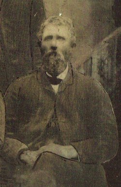
Jacob Bower
| Birth | : | 1 Mar 1849 Perry County, Ohio, USA |
| Death | : | 22 Mar 1929 Thorncreek Township, Whitley County, Indiana, USA |
| Burial | : | Sunset View Cemetery, El Cerrito, Contra Costa County, USA |
| Coordinate | : | 37.9077721, -122.2871017 |
| Plot | : | Hively-7-11-1 |
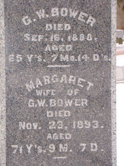
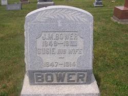
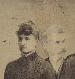
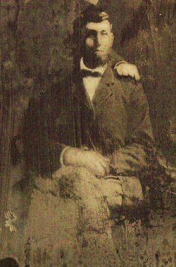
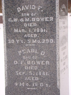
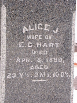
| Description | : | Jacob Bower was the son of George W. Bower and Margaret Alabaugh. He married Susie Sutton on Oct. 24 1871. They had a son Claude A Bower. She passed on in 1914. He next married the widow Melissa M (Joslin) Brubaker on 18 May 1915 in Whitley Co., Indiana. He was my great grand uncle. |
frequently asked questions (FAQ):
-
Where is Jacob Bower's memorial?
Jacob Bower's memorial is located at: Sunset View Cemetery, El Cerrito, Contra Costa County, USA.
-
When did Jacob Bower death?
Jacob Bower death on 22 Mar 1929 in Thorncreek Township, Whitley County, Indiana, USA
-
Where are the coordinates of the Jacob Bower's memorial?
Latitude: 37.9077721
Longitude: -122.2871017
Family Members:
Parent

Spouse
Siblings
Flowers:


Nearby Cemetories:
1. Sunset View Cemetery
El Cerrito, Contra Costa County, USA
Coordinate: 37.9077721, -122.2871017
2. Golden Gate Mausoleum and Columbaria
El Cerrito, Contra Costa County, USA
Coordinate: 37.9073150, -122.2857220
3. Northbrae Community Church Columbarium
Berkeley, Alameda County, USA
Coordinate: 37.8905500, -122.2763200
4. Golden Gate Fields
Albany, Alameda County, USA
Coordinate: 37.8854000, -122.3117000
5. Salesian Cemetery
Richmond, Contra Costa County, USA
Coordinate: 37.9532650, -122.3401230
6. Saint Joseph Catholic Cemetery
San Pablo, Contra Costa County, USA
Coordinate: 37.9612700, -122.3336600
7. Saint Pauls Cemetery (Defunct)
San Pablo, Contra Costa County, USA
Coordinate: 37.9563332, -122.3430099
8. Rolling Hills Memorial Park
Richmond, Contra Costa County, USA
Coordinate: 37.9756012, -122.3146973
9. Saint Mary's Cemetery
Oakland, Alameda County, USA
Coordinate: 37.8349991, -122.2418976
10. Home of Eternity Cemetery
Oakland, Alameda County, USA
Coordinate: 37.8322970, -122.2448270
11. Chapel of the Chimes Columbarium and Mausoleum
Oakland, Alameda County, USA
Coordinate: 37.8318863, -122.2456894
12. Chapel of Memories Columbarium
Oakland, Alameda County, USA
Coordinate: 37.8310471, -122.2480927
13. Gan Shalom Cemetery
Contra Costa County, USA
Coordinate: 37.9528122, -122.1975098
14. Mountain View Cemetery
Oakland, Alameda County, USA
Coordinate: 37.8327600, -122.2395200
15. Saint Stephens Episcopal Church Memorial Garden
Orinda, Contra Costa County, USA
Coordinate: 37.8982650, -122.1729170
16. Cathedral of Christ the Light Mausoleum
Oakland, Alameda County, USA
Coordinate: 37.8105316, -122.2633896
17. Lafayette-Orinda Presbyterian Church Garden
Contra Costa County, USA
Coordinate: 37.8866040, -122.1606950
18. Yerba Buena Island Cemetery (Defunct)
San Francisco, San Francisco County, USA
Coordinate: 37.8127420, -122.3707880
19. Saint Paul Lutheran Church
Oakland, Alameda County, USA
Coordinate: 37.8020820, -122.2222780
20. Angel Island Cemetery (defunct)
Tiburon, Marin County, USA
Coordinate: 37.8621830, -122.4325920
21. Home of Peace Cemetery
Oakland, Alameda County, USA
Coordinate: 37.7790604, -122.2036285
22. First Street Cemetery (Defunct)
San Francisco, San Francisco County, USA
Coordinate: 37.7906170, -122.3991770
23. Muir-Strentzel Hanna Cemetery
Martinez, Contra Costa County, USA
Coordinate: 37.9784393, -122.1232681
24. Bush Street Cemetery (Defunct)
San Francisco, San Francisco County, USA
Coordinate: 37.7907950, -122.4011960