
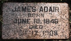
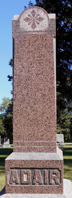
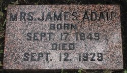
James Adair
| Birth | : | 18 Jun 1846 Mono, Dufferin County, Ontario, Canada |
| Death | : | 17 Feb 1909 Polk County, Minnesota, USA |
| Burial | : | Hardin Township Cemetery, McClelland, Pottawattamie County, USA |
| Coordinate | : | 41.2949982, -95.6513977 |
frequently asked questions (FAQ):
-
Where is James Adair's memorial?
James Adair's memorial is located at: Hardin Township Cemetery, McClelland, Pottawattamie County, USA.
-
When did James Adair death?
James Adair death on 17 Feb 1909 in Polk County, Minnesota, USA
-
Where are the coordinates of the James Adair's memorial?
Latitude: 41.2949982
Longitude: -95.6513977
Family Members:
Parent

Spouse
Siblings
Children
Flowers:


Nearby Cemetories:
1. Hardin Township Cemetery
McClelland, Pottawattamie County, USA
Coordinate: 41.2949982, -95.6513977
2. Pottawattamie County Home Cemetery
McClelland, Pottawattamie County, USA
Coordinate: 41.3269400, -95.6691738
3. Saint Paul Lutheran Cemetery
Treynor, Pottawattamie County, USA
Coordinate: 41.2322000, -95.6380000
4. Downsville Cemetery
Pottawattamie County, USA
Coordinate: 41.3502998, -95.7039032
5. Zion Congregational Cemetery
Treynor, Pottawattamie County, USA
Coordinate: 41.2325090, -95.6079200
6. Fairview Pioneer Cemetery
Treynor, Pottawattamie County, USA
Coordinate: 41.2812843, -95.5555267
7. Saint Columbanus Cemetery
Weston, Pottawattamie County, USA
Coordinate: 41.3429440, -95.7435260
8. H G Fisher Cemetery
Underwood, Pottawattamie County, USA
Coordinate: 41.3838997, -95.6889038
9. Jones - Williams Cemetery
Pottawattamie County, USA
Coordinate: 41.3761000, -95.5846000
10. Stoker-Graybill Cemetery
Council Bluffs, Pottawattamie County, USA
Coordinate: 41.2532620, -95.7751770
11. Keg Creek Township Cemetery
Treynor, Pottawattamie County, USA
Coordinate: 41.1913986, -95.6893997
12. Garner Cemetery
Council Bluffs, Pottawattamie County, USA
Coordinate: 41.2956161, -95.8001709
13. Gregg Cemetery
Weston, Pottawattamie County, USA
Coordinate: 41.3330000, -95.7931000
14. Hazel Dell Cemetery
Council Bluffs, Pottawattamie County, USA
Coordinate: 41.3489723, -95.7939911
15. Castor Cemetery
Underwood, Pottawattamie County, USA
Coordinate: 41.4127040, -95.6887490
16. Cedar Lawn Cemetery
Council Bluffs, Pottawattamie County, USA
Coordinate: 41.2694016, -95.8182983
17. Saint Joseph Cemetery
Council Bluffs, Pottawattamie County, USA
Coordinate: 41.2722015, -95.8208008
18. Green Valley Cemetery
Council Bluffs, Pottawattamie County, USA
Coordinate: 41.2743988, -95.8225021
19. Zion Cemetery
Pottawattamie County, USA
Coordinate: 41.1778000, -95.7272000
20. Oak Hill Cemetery
Council Bluffs, Pottawattamie County, USA
Coordinate: 41.2700900, -95.8226400
21. Bikhor Cholim Cemetery
Council Bluffs, Pottawattamie County, USA
Coordinate: 41.2703670, -95.8229350
22. Walnut Hill Cemetery
Council Bluffs, Pottawattamie County, USA
Coordinate: 41.2719002, -95.8255997
23. Clark Cemetery
Pottawattamie County, USA
Coordinate: 41.2551610, -95.8223390
24. Ridgewood Cemetery
Council Bluffs, Pottawattamie County, USA
Coordinate: 41.2694016, -95.8272018