
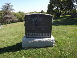
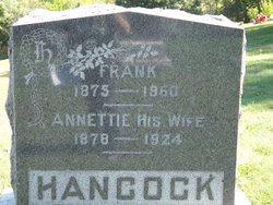
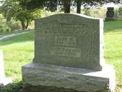
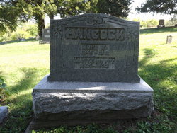
James Franklin “Frank” Hancock
| Birth | : | 25 Jun 1875 Davis County, Iowa, USA |
| Death | : | 11 May 1960 Ottumwa, Wapello County, Iowa, USA |
| Burial | : | Wolvercote Cemetery, Oxford, City of Oxford, England |
| Coordinate | : | 51.7913666, -1.2721500 |
| Description | : | James Franklin (Frank) Hancock, 85, died Wed. at 3:45 p.m. at Rest Haven Nursing Home in Ottumwa after a short illness. He was a farmer near Floris most of his life, going to the nursing home a year ago. The son of Wesley and Mary Hancock, he was born in Davis Co. June 25, 1875. He was married to Annette Rupe, who died in 1923. He was married in 1936 to Ethel Schaub, who survives. Besides his wife he leaves two sons, Gerald of Los Angeles and Russell of Davenport; two daughters, Mrs. Martylla Rocky of Modesta,... Read More |
frequently asked questions (FAQ):
-
Where is James Franklin “Frank” Hancock's memorial?
James Franklin “Frank” Hancock's memorial is located at: Wolvercote Cemetery, Oxford, City of Oxford, England.
-
When did James Franklin “Frank” Hancock death?
James Franklin “Frank” Hancock death on 11 May 1960 in Ottumwa, Wapello County, Iowa, USA
-
Where are the coordinates of the James Franklin “Frank” Hancock's memorial?
Latitude: 51.7913666
Longitude: -1.2721500
Family Members:
Parent
Spouse

Siblings

Children
Flowers:


Nearby Cemetories:
1. Wolvercote Cemetery
Oxford, City of Oxford, England
Coordinate: 51.7913666, -1.2721500
2. St. Peter Churchyard
Wolvercote, City of Oxford, England
Coordinate: 51.7848300, -1.2811100
3. St Michael and All Angels Summertown
Oxford, City of Oxford, England
Coordinate: 51.7796280, -1.2643940
4. Godstow Abbey Ruins
Oxford, City of Oxford, England
Coordinate: 51.7784060, -1.2998170
5. St. Bartholomew's Churchyard
Yarnton, Cherwell District, England
Coordinate: 51.8016610, -1.3087620
6. Yarnton Cemetery
Yarnton, Cherwell District, England
Coordinate: 51.8004080, -1.3103260
7. St. Nicholas Churchyard
Old Marston, City of Oxford, England
Coordinate: 51.7761340, -1.2373130
8. Saint Margaret of Antioch
City of Oxford, England
Coordinate: 51.7690340, -1.2975900
9. Elsfield Road Cemetery
Old Marston, City of Oxford, England
Coordinate: 51.7752940, -1.2332640
10. St. Sepulchres Cemetery
Oxford, City of Oxford, England
Coordinate: 51.7611110, -1.2694440
11. Wytham Churchyard
Wytham, Vale of White Horse District, England
Coordinate: 51.7736230, -1.3131610
12. Woodeaton Holy Rood Churchyard
Woodeaton, South Oxfordshire District, England
Coordinate: 51.8031620, -1.2257910
13. St Paul's Oxford Cemetery
Oxford, City of Oxford, England
Coordinate: 51.7594590, -1.2648470
14. St Giles Churchyard
Oxford, City of Oxford, England
Coordinate: 51.7591660, -1.2605170
15. Saint Barnabas Church
Oxford, City of Oxford, England
Coordinate: 51.7579620, -1.2697600
16. St Thomas of Canterbury Churchyard
Elsfield, South Oxfordshire District, England
Coordinate: 51.7858680, -1.2178310
17. Mansfield College Chapel
Oxford, City of Oxford, England
Coordinate: 51.7576410, -1.2523340
18. Blackfriars
Oxford, City of Oxford, England
Coordinate: 51.7561210, -1.2602060
19. St Johns College
Oxford, City of Oxford, England
Coordinate: 51.7560820, -1.2589910
20. Wadham College Chapel
Oxford, City of Oxford, England
Coordinate: 51.7560700, -1.2540350
21. Rewley Abbey
Oxford, City of Oxford, England
Coordinate: 51.7543810, -1.2675170
22. Martyrs' Memorial
Oxford, City of Oxford, England
Coordinate: 51.7550900, -1.2590100
23. Kidlington Burial Ground
Kidlington, Cherwell District, England
Coordinate: 51.8266010, -1.2916660
24. Trinity College Chapel
Oxford, City of Oxford, England
Coordinate: 51.7552360, -1.2569620