
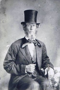
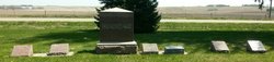
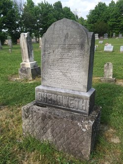
James “Lewis” Chenoweth
| Birth | : | 5 Feb 1812 Warren County, Ohio, USA |
| Death | : | 13 Jun 1868 Allen County, Ohio, USA |
| Burial | : | Burnley Cemetery, Burnley, Burnley Borough, England |
| Coordinate | : | 53.7821730, -2.2795070 |
| Description | : | excerpt from chenowethsite.com: James was born February 05, 1812 in Warren Co., OH. The Harris book misplaced James as the probable son of William, the son of William S. and Catherine Rinker. This is incorrect; that William did not marry until 1825. It is now believed that James is, rather, the son of William S. and his second wife, Ann McCool. This belief includes the view that James is the son Lewis mentioned in William's will of 1839. This Lewis is never found but James is listed in 3 consecutive Censuses of Allen Co. from 1840. It could be... Read More |
frequently asked questions (FAQ):
-
Where is James “Lewis” Chenoweth's memorial?
James “Lewis” Chenoweth's memorial is located at: Burnley Cemetery, Burnley, Burnley Borough, England.
-
When did James “Lewis” Chenoweth death?
James “Lewis” Chenoweth death on 13 Jun 1868 in Allen County, Ohio, USA
-
Where are the coordinates of the James “Lewis” Chenoweth's memorial?
Latitude: 53.7821730
Longitude: -2.2795070
Family Members:
Parent

Spouse
Siblings
Children

Flowers:


Nearby Cemetories:
1. Burnley Cemetery
Burnley, Burnley Borough, England
Coordinate: 53.7821730, -2.2795070
2. Burnley Crematorium
Burnley, Burnley Borough, England
Coordinate: 53.7821730, -2.2795070
3. Holy Trinity Churchyard
Burnley, Burnley Borough, England
Coordinate: 53.7898290, -2.2574200
4. All Saints Churchyard
Habergham Eaves, Burnley Borough, England
Coordinate: 53.7971060, -2.2913770
5. St. James' Churchyard
Burnley, Burnley Borough, England
Coordinate: 53.7905590, -2.2458280
6. St Margaret Churchyard
Hapton, Burnley Borough, England
Coordinate: 53.7802400, -2.3169230
7. St. John's Cemetery
Padiham, Burnley Borough, England
Coordinate: 53.7948720, -2.3145290
8. St. Peter's Churchyard
Burnley, Burnley Borough, England
Coordinate: 53.7924450, -2.2394890
9. Ebenezer Baptist Chapel Chapelyard
Burnley, Burnley Borough, England
Coordinate: 53.7975120, -2.2397260
10. St. Leonard's Churchyard
Padiham, Burnley Borough, England
Coordinate: 53.8022600, -2.3164300
11. Wesleyan Methodist Chapel Chapelyard
Padiham, Burnley Borough, England
Coordinate: 53.8018980, -2.3181730
12. St Leonard Churchyard Extension
Padiham, Burnley Borough, England
Coordinate: 53.7991800, -2.3222000
13. Providence Free United Methodist Graveyard
Crawshawbooth, Rossendale Borough, England
Coordinate: 53.7442070, -2.2825700
14. St James Church
Altham, Hyndburn Borough, England
Coordinate: 53.7928940, -2.3465250
15. St John Churchyard
Higham, Pendle Borough, England
Coordinate: 53.8251420, -2.2898120
16. Accrington Cemetery and Crematorium
Accrington, Hyndburn Borough, England
Coordinate: 53.7623787, -2.3508649
17. Rehoboth Chapel
Goodshaw, Rossendale Borough, England
Coordinate: 53.7355870, -2.2914730
18. St. Anne Churchyard
Fence, Pendle Borough, England
Coordinate: 53.8304372, -2.2679552
19. Goodshaw Particular Baptist Chapel Graveyard
Goodshaw, Rossendale Borough, England
Coordinate: 53.7328210, -2.2815530
20. St. Mary and All Saints Churchyard
Goodshaw, Rossendale Borough, England
Coordinate: 53.7315270, -2.2828940
21. Wheatley Lane Methodist Churchyard
Fence, Pendle Borough, England
Coordinate: 53.8341457, -2.2596202
22. St. James' Churchyard
Briercliffe, Burnley Borough, England
Coordinate: 53.8107700, -2.2031800
23. St. John's Churchyard
Read, Ribble Valley Borough, England
Coordinate: 53.8088800, -2.3585600
24. St Marys Burial Ground
Clayton-le-Moors, Hyndburn Borough, England
Coordinate: 53.7792778, -2.3705871