
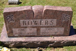
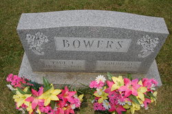
James M Bowers
| Birth | : | Jan 1878 Oakland, Garrett County, Maryland, USA |
| Death | : | 4 Jul 1939 Deer Park, Garrett County, Maryland, USA |
| Burial | : | Harwood Park Crematorium, Stevenage, Stevenage Borough, England |
| Coordinate | : | 51.8717680, -0.1698410 |
| Description | : | OBITUARY – JAMES M. BOWERS Oakland, MD., July 7. Funeral Services were held for James M. Bowers, 60, from White Church, with internment in the church cemetery. Rev. G. W. Burkhart, Elk Garden, W. VA., officiated assisted by Rev. Harold Gamblin, Mt. Lake Park. Mr. Bowers died of a heart attack while at work in his cornfield on Tuesday morning, July 4. He had undergone an appendectomy about a year ago and had not been in the best of health since that time. His son, Paul Boers, was working with him but had gone to the house for a few minutes.... Read More |
frequently asked questions (FAQ):
-
Where is James M Bowers's memorial?
James M Bowers's memorial is located at: Harwood Park Crematorium, Stevenage, Stevenage Borough, England.
-
When did James M Bowers death?
James M Bowers death on 4 Jul 1939 in Deer Park, Garrett County, Maryland, USA
-
Where are the coordinates of the James M Bowers's memorial?
Latitude: 51.8717680
Longitude: -0.1698410
Family Members:
Parent

Spouse

Siblings
Children
Flowers:


Nearby Cemetories:
1. St Martin
Knebworth, North Hertfordshire District, England
Coordinate: 51.8654900, -0.1820500
2. All Saints Churchyard
Datchworth, East Hertfordshire District, England
Coordinate: 51.8575577, -0.1609916
3. Knebworth Cemetery
Knebworth, North Hertfordshire District, England
Coordinate: 51.8595280, -0.1867730
4. St. Mary's Churchyard
Aston, East Hertfordshire District, England
Coordinate: 51.8875600, -0.1536200
5. St. Mary's Churchyard
Knebworth, North Hertfordshire District, England
Coordinate: 51.8723580, -0.2160890
6. St Peter Churchyard
Benington, East Hertfordshire District, England
Coordinate: 51.8956030, -0.1167310
7. Ss Mary and Andrew Churchyard
Watton-at-Stone, East Hertfordshire District, England
Coordinate: 51.8533290, -0.1102500
8. High Street Methodist Church
Stevenage, Stevenage Borough, England
Coordinate: 51.9080740, -0.2061550
9. Almond Lane Cemetery
Stevenage, Stevenage Borough, England
Coordinate: 51.9161780, -0.1954710
10. St. Mary's Churchyard
Welwyn, Welwyn Hatfield District, England
Coordinate: 51.8311660, -0.2151400
11. Welwyn Cemetery
Welwyn, Welwyn Hatfield District, England
Coordinate: 51.8331340, -0.2199520
12. St Nicholas Churchyard
Stevenage, Stevenage Borough, England
Coordinate: 51.9201590, -0.1974750
13. Weston Road Cemetery
Stevenage, Stevenage Borough, England
Coordinate: 51.9217860, -0.1935160
14. St Andrew Church
Bramfield, East Hertfordshire District, England
Coordinate: 51.8241000, -0.1266000
15. St John the Evangelist Churchyard
Digswell, Welwyn Hatfield District, England
Coordinate: 51.8186190, -0.2051940
16. St Mary the Virgin Churchyard
Stapleford, East Hertfordshire District, England
Coordinate: 51.8349710, -0.0973140
17. St. Mary the Virgin Churchyard
Walkern, East Hertfordshire District, England
Coordinate: 51.9226300, -0.1211300
18. All Saints Churchyard
St Pauls Walden, North Hertfordshire District, England
Coordinate: 51.8865400, -0.2689200
19. St Peter Churchyard
Ayot St Peter, Welwyn Hatfield District, England
Coordinate: 51.8201700, -0.2331800
20. Minsden Chapel
Hitchin, North Hertfordshire District, England
Coordinate: 51.9069200, -0.2595700
21. All Saints Churchyard
Little Munden, East Hertfordshire District, England
Coordinate: 51.8795770, -0.0625920
22. Ayot St Lawrence Old Churchyard
Ayot St Lawrence, Welwyn Hatfield District, England
Coordinate: 51.8377038, -0.2678795
23. St Lawrence Churchyard
Ardeley, East Hertfordshire District, England
Coordinate: 51.9274000, -0.0989000
24. St Lawrence Churchyard
Ayot St Lawrence, Welwyn Hatfield District, England
Coordinate: 51.8379490, -0.2717340