
| Birth | : | 15 Dec 1932 Cherokee Falls, Cherokee County, South Carolina, USA |
| Death | : | 5 Jan 1994 Gaffney, Cherokee County, South Carolina, USA |
| Burial | : | St John’s Church Graveyard, Ellel, City of Lancaster, England |
| Coordinate | : | 53.9990010, -2.7846660 |
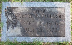
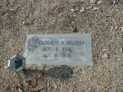
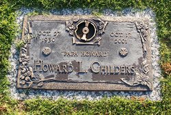
| Description | : | Cherokee Falls - James Nelson Childers, 61, of 408 Upper Deal Street, died Jan. 5, 1994, in Upstate Carolina Medical Center. A native of Cherokee Falls, he was the husband of Carolyn Seals Childers and son of the late Robert Lee and Catherine Maynor Childers. He was a member of Cherokee Falls Baptist Church and was a retired textile worker. Also surviving are three daughters, Reita Martin of Cherokee Falls and Kathy and Wendy Childers of the home; three sons, Andy Childers of Gaffney, Chris Childers of Blacksburg and Nelson Childers of the home; four brothers, R.L., Howard and Terry... Read More |
frequently asked questions (FAQ):
-
Where is James Nelson Childers's memorial?
James Nelson Childers's memorial is located at: St John’s Church Graveyard, Ellel, City of Lancaster, England.
-
When did James Nelson Childers death?
James Nelson Childers death on 5 Jan 1994 in Gaffney, Cherokee County, South Carolina, USA
-
Where are the coordinates of the James Nelson Childers's memorial?
Latitude: 53.9990010
Longitude: -2.7846660
Family Members:
Parent
Spouse

Siblings


Nearby Cemetories:
1. St. Mary's Chapel Ellel Grange
Ellel, City of Lancaster, England
Coordinate: 53.9756944, -2.7918522
2. St Thomas with Elizabeth Churchyard
Thurnham, City of Lancaster, England
Coordinate: 53.9819990, -2.8159520
3. Scotforth Cemetery
Scotforth, City of Lancaster, England
Coordinate: 54.0282250, -2.8007170
4. Christ Church of Glasson Churchyard
Glasson, City of Lancaster, England
Coordinate: 53.9966870, -2.8421460
5. St Mark Churchyard
Dolphinholme, City of Lancaster, England
Coordinate: 53.9738730, -2.7378420
6. Quernmore Methodist Churchyard
Quernmore, City of Lancaster, England
Coordinate: 54.0259440, -2.7361400
7. St. Helen's Churchyard
Overton, City of Lancaster, England
Coordinate: 54.0111620, -2.8552950
8. Saint Michael's and All Angels Church Cemetery
Cockerham, City of Lancaster, England
Coordinate: 53.9602092, -2.8204877
9. Forton United Reform Church Cemetery
Forton, Wyre Borough, England
Coordinate: 53.9547940, -2.7813920
10. St Peter's Churchyard
Quernmore, City of Lancaster, England
Coordinate: 54.0367200, -2.7375400
11. St Paul's Churchyard
Forton, Wyre Borough, England
Coordinate: 53.9543760, -2.7605890
12. Cathedral Cemetery of Lancaster
Lancaster, City of Lancaster, England
Coordinate: 54.0471170, -2.7942920
13. Mount Street Congregational Chapel
Lancaster, City of Lancaster, England
Coordinate: 54.0468260, -2.8027430
14. St. Nicholas Street Chapel Churchyard
Lancaster, City of Lancaster, England
Coordinate: 54.0486900, -2.7987900
15. Friends Meeting House Burial Ground
Lancaster, City of Lancaster, England
Coordinate: 54.0482500, -2.8058025
16. Lancaster Cemetery
Lancaster, City of Lancaster, England
Coordinate: 54.0504210, -2.7768760
17. Lancaster Castle Cemetery
Lancaster, City of Lancaster, England
Coordinate: 54.0494330, -2.8047890
18. St. John the Evangelist Churchyard
Lancaster, City of Lancaster, England
Coordinate: 54.0504000, -2.7990000
19. Lancaster Priory
Lancaster, City of Lancaster, England
Coordinate: 54.0507360, -2.8057850
20. Quaker Burial Ground
Abbeystead, City of Lancaster, England
Coordinate: 53.9910820, -2.6912370
21. Saint Luke's Parish Churchyard
Skerton, City of Lancaster, England
Coordinate: 54.0564700, -2.7982600
22. Christ Church Churchyard
Over Wyresdale, City of Lancaster, England
Coordinate: 53.9839250, -2.6861150
23. Skerton Cemetery
Lancaster, City of Lancaster, England
Coordinate: 54.0651430, -2.7951140
24. Lancaster and Morecambe Crematorium
Lancaster, City of Lancaster, England
Coordinate: 54.0650890, -2.8198420