
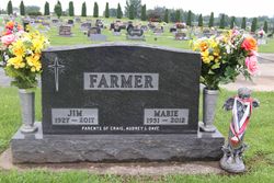
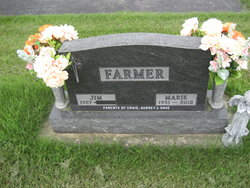
James Ormus “Jim” Farmer
| Birth | : | 18 Jun 1927 Clermont, Fayette County, Iowa, USA |
| Death | : | 23 Dec 2017 Gunder, Clayton County, Iowa, USA |
| Burial | : | St James Cemetery, Dover, Dover District, England |
| Coordinate | : | 51.1361389, 1.3146530 |
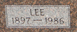
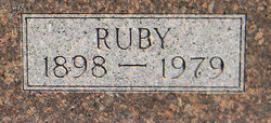
| Description | : | James “Jim” Ormus Farmer, 90, of Gunder, Iowa died Saturday, December 23, 2017 at his home. James Ormus was born June 18, 1927 to Lee and Ruby (Trudo) Farmer in Clermont, Iowa. He attended Grand Meadow Country School near Clermont through the ninth grade and attended one year of high school in Postville. Jim was united in marriage with Marie Bollman on June 16, 1952 at Monona Methodist Church, Monona, Iowa. To this union three children were born. He was a hard working dairy farmer his entire life and would do anything for anybody. After retiring from dairy farming,... Read More |
frequently asked questions (FAQ):
-
Where is James Ormus “Jim” Farmer's memorial?
James Ormus “Jim” Farmer's memorial is located at: St James Cemetery, Dover, Dover District, England.
-
When did James Ormus “Jim” Farmer death?
James Ormus “Jim” Farmer death on 23 Dec 2017 in Gunder, Clayton County, Iowa, USA
-
Where are the coordinates of the James Ormus “Jim” Farmer's memorial?
Latitude: 51.1361389
Longitude: 1.3146530
Family Members:
Parent
Spouse
Flowers:


Nearby Cemetories:
1. St James Cemetery
Dover, Dover District, England
Coordinate: 51.1361389, 1.3146530
2. Dover Jewish Cemetery
Dover, Dover District, England
Coordinate: 51.1366310, 1.3106850
3. Charlton Cemetery
Dover, Dover District, England
Coordinate: 51.1366920, 1.3101200
4. St Marys New Cemetery
Dover, Dover District, England
Coordinate: 51.1345300, 1.3073700
5. St Peter and St Paul Churchyard
Dover, Dover District, England
Coordinate: 51.1331673, 1.3062360
6. Dover War Memorial
Dover, Dover District, England
Coordinate: 51.1277847, 1.3091190
7. St Mary in Castro Churchyard
Dover, Dover District, England
Coordinate: 51.1283490, 1.3232430
8. St. James Old Churchyard
Dover, Dover District, England
Coordinate: 51.1261340, 1.3177210
9. St Mary the Virgin Churchyard
Dover, Dover District, England
Coordinate: 51.1259842, 1.3127910
10. Dover Priory (Defunct)
Dover, Dover District, England
Coordinate: 51.1258370, 1.3053770
11. Cowgate Cemetery
Dover, Dover District, England
Coordinate: 51.1237970, 1.3101560
12. St Andrew Churchyard
Buckland, Dover District, England
Coordinate: 51.1373749, 1.2937800
13. St Peter and St Paul Churchyard
River, Dover District, England
Coordinate: 51.1447480, 1.2733710
14. St Peter Churchyard
Whitfield, Dover District, England
Coordinate: 51.1655000, 1.3037000
15. St Augustine's Church
East Langdon, Dover District, England
Coordinate: 51.1654990, 1.3357270
16. Saint Peters Church
Westcliffe, Dover District, England
Coordinate: 51.1542430, 1.3573340
17. St. Peter and St. Paul's Churchyard
Temple Ewell, Dover District, England
Coordinate: 51.1515565, 1.2675213
18. St. Margaret of Antioch Churchyard
St Margarets at Cliffe, Dover District, England
Coordinate: 51.1534950, 1.3714350
19. St Laurence the Martyr Churchyard
Church Hougham, Dover District, England
Coordinate: 51.1137180, 1.2536650
20. All Saints Churchyard
Waldershare, Dover District, England
Coordinate: 51.1875170, 1.2857870
21. Saint Mary the Virgin Churchyard
Lydden, Dover District, England
Coordinate: 51.1658200, 1.2373050
22. St Anthony Churchyard
Alkham, Dover District, England
Coordinate: 51.1360930, 1.2226440
23. Saint Pancras Churchyard
Coldred, Dover District, England
Coordinate: 51.1822600, 1.2529260
24. St. Mary's Churchyard
Capel-le-Ferne, Dover District, England
Coordinate: 51.1149650, 1.2235540