Jane West Turner
| Birth | : | 1797 Madison County, Kentucky, USA |
| Death | : | 20 Apr 1867 Ray County, Missouri, USA |
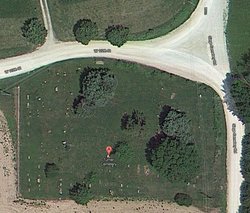
| Burial | : | Siegel Cemetery, Excelsior Springs, Ray County, USA |
| Coordinate | : | 39.2943993, -94.1977997 |
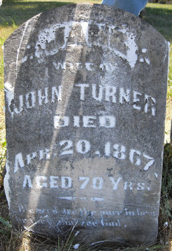
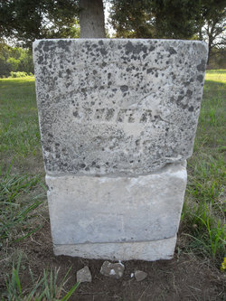
| Inscription | : | Jane Wife of John Turner Died Apr 20, 1867 Aged 70 Yrs Blessed are the pure in heart for they shall see God |
| Description | : | Jane West married John Turner in Madison County, Kentucky in July 1814 following John's return from service in the War of 1812. John & Jane moved to the Missouri Territory in 1816, to what would become Ray County, Missouri. |
frequently asked questions (FAQ):
-
Where is Jane West Turner's memorial?
Jane West Turner's memorial is located at: Siegel Cemetery, Excelsior Springs, Ray County, USA.
-
When did Jane West Turner death?
Jane West Turner death on 20 Apr 1867 in Ray County, Missouri, USA
-
Where are the coordinates of the Jane West Turner's memorial?
Latitude: 39.2943993
Longitude: -94.1977997
Family Members:
Spouse
Children
Flowers:
Left by Anonymous on 08 Jun 2012
Left by Anonymous on 18 Sep 2012
Never Forgotten
Left by Anonymous on 23 May 2014
Left by Anonymous on 14 Jul 2014
Jane West is daughter of Littleton West. My ancestors (O'Dells and Loyds) are also buried here in Siegel.
Left by Anonymous on 13 Aug 2018
Left by Anonymous on 14 Sep 2019
In memory of my 4th Great Grandmother Jane West Turner
Left by Anonymous on 20 Apr 2021
Nearby Cemetories:
1. Enon Cemetery
Excelsior Springs, Clay County, USA
Coordinate: 39.2958984, -94.2221985
2. Bogart Family Cemetery
Ray County, USA
Coordinate: 39.2644400, -94.1777800
3. Old New Garden Primitive Baptist Cemetery
Wood Heights, Ray County, USA
Coordinate: 39.3227005, -94.1669006
4. North New Garden Primitive Baptist Church Cemetery
Wood Heights, Ray County, USA
Coordinate: 39.3271027, -94.1648026
5. Elitzer Cemetery
Miltondale, Clay County, USA
Coordinate: 39.2595640, -94.2289210
6. Union Baptist Cemetery
Orrick, Ray County, USA
Coordinate: 39.2507133, -94.1969070
7. Cox Cemetery
Wood Heights, Ray County, USA
Coordinate: 39.3368988, -94.1819000
8. Pisgah Cemetery
Wood Heights, Ray County, USA
Coordinate: 39.3376846, -94.1775055
9. O'Dell Cemetery
Excelsior Springs, Ray County, USA
Coordinate: 39.2995987, -94.1346970
10. Moore Cemetery
Excelsior Springs, Clay County, USA
Coordinate: 39.2696991, -94.2530975
11. Scott Cemetery
Clay County, USA
Coordinate: 39.2708015, -94.2538986
12. Old Allen Cemetery
Ray County, USA
Coordinate: 39.2433281, -94.1977005
13. Rowland Cemetery
Ray County, USA
Coordinate: 39.2694016, -94.1389008
14. Elmwood Cemetery
Excelsior Springs, Clay County, USA
Coordinate: 39.3353004, -94.2485962
15. Riffe Cemetery
Orrick, Ray County, USA
Coordinate: 39.2514000, -94.1492004
16. Rock Falls Church Cemetery
Elkhorn, Ray County, USA
Coordinate: 39.2893500, -94.1221800
17. Windy Hill Cemetery
Wood Heights, Ray County, USA
Coordinate: 39.3407364, -94.1462250
18. McKee-Moore Cemetery
Clay County, USA
Coordinate: 39.3315630, -94.2608620
19. Masonic Cemetery
Excelsior Springs, Clay County, USA
Coordinate: 39.3432655, -94.2482910
20. Crown Hill Cemetery
Excelsior Springs, Clay County, USA
Coordinate: 39.3446999, -94.2474976
21. Welton Cemetery
Clay County, USA
Coordinate: 39.3292800, -94.2663300
22. Hamers Farm Cemetery
Ray County, USA
Coordinate: 39.3560400, -94.1762900
23. Hillcrest Cemetery
Excelsior Springs, Clay County, USA
Coordinate: 39.3358002, -94.2619019
24. John Cleavenger Cemetery
Crystal Lakes, Ray County, USA
Coordinate: 39.3551407, -94.1542053

