
| Birth | : | 31 Jan 1939 Panama, Shelby County, Iowa, USA |
| Death | : | 30 Jun 2012 Council Bluffs, Pottawattamie County, Iowa, USA |
| Burial | : | Garner Cemetery, Council Bluffs, Pottawattamie County, USA |
| Coordinate | : | 41.2956161, -95.8001709 |
| Plot | : | Blk 5, Lot 22, Space 2 |
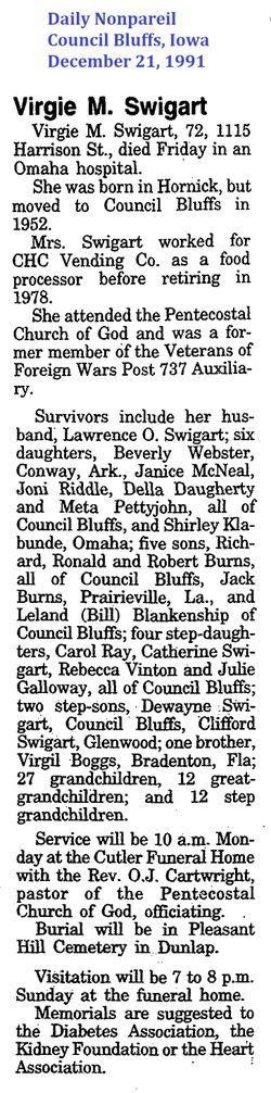
| Description | : | Janice Louise McNeal, age 73, passed away Saturday, June 30, 2012, at her home. Janice was born January 31, 1939, in Panama, Iowa, to Walter and Virgie Boggs Burns. Janice worked as a receptionist at Baum Iron for over 22 years and Auto Mart 150 for over 5 years, and was very fond of her cats. She was preceded in death by her parents; and brothers, Ron and Dick Burns. Survivors include her husband, Don, whom she married on March 25, 1983; sons, Joe Gascoigne and wife, Marie; Dennis Gascoigne and wife, Lori; step-children, Sally Hall and husband, Bill, Judy Webster and husband,... Read More |
frequently asked questions (FAQ):
-
Where is Janice Louise Burns McNeal's memorial?
Janice Louise Burns McNeal's memorial is located at: Garner Cemetery, Council Bluffs, Pottawattamie County, USA.
-
When did Janice Louise Burns McNeal death?
Janice Louise Burns McNeal death on 30 Jun 2012 in Council Bluffs, Pottawattamie County, Iowa, USA
-
Where are the coordinates of the Janice Louise Burns McNeal's memorial?
Latitude: 41.2956161
Longitude: -95.8001709
Family Members:
Parent
Spouse

Siblings


Children
Flowers:


Nearby Cemetories:
1. Garner Cemetery
Council Bluffs, Pottawattamie County, USA
Coordinate: 41.2956161, -95.8001709
2. Green Valley Cemetery
Council Bluffs, Pottawattamie County, USA
Coordinate: 41.2743988, -95.8225021
3. Saint Joseph Cemetery
Council Bluffs, Pottawattamie County, USA
Coordinate: 41.2722015, -95.8208008
4. Cedar Lawn Cemetery
Council Bluffs, Pottawattamie County, USA
Coordinate: 41.2694016, -95.8182983
5. Walnut Hill Cemetery
Council Bluffs, Pottawattamie County, USA
Coordinate: 41.2719002, -95.8255997
6. Bikhor Cholim Cemetery
Council Bluffs, Pottawattamie County, USA
Coordinate: 41.2703670, -95.8229350
7. Oak Hill Cemetery
Council Bluffs, Pottawattamie County, USA
Coordinate: 41.2700900, -95.8226400
8. Ridgewood Cemetery
Council Bluffs, Pottawattamie County, USA
Coordinate: 41.2694016, -95.8272018
9. Memorial Park Cemetery
Council Bluffs, Pottawattamie County, USA
Coordinate: 41.2644005, -95.8261032
10. Gregg Cemetery
Weston, Pottawattamie County, USA
Coordinate: 41.3330000, -95.7931000
11. Evans Cemetery
Crescent, Pottawattamie County, USA
Coordinate: 41.3255997, -95.8368988
12. Clark Cemetery
Pottawattamie County, USA
Coordinate: 41.2551610, -95.8223390
13. Fairview Cemetery
Council Bluffs, Pottawattamie County, USA
Coordinate: 41.2703018, -95.8480988
14. Stoker-Graybill Cemetery
Council Bluffs, Pottawattamie County, USA
Coordinate: 41.2532620, -95.7751770
15. Hazel Dell Cemetery
Council Bluffs, Pottawattamie County, USA
Coordinate: 41.3489723, -95.7939911
16. Saint Columbanus Cemetery
Weston, Pottawattamie County, USA
Coordinate: 41.3429440, -95.7435260
17. Maple Grove Cemetery
Council Bluffs, Pottawattamie County, USA
Coordinate: 41.2265560, -95.8187100
18. Crescent Cemetery
Crescent, Pottawattamie County, USA
Coordinate: 41.3664894, -95.8566208
19. Lewis Township Cemetery
Council Bluffs, Pottawattamie County, USA
Coordinate: 41.2117004, -95.7938995
20. Downsville Cemetery
Pottawattamie County, USA
Coordinate: 41.3502998, -95.7039032
21. Council Point Cemetery
Council Bluffs, Pottawattamie County, USA
Coordinate: 41.2110830, -95.8788610
22. Pottawattamie County Home Cemetery
McClelland, Pottawattamie County, USA
Coordinate: 41.3269400, -95.6691738
23. Trinity Cathedral Columbarium
Omaha, Douglas County, USA
Coordinate: 41.2603900, -95.9393660
24. Hardin Township Cemetery
McClelland, Pottawattamie County, USA
Coordinate: 41.2949982, -95.6513977