| Birth | : | 14 Sep 1884 Hiawatha, Brown County, Kansas, USA |
| Death | : | 11 Feb 1961 Kansas City, Jackson County, Missouri, USA |
| Burial | : | Hiawatha Cemetery, Hiawatha, Brown County, USA |
| Coordinate | : | 39.8601799, -95.5265198 |
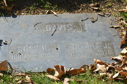
| Description | : | Jay Stanley Davis married Ruth Evelyn Kay. Based on census records, they were married in the fall of 1919 and divorced within 10 years. June 1, 1900 census. DAVIS family. Hiawatha, Brown Co., KS. Jasper N., head, b.May 1850, 50, marr.28yrs, b.Wisc., parents b.England, cigar maker. Emma L., wife, b.Sept 1856, 43, marr.28yrs, mother of 11(10living), b.Wisc., parents b.OH. Ross H., son, b.May 1880, 20, single, b.KS. Stella L., dau, b.Oct 1882, 17, single, b.KS. Stanley J., son, b.Sept 1884, 15, b.KS. Benjamin?, son, b.Jun or Jan 1887, 13, b.KS. Gladys, dau, b.Jan or Jun 1891, 9, b.KS. Pauline E., dau, b.Apr 1895, 5, b.KS. Eunice M., dau, b.Aug 1896, 3,... Read More |
frequently asked questions (FAQ):
-
Where is Jay Stanley Davis's memorial?
Jay Stanley Davis's memorial is located at: Hiawatha Cemetery, Hiawatha, Brown County, USA.
-
When did Jay Stanley Davis death?
Jay Stanley Davis death on 11 Feb 1961 in Kansas City, Jackson County, Missouri, USA
-
Where are the coordinates of the Jay Stanley Davis's memorial?
Latitude: 39.8601799
Longitude: -95.5265198
Family Members:
Parent
Siblings
Flowers:
Nearby Cemetories:
1. Hiawatha Cemetery
Hiawatha, Brown County, USA
Coordinate: 39.8601799, -95.5265198
2. Mount Hope Cemetery
Hiawatha, Brown County, USA
Coordinate: 39.8497009, -95.5156021
3. Bemis Cemetery
Hiawatha, Brown County, USA
Coordinate: 39.8194900, -95.5668300
4. Niles Cemetery
Hiawatha, Brown County, USA
Coordinate: 39.8730900, -95.6126300
5. Oakland Cemetery
Padonia, Brown County, USA
Coordinate: 39.9273900, -95.5610900
6. Claytonville Cemetery
Horton, Brown County, USA
Coordinate: 39.7766991, -95.5046997
7. Ununda Cemetery
Robinson, Brown County, USA
Coordinate: 39.8582993, -95.4143982
8. Shelton Cemetery
Hamlin, Brown County, USA
Coordinate: 39.8852997, -95.6393967
9. Hart Cemetery
Reserve, Brown County, USA
Coordinate: 39.9519005, -95.5366974
10. Carson Cemetery
Hamlin, Brown County, USA
Coordinate: 39.8810200, -95.6483100
11. Hamlin Cemetery
Hamlin, Brown County, USA
Coordinate: 39.9206009, -95.6292877
12. Rose Hill Cemetery
Robinson, Brown County, USA
Coordinate: 39.8097000, -95.4139023
13. Pleasant Hill Cemetery
Irving Township, Brown County, USA
Coordinate: 39.9435997, -95.4328232
14. Kenyon Cemetery
Robinson, Brown County, USA
Coordinate: 39.9122000, -95.3964600
15. Pleasant Hill Cemetery
Fairview, Brown County, USA
Coordinate: 39.8411800, -95.6716400
16. Saint Paul Lutheran Cemetery
Fairview, Brown County, USA
Coordinate: 39.8559700, -95.6779700
17. Cornelison Cemetery
Reserve, Brown County, USA
Coordinate: 39.9754105, -95.5485687
18. Madison Cemetery
Robinson, Brown County, USA
Coordinate: 39.7717700, -95.4201700
19. Powhattan Cemetery
Powhattan, Brown County, USA
Coordinate: 39.7681007, -95.6288986
20. Immanuel Lutheran Cemetery
Fairview, Brown County, USA
Coordinate: 39.8559700, -95.6858500
21. Laus Creek Cemetery
Reserve, Brown County, USA
Coordinate: 39.9754105, -95.4699936
22. Pleasant Hill Cemetery
Hamlin, Brown County, USA
Coordinate: 39.9430428, -95.6484299
23. Sun Springs Cemetery
Morrill, Brown County, USA
Coordinate: 39.8993988, -95.6836014
24. Old Fairview Cemetery
Fairview, Brown County, USA
Coordinate: 39.8550491, -95.6948700


