

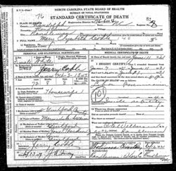
Jesse Franklin Coble
| Birth | : | 30 Jul 1869 Guilford County, North Carolina, USA |
| Death | : | 23 Jul 1947 Randleman, Randolph County, North Carolina, USA |
| Burial | : | SS Peter & Paul Churchyard, Shelford, Rushcliffe Borough, England |
| Coordinate | : | 52.9745600, -1.0161200 |
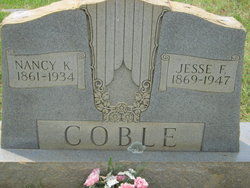
| Description | : | Father: Jeremiah Sr. "Jerry" COBLE b: 1843 in Guilford Co., NC Mother: Marybell Elizabeth "Mary" SWAIM b: 3 Oct 1847 in Randolph Co., NC Marriage 1 Minnie HAYES Marriage 2 Nancy K. C. HAYES b: 1861 in Randolph Co., NC |
frequently asked questions (FAQ):
-
Where is Jesse Franklin Coble's memorial?
Jesse Franklin Coble's memorial is located at: SS Peter & Paul Churchyard, Shelford, Rushcliffe Borough, England.
-
When did Jesse Franklin Coble death?
Jesse Franklin Coble death on 23 Jul 1947 in Randleman, Randolph County, North Carolina, USA
-
Where are the coordinates of the Jesse Franklin Coble's memorial?
Latitude: 52.9745600
Longitude: -1.0161200
Family Members:
Parent
Spouse
Siblings

Children

Flowers:


Nearby Cemetories:
1. SS Peter & Paul Churchyard
Shelford, Rushcliffe Borough, England
Coordinate: 52.9745600, -1.0161200
2. Shelford Priory
Shelford, Rushcliffe Borough, England
Coordinate: 52.9830600, -0.9994100
3. St Luke's Churchyard
Stoke Bardolph, Gedling Borough, England
Coordinate: 52.9680500, -1.0389300
4. St. Luke's Churchyard
Stoke Bardolph, Gedling Borough, England
Coordinate: 52.9659896, -1.0404380
5. Burton Joyce Cemetery
Burton Joyce, Gedling Borough, England
Coordinate: 52.9863100, -1.0370710
6. St. Helen's Churchyard
Burton Joyce, Gedling Borough, England
Coordinate: 52.9866700, -1.0365400
7. St John the Baptist Gunthorpe
Gunthorpe, Newark and Sherwood District, England
Coordinate: 52.9925600, -0.9877400
8. Saint Peter Churchyard
East Bridgford, Rushcliffe Borough, England
Coordinate: 52.9809170, -0.9726560
9. St Mary Churchyard
Radcliffe-on-Trent, Rushcliffe Borough, England
Coordinate: 52.9464660, -1.0419420
10. Radcliffe-on-Trent Cemetery
Radcliffe-on-Trent, Rushcliffe Borough, England
Coordinate: 52.9459200, -1.0409700
11. All Hallows Churchyard
Gedling, Gedling Borough, England
Coordinate: 52.9769400, -1.0805130
12. Lowdham Saint Mary Churchyard Extension
Lowdham, Newark and Sherwood District, England
Coordinate: 53.0143500, -1.0125800
13. St Mary the Virgin Churchyard
Lowdham, Newark and Sherwood District, England
Coordinate: 53.0146670, -1.0135510
14. Gedling Cemetery
Gedling, Gedling Borough, England
Coordinate: 52.9806930, -1.0870670
15. Carlton Cemetery
Nottingham, Nottingham Unitary Authority, England
Coordinate: 52.9682820, -1.0900230
16. St Mary and All Saints Churchyard
Bingham, Rushcliffe Borough, England
Coordinate: 52.9522920, -0.9484950
17. St Laurence's Churchyard
Gonalston, Newark and Sherwood District, England
Coordinate: 53.0201000, -0.9845830
18. St Michael Churchyard
Hoveringham, Newark and Sherwood District, England
Coordinate: 53.0124370, -0.9603240
19. Woodborough Cemetery
Woodborough, Gedling Borough, England
Coordinate: 53.0272840, -1.0600540
20. St. Paul's Churchyard
Nottingham Unitary Authority, England
Coordinate: 52.9667590, -1.1172140
21. St Giles Churchyard
Cropwell Bishop, Rushcliffe Borough, England
Coordinate: 52.9127600, -0.9831300
22. All Saints Churchyard
Cotgrave, Rushcliffe Borough, England
Coordinate: 52.9116900, -1.0436100
23. St John of Beverley Churchyard
Scarrington, Rushcliffe Borough, England
Coordinate: 52.9667400, -0.9071900
24. St. Mary Rest Ground
Nottingham, Nottingham Unitary Authority, England
Coordinate: 52.9568310, -1.1406580