

Joan Luree Danielson Moore
| Birth | : | 25 Apr 1932 Aurora, Hamilton County, Nebraska, USA |
| Death | : | 21 May 1997 Omaha, Douglas County, Nebraska, USA |
| Burial | : | Inskip Baptist Churchyard, Inskip with Sowerby, Wyre Borough, England |
| Coordinate | : | 53.8353150, -2.8299610 |
| Plot | : | Section15, Lot 110 |
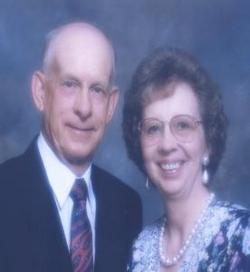
| Description | : | Joan L. Moore, daughter of Joseph and Viola (Guilford) Danielson, was born in Aurora on April 25, 1932. She attended Aurora country & public schools, graduating in 1949. She worked for First Securities in Aurora. On April 26, 1953 she married Lloyd Charles Moore in Aurora. She worked at the Hamilton County Courthouse in the treasurer's office and in 1978 she began working as a secretary at International Sensor Systems Inc. in Aurora, a position she held at the time of her death. She was an active member of the United Methodist Church in Aurora. She also belonged to the... Read More |
frequently asked questions (FAQ):
-
Where is Joan Luree Danielson Moore's memorial?
Joan Luree Danielson Moore's memorial is located at: Inskip Baptist Churchyard, Inskip with Sowerby, Wyre Borough, England.
-
When did Joan Luree Danielson Moore death?
Joan Luree Danielson Moore death on 21 May 1997 in Omaha, Douglas County, Nebraska, USA
-
Where are the coordinates of the Joan Luree Danielson Moore's memorial?
Latitude: 53.8353150
Longitude: -2.8299610
Family Members:
Parent
Siblings
Flowers:


Nearby Cemetories:
1. Inskip Baptist Churchyard
Inskip with Sowerby, Wyre Borough, England
Coordinate: 53.8353150, -2.8299610
2. St. Peters Churchyard
Inskip with Sowerby, Wyre Borough, England
Coordinate: 53.8347100, -2.8175200
3. St. Michael’s Churchyard
St Michael's on Wyre, Wyre Borough, England
Coordinate: 53.8628050, -2.8195430
4. Elswick Congregational Chapelyard
Elswick, Fylde Borough, England
Coordinate: 53.8378950, -2.8775320
5. St Mary Roman Catholic Churchyard
Great Eccleston, Wyre Borough, England
Coordinate: 53.8535420, -2.8710090
6. Christ Churchyard
Treales, Fylde Borough, England
Coordinate: 53.8045970, -2.8440710
7. St Anne Churchyard
Great Eccleston, Wyre Borough, England
Coordinate: 53.8481413, -2.8835925
8. St. Helen's Churchyard
Kirkland (Churchtown), Wyre Borough, England
Coordinate: 53.8790700, -2.7901000
9. Saint Anne's Church
Woodplumpton, City of Preston, England
Coordinate: 53.8038130, -2.7621940
10. Saint Joseph's Roman Catholic Church
Wesham, Fylde Borough, England
Coordinate: 53.7928600, -2.8871800
11. St. Hilda's Churchyard
Bilsborrow, Wyre Borough, England
Coordinate: 53.8522170, -2.7420090
12. St Mary's Newhouse
Barton, City of Preston, England
Coordinate: 53.8205240, -2.7406500
13. St. John’s Churchyard
Out Rawcliffe, Wyre Borough, England
Coordinate: 53.8741650, -2.8959310
14. Christ Church Churchyard
Wesham, Fylde Borough, England
Coordinate: 53.7905000, -2.8845600
15. St. Lawrence Churchyard
Barton, City of Preston, England
Coordinate: 53.8289213, -2.7366654
16. St Michael Churchyard
Kirkham, Fylde Borough, England
Coordinate: 53.7843570, -2.8709520
17. Zion Chapel Cemetery
Kirkham, Fylde Borough, England
Coordinate: 53.7814380, -2.8721260
18. St. John the Evangelist Churchyard
Clifton, Fylde Borough, England
Coordinate: 53.7758600, -2.8158500
19. Kirkland Strict and Particular Baptist Chapel
Nateby, Wyre Borough, England
Coordinate: 53.8961210, -2.8170130
20. St Anne Churchyard
Singleton, Fylde Borough, England
Coordinate: 53.8379280, -2.9359890
21. St. Anne's Churchyard
Blackburn, Blackburn with Darwen Unitary Authority, England
Coordinate: 53.8381160, -2.9362870
22. St Andrew George Haydock Roman Catholic Churchyard
Cottam, City of Preston, England
Coordinate: 53.7879280, -2.7591570
23. Saint John the Evangelist Churchyard
Kirkham, Fylde Borough, England
Coordinate: 53.7808000, -2.8873870
24. St. Mary's Churchyard
Lea, City of Preston, England
Coordinate: 53.7733810, -2.7942770