
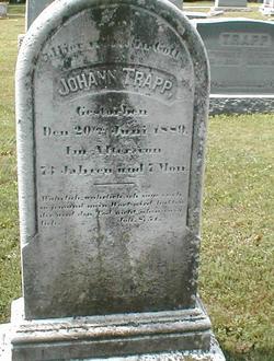
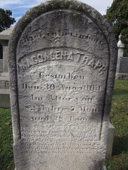
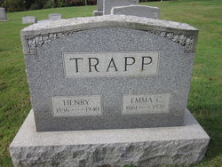
Johann Trapp
| Birth | : | 2 Oct 1815 Bavaria (Bayern), Germany |
| Death | : | 20 Jun 1889 Blenheim, Baltimore County, Maryland, USA |
| Burial | : | North Watford Cemetery, Watford, Watford Borough, England |
| Coordinate | : | 51.6832680, -0.4033640 |
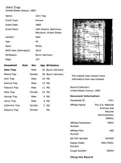
| Description | : | Date of birth from death and age 73 years, 7 months and 14 days as recorded in the St. John's Lutheran Church of Blenheim death records. Name: John Trapp Age in 1870: 58 Birth Year: abt 1812 Birthplace: Deutschland Dwelling Number: 193 Home in 1870: District 10, Baltimore, Maryland Race: White Gender: Male Occupation: Farmer Father of Foreign Birth: Y Mother of Foreign Birth: Y Male Citizen over 21: Y Personal Estate Value: 800 Real Estate Value: 4000 Household Members: Name Age John Trapp 58 Mettena/Magdalena Trapp 48 Samuel Trapp 25 Frederick Trapp 21 Mary E Trapp 19 |
frequently asked questions (FAQ):
-
Where is Johann Trapp's memorial?
Johann Trapp's memorial is located at: North Watford Cemetery, Watford, Watford Borough, England.
-
When did Johann Trapp death?
Johann Trapp death on 20 Jun 1889 in Blenheim, Baltimore County, Maryland, USA
-
Where are the coordinates of the Johann Trapp's memorial?
Latitude: 51.6832680
Longitude: -0.4033640
Family Members:
Spouse
Children

Flowers:


Nearby Cemetories:
1. North Watford Cemetery
Watford, Watford Borough, England
Coordinate: 51.6832680, -0.4033640
2. All Saints Churchyard
Watford Borough, England
Coordinate: 51.6954810, -0.3885560
3. West Herts Crematorium
Watford, Watford Borough, England
Coordinate: 51.7004195, -0.3847509
4. St. Paul Churchyard
Kings Langley, Dacorum Borough, England
Coordinate: 51.6931700, -0.4383900
5. East Lane Cemetery
Leavesden, Three Rivers District, England
Coordinate: 51.7084796, -0.4036263
6. St Lawrence the Martyr Churchyard
Abbots Langley, Three Rivers District, England
Coordinate: 51.7077650, -0.4170030
7. St. Mary's Churchyard
Watford, Watford Borough, England
Coordinate: 51.6546240, -0.3958510
8. Vicarage Road Cemetery
Watford, Watford Borough, England
Coordinate: 51.6517850, -0.4008620
9. St. John the Baptist Churchyard
Aldenham, Hertsmere Borough, England
Coordinate: 51.6734130, -0.3531610
10. Sir David Yule Mausoleum
St Albans, St Albans District, England
Coordinate: 51.7024660, -0.3505190
11. Bushey Jewish Cemetery
Bushey, Watford Borough, England
Coordinate: 51.6580150, -0.3572810
12. All Saints Churchyard
Kings Langley, Dacorum Borough, England
Coordinate: 51.7109030, -0.4479280
13. St. James' Churchyard
Bushey, Watford Borough, England
Coordinate: 51.6443700, -0.3679250
14. Kings Langley Priory
Kings Langley, Dacorum Borough, England
Coordinate: 51.7130000, -0.4603000
15. Bushey United Reformed Congregational Churchyard
Bushey, Watford Borough, England
Coordinate: 51.6440000, -0.3611200
16. Christ Church
Radlett, Hertsmere Borough, England
Coordinate: 51.6802460, -0.3163610
17. Holy Trinity Churchyard
St Albans, St Albans District, England
Coordinate: 51.7170354, -0.3334244
18. Frogmore Holy Trinity Burial Ground
St Albans District, England
Coordinate: 51.7197598, -0.3365342
19. Oxhey Chapel Burial Ground
Three Rivers District, England
Coordinate: 51.6279000, -0.3927500
20. Chorleywood Road Cemetery
Rickmansworth, Three Rivers District, England
Coordinate: 51.6440320, -0.4753040
21. Church of the Holy Cross Churchyard
Sarratt, Three Rivers District, England
Coordinate: 51.6747100, -0.4991540
22. Carpenders Park Lawn Cemetery
Watford, Watford Borough, England
Coordinate: 51.6258920, -0.3707550
23. St Mary's Church Apsley End
Apsley, Dacorum Borough, England
Coordinate: 51.7347710, -0.4659480
24. Holy Trinity Churchyard
Leverstock Green, Dacorum Borough, England
Coordinate: 51.7466800, -0.4295770