
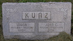
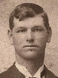
John C Kunz
| Birth | : | 11 Nov 1865 |
| Death | : | 4 Nov 1950 |
| Burial | : | St. Mary's Churchyard, Thorpe Morieux, Babergh District, England |
| Coordinate | : | 52.1443020, 0.8387590 |
frequently asked questions (FAQ):
-
Where is John C Kunz's memorial?
John C Kunz's memorial is located at: St. Mary's Churchyard, Thorpe Morieux, Babergh District, England.
-
When did John C Kunz death?
John C Kunz death on 4 Nov 1950 in
-
Where are the coordinates of the John C Kunz's memorial?
Latitude: 52.1443020
Longitude: 0.8387590
Family Members:
Parent
Spouse

Siblings
Flowers:


Nearby Cemetories:
1. St. Mary's Churchyard
Thorpe Morieux, Babergh District, England
Coordinate: 52.1443020, 0.8387590
2. St. Mary The Virgin Churchyard
Brettenham, Babergh District, England
Coordinate: 52.1509480, 0.8742360
3. St Mary's Churchyard
Preston St Mary, Babergh District, England
Coordinate: 52.1166280, 0.8410180
4. Cockfield Congregational Churchyard
Cockfield, Babergh District, England
Coordinate: 52.1635212, 0.7976324
5. St. Peter's Churchyard
Felsham, Mid Suffolk District, England
Coordinate: 52.1769650, 0.8458780
6. Cockfield Burial Ground
Cockfield, Babergh District, England
Coordinate: 52.1587375, 0.7894545
7. St Mary Churchyard
Kettlebaston, Babergh District, England
Coordinate: 52.1158580, 0.8698780
8. St Peter's Churchyard
Cockfield, Babergh District, England
Coordinate: 52.1597570, 0.7826470
9. All Saints Churchyard
Hitcham, Babergh District, England
Coordinate: 52.1226340, 0.8974440
10. St. Mary's Churchyard
Gedding, Mid Suffolk District, England
Coordinate: 52.1865920, 0.8540510
11. St Mary Churchyard
Brent Eleigh, Babergh District, England
Coordinate: 52.0983910, 0.8341560
12. Saint Peter and Saint Paul Churchyard
Lavenham, Babergh District, England
Coordinate: 52.1062530, 0.7917130
13. Saint Clare
Bradfield St Clare, St Edmundsbury Borough, England
Coordinate: 52.1854050, 0.7920340
14. Lavenham Cemetery
Lavenham, Babergh District, England
Coordinate: 52.1039670, 0.7883200
15. St Mary Magdelene
Bildeston, Babergh District, England
Coordinate: 52.1056020, 0.8982980
16. Saint Peter's Churchyard
Monks Eleigh, Babergh District, England
Coordinate: 52.0930860, 0.8688960
17. Monks Eleigh United Reformed Church
Monks Eleigh, Babergh District, England
Coordinate: 52.0918390, 0.8673530
18. Bradfield Combust Methodist Churchyard
Bradfield Combust, St Edmundsbury Borough, England
Coordinate: 52.1727200, 0.7602400
19. Rattlesden Baptist Church
Rattlesden, Mid Suffolk District, England
Coordinate: 52.1924020, 0.8885300
20. All Saints Churchyard
Bradfield Combust, St Edmundsbury Borough, England
Coordinate: 52.1814730, 0.7663800
21. All Saints Churchyard
Chelsworth, Babergh District, England
Coordinate: 52.0941820, 0.8896270
22. St Nicholas Churchyard
Rattlesden, Mid Suffolk District, England
Coordinate: 52.1941810, 0.8926210
23. Wattisham Baptist Chapelyard
Wattisham, Babergh District, England
Coordinate: 52.1295550, 0.9353850
24. St Nicholas Churchyard
Wattisham, Babergh District, England
Coordinate: 52.1241910, 0.9344540