
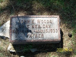


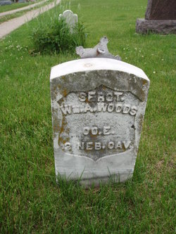
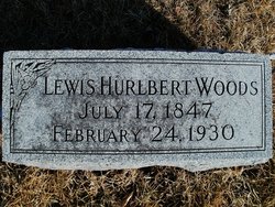
John Edgar Woods
| Birth | : | 14 Nov 1841 Madison, Jefferson County, Indiana, USA |
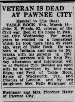
| Death | : | 15 Mar 1933 Pawnee City, Pawnee County, Nebraska, USA |
| Burial | : | Calvary Cemetery, Springfield, Clark County, USA |
| Coordinate | : | 39.8843994, -83.7585983 |
| Description | : | married Charlotte Small 11 Feb 1867 |
frequently asked questions (FAQ):
-
Where is John Edgar Woods's memorial?
John Edgar Woods's memorial is located at: Calvary Cemetery, Springfield, Clark County, USA.
-
When did John Edgar Woods death?
John Edgar Woods death on 15 Mar 1933 in Pawnee City, Pawnee County, Nebraska, USA
-
Where are the coordinates of the John Edgar Woods's memorial?
Latitude: 39.8843994
Longitude: -83.7585983
Family Members:
Parent
Spouse
Siblings

Children

Flowers:


Nearby Cemetories:
1. Calvary Cemetery
Springfield, Clark County, USA
Coordinate: 39.8843994, -83.7585983
2. Steele Cemetery
Springfield, Clark County, USA
Coordinate: 39.8702510, -83.7698680
3. Hinkle Cemetery
Springfield, Clark County, USA
Coordinate: 39.8817177, -83.7870636
4. Garlough Cemetery
Pitchin, Clark County, USA
Coordinate: 39.8563995, -83.7592010
5. Rose Hill Burial Park
Springfield, Clark County, USA
Coordinate: 39.8903008, -83.7192001
6. Greenmount Cemetery
Springfield, Clark County, USA
Coordinate: 39.9211006, -83.7889023
7. Pitchin Methodist Church Cemetery
Pitchin, Clark County, USA
Coordinate: 39.8408160, -83.7591690
8. Pleasant Grove Baptist Cemetery
Clark County, USA
Coordinate: 39.8457200, -83.7292900
9. Yale Cemetery
Clark County, USA
Coordinate: 39.9258003, -83.7257996
10. Yale Cemetery
Springfield, Clark County, USA
Coordinate: 39.9258935, -83.7257592
11. Fletcher Chapel Cemetery
Harmony, Clark County, USA
Coordinate: 39.8936005, -83.6956024
12. Saint Raphael's Cemetery
Springfield, Clark County, USA
Coordinate: 39.9305992, -83.7869034
13. Sinking Creek Cemetery
Clark County, USA
Coordinate: 39.9290000, -83.7250000
14. Christ Episcopal Church Columbarium
Springfield, Clark County, USA
Coordinate: 39.9226150, -83.8037060
15. Tuttle Cemetery
Clark County, USA
Coordinate: 39.9331017, -83.7213974
16. Buffenbarger Cemetery
Pitchin, Clark County, USA
Coordinate: 39.8372002, -83.7121964
17. Columbia Street Cemetery
Springfield, Clark County, USA
Coordinate: 39.9263992, -83.8131027
18. Emery Chapel Cemetery
Springfield, Clark County, USA
Coordinate: 39.8746986, -83.8416977
19. Titus Cemetery
Clark County, USA
Coordinate: 39.9155998, -83.6836014
20. Laybourn Cemetery
Clark County, USA
Coordinate: 39.9157740, -83.6832810
21. Newcomers Cemetery
Springfield, Clark County, USA
Coordinate: 39.9500008, -83.7668991
22. Ferncliff Cemetery
Springfield, Clark County, USA
Coordinate: 39.9375000, -83.8218994
23. Wraggs Cemetery
Clark County, USA
Coordinate: 39.9028015, -83.6667023
24. Clark County Children's Home Cemetery
Springfield, Clark County, USA
Coordinate: 39.9506156, -83.8004840