
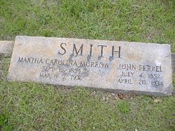
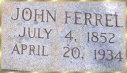
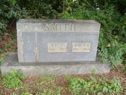
John Ferrel Smith
| Birth | : | 4 Jul 1852 Blacksburg, Cherokee County, South Carolina, USA |
| Death | : | 20 Apr 1934 Belmont, Gaston County, North Carolina, USA |
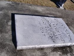
| Burial | : | Druids Occidental Cemetery, Occidental, Sonoma County, USA |
| Coordinate | : | 38.4104996, -122.9419022 |
| Description | : | Name: John Ferrell Smith Titles and Terms: Event Type: Death Event Date: 19 Apr 1934 Event Place: So. Point, Gaston, North Carolina Birth Year: 1852 Birth Year (Estimated): Burial Date: 20 Apr 1934 Burial Place: Blacksburg, S.C. Cemetery: Baptist Cemetery Funeral Home: Residence Place: Belmont, N.C. Address: Gender: Male Age: 81 Marital Status: Married Race (Original): White Occupation: Birth Date: 04 Jul 1852 Birthplace: Blacksburg, S.C. Father's Name: J. C. Smith Father's Titles and Terms: Father's Birthplace: Blacksburg, S.C. Mother's Name: Nancy James Mother's Titles and Terms: Mother's Birthplace: Blacksburg, S.C. Spouse's Name: Martha Caraline Smith Spouse's Titles and Terms: |
frequently asked questions (FAQ):
-
Where is John Ferrel Smith's memorial?
John Ferrel Smith's memorial is located at: Druids Occidental Cemetery, Occidental, Sonoma County, USA.
-
When did John Ferrel Smith death?
John Ferrel Smith death on 20 Apr 1934 in Belmont, Gaston County, North Carolina, USA
-
Where are the coordinates of the John Ferrel Smith's memorial?
Latitude: 38.4104996
Longitude: -122.9419022
Family Members:
Parent
Spouse

Siblings
Children


Nearby Cemetories:
1. Druids Occidental Cemetery
Occidental, Sonoma County, USA
Coordinate: 38.4104996, -122.9419022
2. Jasper O'Farrell Ranch Cemetery
Freestone, Sonoma County, USA
Coordinate: 38.3758300, -122.9090300
3. Gilliam Cemetery
Graton, Sonoma County, USA
Coordinate: 38.4314995, -122.8816986
4. Green Valley Cemetery
Sebastopol, Sonoma County, USA
Coordinate: 38.4424019, -122.8869019
5. Spring Hill Cemetery
Sebastopol, Sonoma County, USA
Coordinate: 38.3968010, -122.8637009
6. Saint Theresa of Avila Church Cemetery
Bodega, Sonoma County, USA
Coordinate: 38.3461342, -122.9723663
7. Forestview Cemetery
Forestville, Sonoma County, USA
Coordinate: 38.4677010, -122.8834000
8. Calvary Cemetery
Bodega, Sonoma County, USA
Coordinate: 38.3414993, -122.9749985
9. Saint Catherines Church Cemetery
Monte Rio, Sonoma County, USA
Coordinate: 38.4691010, -123.0104980
10. Sebastopol Memorial Lawn Cemetery
Sebastopol, Sonoma County, USA
Coordinate: 38.3981018, -122.8366013
11. Pleasant Hills Memorial Park and Mortuary
Sebastopol, Sonoma County, USA
Coordinate: 38.3792000, -122.8350983
12. McPeak Cemetery
Hacienda, Sonoma County, USA
Coordinate: 38.5097008, -122.9272003
13. McPeak Cemetery
Forestville, Sonoma County, USA
Coordinate: 38.5098190, -122.9280929
14. Duncans Mills Cemetery
Duncans Mills, Sonoma County, USA
Coordinate: 38.4593560, -123.0547780
15. Redwood Memorial Gardens
Guerneville, Sonoma County, USA
Coordinate: 38.5071983, -122.9927979
16. Steele Family Cemetery
Santa Rosa, Sonoma County, USA
Coordinate: 38.4523730, -122.8065610
17. Bodega Bay Cemetery
Bodega Bay, Sonoma County, USA
Coordinate: 38.3172740, -123.0257990
18. Canfield Cemetery
Sebastopol, Sonoma County, USA
Coordinate: 38.3512430, -122.8147040
19. Bloomfield Cemetery
Bloomfield, Sonoma County, USA
Coordinate: 38.3135986, -122.8583984
20. Del Stewart Ranch Cemetery
Cazadero, Sonoma County, USA
Coordinate: 38.4998290, -123.0793090
21. Macedonia Methodist Episcopal Church Cemetery
Sebastopol, Sonoma County, USA
Coordinate: 38.3594860, -122.7727270
22. Kricke Ranch Cemetery
Cazadero, Sonoma County, USA
Coordinate: 38.5036910, -123.0790620
23. Fulton Cemetery
Fulton, Sonoma County, USA
Coordinate: 38.4888000, -122.7786026
24. Santa Rosa Memorial Park Shiloh Annex
Windsor, Sonoma County, USA
Coordinate: 38.5247993, -122.8143005