

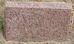
John Grant Terry
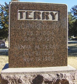
| Birth | : | 7 Feb 1865 Daviess County, Missouri, USA |
| Death | : | 19 Jul 1917 Wauneta, Chase County, Nebraska, USA |
| Burial | : | St Peter & Paul Churchyard, Preston, Rutland Unitary Authority, England |
| Coordinate | : | 52.6122600, -0.7162560 |
| Description | : | John Grant Terry Sex: M Birth: 7 FEB 1865 in Daviess County, Missouri Death: 19 JUL 1917 in Wauneta, Chase County, Neb;buried Riverside Cemetery, Wauneta, Neb. Father: Robert Jackson Terry b: 10 APR 1832 in Franklin County, Indiana Mother: Susan Mariah Hammons b: 10 JUN 1845 in Johnson County, Mo Marriage 1 Anna Martin b: 1 JAN 1869 Married: 4 JUL 1886 Children Ollie L. Terry b: 7 JUN 1889 in Daviess County, Mo Ruth Mae Terry b: 9 FEB 1893 Robert Nay Terry b: 6 FEB 1896 in Daviess County, Mo+Buried In Rverside Alvie Dewey Terry b: 31 MAY 1898 Maude Terry... Read More |
frequently asked questions (FAQ):
-
Where is John Grant Terry's memorial?
John Grant Terry's memorial is located at: St Peter & Paul Churchyard, Preston, Rutland Unitary Authority, England.
-
When did John Grant Terry death?
John Grant Terry death on 19 Jul 1917 in Wauneta, Chase County, Nebraska, USA
-
Where are the coordinates of the John Grant Terry's memorial?
Latitude: 52.6122600
Longitude: -0.7162560
Family Members:
Parent
Spouse
Siblings

Children
Flowers:


Nearby Cemetories:
1. St Peter & Paul Churchyard
Preston, Rutland Unitary Authority, England
Coordinate: 52.6122600, -0.7162560
2. St. Mary the Virgin Churchyard
Uppingham, Rutland Unitary Authority, England
Coordinate: 52.5996800, -0.7324400
3. Leicester Road Cemetery
Uppingham, Rutland Unitary Authority, England
Coordinate: 52.5975766, -0.7413414
4. St. Peter and St. Paul's Churchyard
Wing, Rutland Unitary Authority, England
Coordinate: 52.6172140, -0.6814150
5. St. Peter and St. Paul's Churchyard
Uppingham, Rutland Unitary Authority, England
Coordinate: 52.5873820, -0.7221660
6. Uppingham Lawn Cemetery
Uppingham, Rutland Unitary Authority, England
Coordinate: 52.5855800, -0.7229700
7. St. Andrew's Churchyard
Glaston, Rutland Unitary Authority, England
Coordinate: 52.5953628, -0.6781534
8. St Nicholas Churchyard
Pilton, Rutland Unitary Authority, England
Coordinate: 52.6165200, -0.6504100
9. All Hallows Churchyard
Seaton, Rutland Unitary Authority, England
Coordinate: 52.5745730, -0.6670810
10. St Peter Churchyard
Belton, Rutland Unitary Authority, England
Coordinate: 52.6038200, -0.7957000
11. St Mary the Virgin Churchyard
Morcott, Rutland Unitary Authority, England
Coordinate: 52.5967800, -0.6366200
12. St Andrew Churchyard
Stoke Dry, Rutland Unitary Authority, England
Coordinate: 52.5620632, -0.7394099
13. St Andrew Churchyard
Hambleton, Rutland Unitary Authority, England
Coordinate: 52.6585060, -0.6712280
14. St. Peter's Churchyard
Stockerston, Harborough District, England
Coordinate: 52.5687800, -0.7706600
15. St Mary the Virgin Churchyard
Edith Weston, Rutland Unitary Authority, England
Coordinate: 52.6379100, -0.6311100
16. St. John The Baptist Church
North Luffenham, Rutland Unitary Authority, England
Coordinate: 52.6186570, -0.6211140
17. Saint John The Baptist Churchyard
Harringworth, East Northamptonshire Borough, England
Coordinate: 52.5671000, -0.6491000
18. St Mary the Virgin Churchyard
South Luffenham, Rutland Unitary Authority, England
Coordinate: 52.6067200, -0.6114100
19. Oakham Cemetery
Oakham, Rutland Unitary Authority, England
Coordinate: 52.6768700, -0.7297400
20. Launde Abbey
Launde, Harborough District, England
Coordinate: 52.6313950, -0.8233060
21. St. Peter's Churchyard
Barrowden, Rutland Unitary Authority, England
Coordinate: 52.5888800, -0.6063600
22. Withcote Chapel
Harborough District, England
Coordinate: 52.6440500, -0.8253346
23. St. James Churchyard
Gretton, Corby Borough, England
Coordinate: 52.5403000, -0.6763400
24. St. John the Evangelist Churchyard
Caldecott, Rutland Unitary Authority, England
Coordinate: 52.5341600, -0.7213400