
| Birth | : | 28 Feb 1846 Monterey, Davis County, Iowa, USA |
| Death | : | 1 Oct 1890 Bloomfield, Davis County, Iowa, USA |
| Burial | : | Boxford Cemetery, Boxford, Babergh District, England |
| Coordinate | : | 52.0268400, 0.8601300 |
| Plot | : | Section 2 |
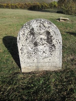
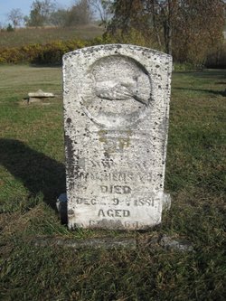
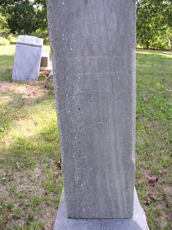
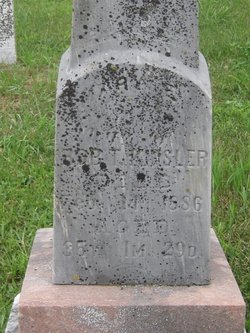
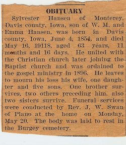
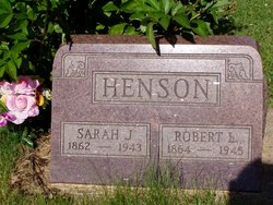
| Description | : | John H. Henson was born 28 February 1846, in Monterey, Fabius Township, Davis County, Iowa to William and Emily (Johnson) Henson. On 11 July 1868 he married Letitia Votaw and they had 5 children: Samuel Stuart (23 Aug 1869 - 16 Dec 1938); Mary Elmira b. 1871; Julia Adelaide b. Dec 1875; Laura "Nettie" (13 Sep 1877 - 3 Jul 1897; and William W. b. 1882. He was elected county treasurer (Davis County) in 1883, and he served 4 years. John died 1 October 1890 and shares his gravestone with his wife and daughter, "Nettie". |
frequently asked questions (FAQ):
-
Where is John Harrison Henson's memorial?
John Harrison Henson's memorial is located at: Boxford Cemetery, Boxford, Babergh District, England.
-
When did John Harrison Henson death?
John Harrison Henson death on 1 Oct 1890 in Bloomfield, Davis County, Iowa, USA
-
Where are the coordinates of the John Harrison Henson's memorial?
Latitude: 52.0268400
Longitude: 0.8601300
Family Members:
Parent
Spouse

Siblings
Children
Flowers:


Nearby Cemetories:
1. Boxford Cemetery
Boxford, Babergh District, England
Coordinate: 52.0268400, 0.8601300
2. St Mary's Churchyard
Boxford, Babergh District, England
Coordinate: 52.0280870, 0.8594160
3. St. Bartholomew's Churchyard
Groton, Babergh District, England
Coordinate: 52.0388810, 0.8558090
4. St Mary the Virgin Churchyard
Edwardstone, Babergh District, England
Coordinate: 52.0435300, 0.8283500
5. St Edmund King and Martyr Churchyard
Assington, Babergh District, England
Coordinate: 52.0138120, 0.8194260
6. World War I Memorial
Assington, Babergh District, England
Coordinate: 52.0138200, 0.8193504
7. St Mary Churchyard
Polstead, Babergh District, England
Coordinate: 52.0054860, 0.8964940
8. All Saints Churchyard
Newton, Babergh District, England
Coordinate: 52.0364000, 0.7966500
9. Saint Mary Churchyard
Stoke by Nayland, Babergh District, England
Coordinate: 51.9895000, 0.8925210
10. St Peter's Churchyard
Lindsey, Babergh District, England
Coordinate: 52.0672960, 0.8842620
11. St. Mary's Churchyard
Kersey, Babergh District, England
Coordinate: 52.0574611, 0.9190082
12. Nayland Cemetery
Nayland, Babergh District, England
Coordinate: 51.9735000, 0.8677410
13. Our Lady Immaculate Withermarsh Green
Stoke by Nayland, Babergh District, England
Coordinate: 51.9950800, 0.9326260
14. St Peter's Churchyard
Milden, Babergh District, England
Coordinate: 52.0824970, 0.8569200
15. St Lawrence Churchyard
Little Waldingfield, Babergh District, England
Coordinate: 52.0715620, 0.8059600
16. St Lawrence Churchyard
Great Waldingfield, Babergh District, England
Coordinate: 52.0606620, 0.7879070
17. All Saints Churchyard
Little Cornard, Babergh District, England
Coordinate: 52.0175530, 0.7703720
18. St. James' Churchyard
Nayland, Babergh District, England
Coordinate: 51.9715440, 0.8748140
19. Friars Road Cemetery
Hadleigh, Babergh District, England
Coordinate: 52.0481800, 0.9453100
20. St. Mary's Churchyard
Hadleigh, Babergh District, England
Coordinate: 52.0436290, 0.9526880
21. Hadleigh United Reformed Churchyard
Hadleigh, Babergh District, England
Coordinate: 52.0426790, 0.9533380
22. St. Andrew's Churchyard
Layham, Babergh District, England
Coordinate: 52.0240520, 0.9580820
23. St Andrew Churchyard
Great Cornard, Babergh District, England
Coordinate: 52.0304820, 0.7602450
24. Hadleigh Baptist Churchyard
Hadleigh, Babergh District, England
Coordinate: 52.0444510, 0.9562658