
| Birth | : | 5 Sep 1852 Wabash, Wabash County, Indiana, USA |
| Death | : | 11 Oct 1886 Bloomfield, Davis County, Iowa, USA |
| Burial | : | St Mary's Churchyard, Boxford, Babergh District, England |
| Coordinate | : | 52.0280870, 0.8594160 |
| Plot | : | Section 2 |
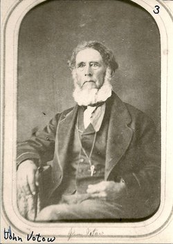
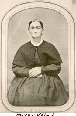
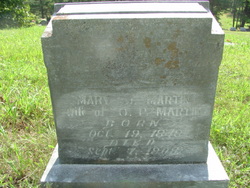
| Description | : | Letitia H. came from a long line of Quakers and was born in Wabash County, Indiana to John B. & Mary (Meredith) Votaw. The family moved to Davis County, Iowa where Letitia married John H. Henson. The marriage produced 5 children. Letitia died 11 October 1886 and is buried with her husband and daughter, "Nettie". |
frequently asked questions (FAQ):
-
Where is Letitia Hannah Votaw Henson's memorial?
Letitia Hannah Votaw Henson's memorial is located at: St Mary's Churchyard, Boxford, Babergh District, England.
-
When did Letitia Hannah Votaw Henson death?
Letitia Hannah Votaw Henson death on 11 Oct 1886 in Bloomfield, Davis County, Iowa, USA
-
Where are the coordinates of the Letitia Hannah Votaw Henson's memorial?
Latitude: 52.0280870
Longitude: 0.8594160
Family Members:
Parent
Spouse

Siblings
Children
Flowers:


Nearby Cemetories:
1. St Mary's Churchyard
Boxford, Babergh District, England
Coordinate: 52.0280870, 0.8594160
2. Boxford Cemetery
Boxford, Babergh District, England
Coordinate: 52.0268400, 0.8601300
3. St. Bartholomew's Churchyard
Groton, Babergh District, England
Coordinate: 52.0388810, 0.8558090
4. St Mary the Virgin Churchyard
Edwardstone, Babergh District, England
Coordinate: 52.0435300, 0.8283500
5. St Edmund King and Martyr Churchyard
Assington, Babergh District, England
Coordinate: 52.0138120, 0.8194260
6. World War I Memorial
Assington, Babergh District, England
Coordinate: 52.0138200, 0.8193504
7. St Mary Churchyard
Polstead, Babergh District, England
Coordinate: 52.0054860, 0.8964940
8. All Saints Churchyard
Newton, Babergh District, England
Coordinate: 52.0364000, 0.7966500
9. St Peter's Churchyard
Lindsey, Babergh District, England
Coordinate: 52.0672960, 0.8842620
10. Saint Mary Churchyard
Stoke by Nayland, Babergh District, England
Coordinate: 51.9895000, 0.8925210
11. St. Mary's Churchyard
Kersey, Babergh District, England
Coordinate: 52.0574611, 0.9190082
12. St Peter's Churchyard
Milden, Babergh District, England
Coordinate: 52.0824970, 0.8569200
13. St Lawrence Churchyard
Little Waldingfield, Babergh District, England
Coordinate: 52.0715620, 0.8059600
14. St Lawrence Churchyard
Great Waldingfield, Babergh District, England
Coordinate: 52.0606620, 0.7879070
15. Nayland Cemetery
Nayland, Babergh District, England
Coordinate: 51.9735000, 0.8677410
16. All Saints Churchyard
Little Cornard, Babergh District, England
Coordinate: 52.0175530, 0.7703720
17. Our Lady Immaculate Withermarsh Green
Stoke by Nayland, Babergh District, England
Coordinate: 51.9950800, 0.9326260
18. Friars Road Cemetery
Hadleigh, Babergh District, England
Coordinate: 52.0481800, 0.9453100
19. St. James' Churchyard
Nayland, Babergh District, England
Coordinate: 51.9715440, 0.8748140
20. St. Mary's Churchyard
Hadleigh, Babergh District, England
Coordinate: 52.0436290, 0.9526880
21. Hadleigh United Reformed Churchyard
Hadleigh, Babergh District, England
Coordinate: 52.0426790, 0.9533380
22. St. Andrew's Churchyard
Layham, Babergh District, England
Coordinate: 52.0240520, 0.9580820
23. St Andrew Churchyard
Great Cornard, Babergh District, England
Coordinate: 52.0304820, 0.7602450
24. Hadleigh Baptist Churchyard
Hadleigh, Babergh District, England
Coordinate: 52.0444510, 0.9562658