
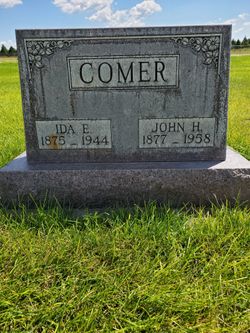
John Harvey Houston Comer
| Birth | : | 14 Sep 1877 Comers Rock, Grayson County, Virginia, USA |
| Death | : | 27 Feb 1958 Ingleside, Adams County, Nebraska, USA |
| Burial | : | Church and Clayton-le-Moors Cemetery, Accrington, Hyndburn Borough, England |
| Coordinate | : | 53.7630200, -2.3804820 |
| Description | : | NOTE: Father's name in the obit below was incorrectly listed as William. Funeral services for John Harvey Comer, 80, resident of the Brule community for 38 years, were held Monday afternoon in the Congregational church at Brule, with the pastor, Rev. Roberta Croker, and the Rev. Millard Gordanier of Imperial officiating. Mrs. Jack Buettenback, accompanied by Mrs. V. Lloyd Anderson at the piano, sang two hymns, "When the Roll is Called Up Yonder" and "Beyond the Sunset." Pallbearers were Max, Larry and James Comer, George Johnson, Emil Schuessler and George McCarty.... Read More |
frequently asked questions (FAQ):
-
Where is John Harvey Houston Comer's memorial?
John Harvey Houston Comer's memorial is located at: Church and Clayton-le-Moors Cemetery, Accrington, Hyndburn Borough, England.
-
When did John Harvey Houston Comer death?
John Harvey Houston Comer death on 27 Feb 1958 in Ingleside, Adams County, Nebraska, USA
-
Where are the coordinates of the John Harvey Houston Comer's memorial?
Latitude: 53.7630200
Longitude: -2.3804820
Family Members:
Parent
Spouse

Siblings
Children

Flowers:


Nearby Cemetories:
1. Church and Clayton-le-Moors Cemetery
Accrington, Hyndburn Borough, England
Coordinate: 53.7630200, -2.3804820
2. St James Churchyard
Church, Hyndburn Borough, England
Coordinate: 53.7574640, -2.3942660
3. All Saints Churchyard
Clayton-le-Moors, Hyndburn Borough, England
Coordinate: 53.7738520, -2.3881690
4. Barnes Square Weslyan Methodist Churchyard
Clayton-le-Moors, Hyndburn Borough, England
Coordinate: 53.7744350, -2.3853800
5. St. James' Parish Church
Accrington, Hyndburn Borough, England
Coordinate: 53.7519900, -2.3652600
6. St Marys Burial Ground
Clayton-le-Moors, Hyndburn Borough, England
Coordinate: 53.7792778, -2.3705871
7. Accrington Cemetery and Crematorium
Accrington, Hyndburn Borough, England
Coordinate: 53.7623787, -2.3508649
8. Christ Church Churchyard
Accrington, Hyndburn Borough, England
Coordinate: 53.7478560, -2.3605820
9. Great Harwood Cemetery
Great Harwood, Hyndburn Borough, England
Coordinate: 53.7796190, -2.4091680
10. Our Lady and Saint Hubert
Great Harwood, Hyndburn Borough, England
Coordinate: 53.7851070, -2.4009760
11. New Lane Baptist Chapel Chapelyard
Oswaldwistle, Hyndburn Borough, England
Coordinate: 53.7381100, -2.4049500
12. St. Bartholomew's Churchyard
Great Harwood, Hyndburn Borough, England
Coordinate: 53.7900670, -2.4055460
13. Immanuel Churchyard
Oswaldwistle, Hyndburn Borough, England
Coordinate: 53.7358300, -2.4056200
14. St. John the Baptist Churchyard
Baxenden, Hyndburn Borough, England
Coordinate: 53.7346500, -2.3470230
15. St James Church
Altham, Hyndburn Borough, England
Coordinate: 53.7928940, -2.3465250
16. St Margaret Churchyard
Hapton, Burnley Borough, England
Coordinate: 53.7802400, -2.3169230
17. St. John's Churchyard
Read, Ribble Valley Borough, England
Coordinate: 53.8088800, -2.3585600
18. St Leonard Churchyard Extension
Padiham, Burnley Borough, England
Coordinate: 53.7991800, -2.3222000
19. St. John's Cemetery
Padiham, Burnley Borough, England
Coordinate: 53.7948720, -2.3145290
20. Wesleyan Methodist Chapel Chapelyard
Padiham, Burnley Borough, England
Coordinate: 53.8018980, -2.3181730
21. St. Leonard's Churchyard
Padiham, Burnley Borough, England
Coordinate: 53.8022600, -2.3164300
22. Blackburn Cemetery
Blackburn, Blackburn with Darwen Unitary Authority, England
Coordinate: 53.7662430, -2.4726050
23. St Alban's Churchyard
Blackburn, Blackburn with Darwen Unitary Authority, England
Coordinate: 53.7530090, -2.4748540
24. Holy Trinity Church
Blackburn with Darwen Unitary Authority, England
Coordinate: 53.7511727, -2.4747178