
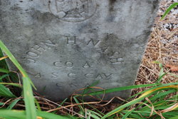
John Harvey Nash
| Birth | : | 22 Nov 1838 Fairview, Greenville County, South Carolina, USA |
| Death | : | 28 Jul 1921 Landrum, Spartanburg County, South Carolina, USA |
| Burial | : | Middleway Masonic Cemetery, Middleway, Jefferson County, USA |
| Coordinate | : | 39.3035860, -77.9800060 |
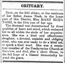
| Description | : | Confederate States of America Veteran, Co. A 4th SC Cal. He was the son of James NASH and Nancy HORNER NASH. These census records show he was married to Carrie Prior in 1900. Census shows they had been married 10 years. United States Census, 1870 Fairview, Greenville, SC Household Jno H Nash, 31 SC Eveline Nash, 34 SC Effie L Nash, 3 SC Nash, Female 0 SC Pinck Peden, Male 8 SC United States Census, 1880 Fairview, Greenville, SC Household John H Nash, Self 41 SC Eveline Nash, Wife 43 SC Effie L Nash, Daughter 13... Read More |
frequently asked questions (FAQ):
-
Where is John Harvey Nash's memorial?
John Harvey Nash's memorial is located at: Middleway Masonic Cemetery, Middleway, Jefferson County, USA.
-
When did John Harvey Nash death?
John Harvey Nash death on 28 Jul 1921 in Landrum, Spartanburg County, South Carolina, USA
-
Where are the coordinates of the John Harvey Nash's memorial?
Latitude: 39.3035860
Longitude: -77.9800060
Family Members:
Parent
Spouse

Siblings
Children
Flowers:


Nearby Cemetories:
1. Middleway Masonic Cemetery
Middleway, Jefferson County, USA
Coordinate: 39.3035860, -77.9800060
2. Grace Episcopal Church Cemetery
Middleway, Jefferson County, USA
Coordinate: 39.3035011, -77.9806976
3. Union Church Cemetery
Middleway, Jefferson County, USA
Coordinate: 39.3041560, -77.9817900
4. Watson Graveyard
Middleway, Jefferson County, USA
Coordinate: 39.3019000, -77.9822250
5. Weaver Family Cemetery
Middleway, Jefferson County, USA
Coordinate: 39.2981410, -77.9846050
6. Priestfield Pastoral Center Cemetery
Middleway, Jefferson County, USA
Coordinate: 39.3185143, -77.9886678
7. Fox Middleway Cemetery Lot
Kearneysville, Jefferson County, USA
Coordinate: 39.3225720, -77.9562790
8. Mountain View Church of the Brethren Cemetery
Inwood, Berkeley County, USA
Coordinate: 39.3320600, -78.0146000
9. Snider Cemetery
Jones Springs, Berkeley County, USA
Coordinate: 39.2912590, -78.0344780
10. Cedar Grove Christian Church Cemetery
Inwood, Berkeley County, USA
Coordinate: 39.3476900, -77.9884700
11. Washington Burial Ground
Charles Town, Jefferson County, USA
Coordinate: 39.3020379, -77.9163828
12. Saint Leo Cemetery
Inwood, Berkeley County, USA
Coordinate: 39.3541985, -77.9876022
13. Mount Zion A.M.E. Church Cemetery
Mount Pleasant, Jefferson County, USA
Coordinate: 39.2575322, -77.9485543
14. Paynes Chapel Cemetery
Bunker Hill, Berkeley County, USA
Coordinate: 39.2897700, -78.0539900
15. Poor Farm Cemetery
Kearneysville, Jefferson County, USA
Coordinate: 39.3345590, -77.9094350
16. Mount Tabor Church Cemetery
Bunker Hill, Berkeley County, USA
Coordinate: 39.3317032, -78.0534286
17. Prosperity Baptist Church Cemetery
Summit Point, Jefferson County, USA
Coordinate: 39.2387730, -77.9843590
18. Saint Bartholomews Episcopal Church Cemetery
Leetown, Jefferson County, USA
Coordinate: 39.3553800, -77.9269900
19. Bunker Hill Cemetery
Bunker Hill, Berkeley County, USA
Coordinate: 39.3339005, -78.0585022
20. Bullskin Presbyterian Churchyard
Summit Point, Jefferson County, USA
Coordinate: 39.2372940, -77.9578650
21. Jamestown Cemetery
Summit Point, Jefferson County, USA
Coordinate: 39.2346800, -77.9842300
22. Peter K. Johnson Farm Graveyard
Charles Town, Jefferson County, USA
Coordinate: 39.2617536, -77.9051369
23. Grace Bible Fellowship Cemetery
Clear Brook, Frederick County, USA
Coordinate: 39.2643747, -78.0620388
24. Johnsontown Cemetery
Johnsontown, Jefferson County, USA
Coordinate: 39.3404200, -77.8910700